Home
Images
Vectors
Videos
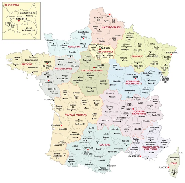
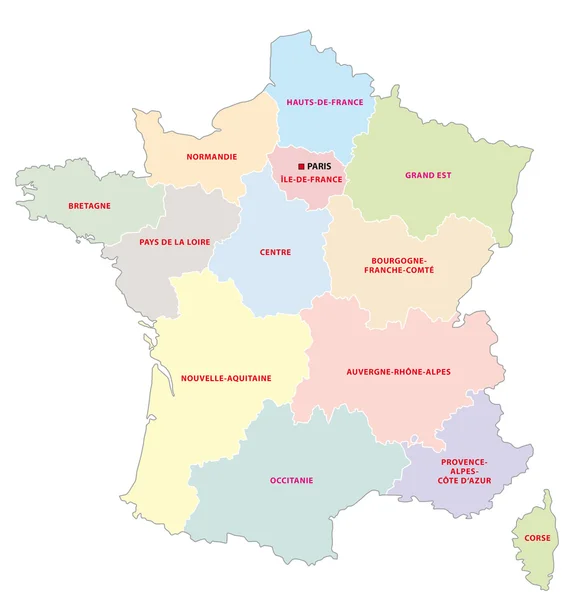
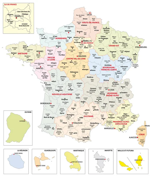
Stock vector Administrative map of the 13 regions of France and overseas territories
Published:
Dec.27, 2018 09:28:26
Author:
Lesniewski
Views:
143
Downloads:
20
File type:
vector
/
eps
File size:
2.77 MB
Orginal size:
3496
x
4071
px
Available sizes:
S
(429 x 500)
M
(859 x 1000)
L
(1718 x 2000)
XL
(3496 x 4071)
VECT
(3496 x 4071)
EL0
(3496 x 4071)
Level:
bronze
Download Vector
Vector topics:
Color
Vector
Colorful
Graphic
Illustration
Shape
New
Travel
European
French
Silhouette
Border
City
France
Europe
Country
Map
Cartography
Geography
Area
National
State
Political
Administrative
Department
Paris
Overseas
Region
Division
13
Cities
Bordeaux
Territory
Province
Regional
Reunion
Districts
Corsica
Provinces
Regions
Guyana
Martinique
Guadeloupe
Oversea
Departments
Mayotte
Guyane
Wallis And Futuna
Similar stock vectors
Administrative Map Of The 13 Regions Of France Since 2016
3446 × 3412
A Spain Province Map With 2-digit Zip Codes
4489 × 3459
Vector Colored Administrative Map Of Serbia. The Territory Of A European State With Large Cities, Borders Of Region
6475 × 9486
Map With The Twenty Clubs Of The First French Football League 2017- 2018
3324 × 3329
Highly Detailed Serbia Physical Map With Labeling.
2160 × 3043
Administrative Map Of The 13 Regions Of France Since 2016
4632 × 4840
Administrative Map Of The 13 Regions Of France Since 2016
3324 × 3329
Administrative Map Of The 13 Regions Of France Since 2016
3328 × 3333