Home
Images
Vectors
Videos
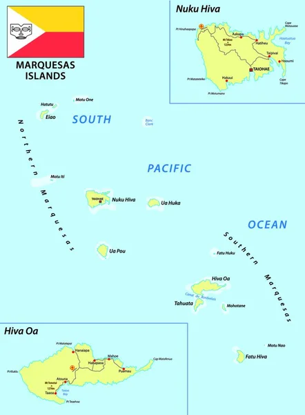
Stock vector Detailed vector map of Marquesas Islands
Published:
Sep.03, 2014 05:29:44
Author:
tkacchuk
Views:
90
Downloads:
0
File type:
vector
/
eps
File size:
3.28 MB
Orginal size:
5867
x
5867
px
Available sizes:
S
(500 x 500)
M
(1000 x 1000)
L
(2000 x 2000)
XL
(5867 x 5867)
VECT
(5867 x 5867)
EL0
(5867 x 5867)
Level:
silver
Download Vector
Vector topics:
Blue
Vector
Graphic
Illustration
Single
Travel
Line
Silhouette
Border
Symbol
Village
Icon
City
Flat
Physical
Contour
Edge
Education
Earth
World
Digitally
Surface
Detailed
Town
Capital
Outline
Country
District
Map
Cartography
Geography
Area
Land
Metropolis
Topography
Location
Place
Countries
Government
Political
Administrative
Region
Gps
Nation
Infographic
Similar stock vectors
Northern Mariana Islands Political Map
6974 × 8999
High Quality Map Of Rodrigues Island Is A Region Of Mauritius, With Borders Of The Districts
4000 × 4000
Detailed Vector Map Of Navassa Island
5867 × 5867
Balearic Islands Map With Indication Of Palma De Mallorca
4700 × 3384
Maluku Islands Vector Map
3100 × 3340
Vector Map Of The Mascarene Islands, Mauritius, Reunion, Rodrigues
4000 × 3717
Detailed Vector Map Of Cape Verde And Capital City Praia
5867 × 5867
Marquesas Islands Vector Map With Flag
3819 × 4000