Home
Images
Vectors
Videos
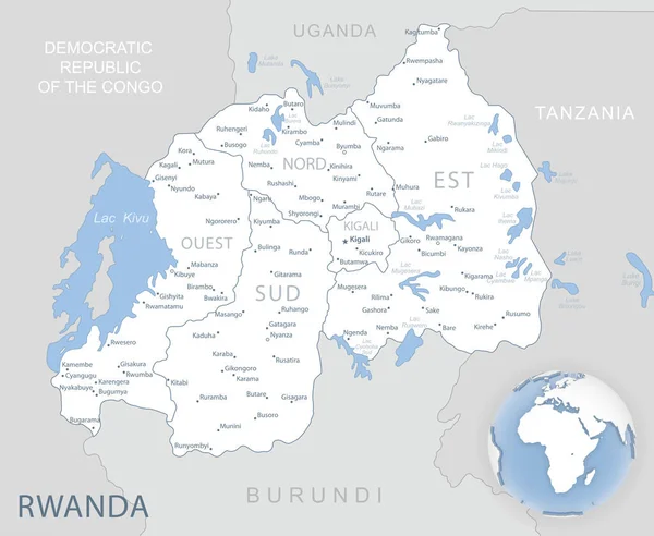
Stock vector Highly detailed vector map of Rwanda with administrative regions, main cities and roads.
Published:
Jul.06, 2020 09:00:58
Author:
BogdanSerban
Views:
8
Downloads:
0
File type:
vector
/
eps
File size:
1.58 MB
Orginal size:
3445
x
5000
px
Available sizes:
S
(345 x 500)
M
(689 x 1000)
L
(1378 x 2000)
XL
(3445 x 5000)
VECT
(3445 x 5000)
EL0
(3445 x 5000)
Level:
beginner
Download Vector
Vector topics:
Vector
Background
Illustration
Travel
Silhouette
Border
Road
City
Outline
Country
Map
Cartography
Geography
Africa
Continent
Destination
Eps
Tanganyika
Congo
Zaire
Tanzania
Burundi
Rwanda
Uganda
Bujumbura
Kigali
Kivu
Similar stock vectors
Highly Detailed Vector Map Of Burundi With Administrative Regions,main Cities And Roads.
4131 × 5000
Abstract Vector Color Map Of Rwanda And Burundi Country
2604 × 3730
Blue-gray Detailed Map Of Rwanda Administrative Divisions And Location On The Globe. Vector Illustration
6395 × 5251
African Great Lakes, Political Map
6979 × 9133
Kenya Map - Vintage Detailed Vector Illustration
5500 × 6586
Vector Map Of The Great African Lakes
3100 × 3902
Uganda Highly Detailed Vector Map With Administrative Regions,main Cities And Roads.
4090 × 5000
Highly Detailed Vector Map Of Malawi With Administrative Regions, Main Cities And Roads.
4175 × 5000