Home
Images
Vectors
Videos
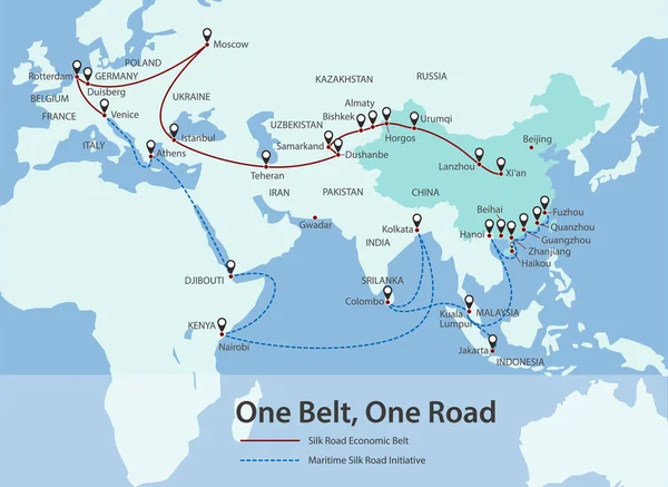
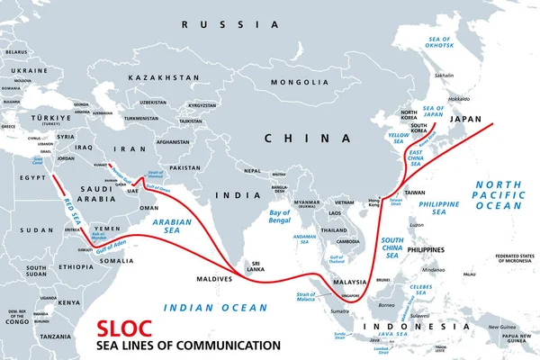
Stock vector Indo-Pacific major energy SLOCs, political map. Geopolitically critical Sea Lines Of Communication. Primary maritime routes between ports, used for trade, logistics and naval forces. Illustration.
Published:
Aug.06, 2022 08:24:55
Author:
Furian
Views:
24
Downloads:
2
File type:
vector
/
eps
File size:
3.03 MB
Orginal size:
9000
x
6000
px
Available sizes:
S
(500 x 333)
M
(1000 x 667)
L
(2000 x 1333)
XL
(9000 x 6000)
VECT
(9000 x 6000)
EL0
(9000 x 6000)
Level:
silver
Download Vector
Vector topics:
Vector
Transport
Oil
Energy
Sea
Lines
Communication
Shipping
Route
China
Map
Pacific
Port
Strategic
Maritime
Naval
International
Trade
Passage
Logistics
Strait
Thoroughfare
Malaysia
Critical
Operation
Atlas
Taiwan
Emirates
Indonesia
Waterway
Oman
Major
Iran
Malacca
Geopolitics
Red Sea
Saudi Arabia
Supply Chain
Suez Canal
Energy Crisis
Persian Gulf
Hormuz
Naval Force
China Sea
String Of Pearls
Bab El Mandeb
Choke Point
Taiwan Strait
Sloc
Sea Lines Of Communication
Similar stock vectors
INSTC, International NorthSouth Transport Corridor, Political Map. Network For Moving Freight, With Moscow As North End And Mumbai As South End, Replacing The Standard Route Across Mediterranean Sea.
8854 × 6000
One Belt, One Road, Chinese Strategic Investment In The 21st Century Map.
5501 × 4512
Map Of The Ancient Silk Road Between China And Europe
3200 × 2000
One Belt One Road. New Chinese Trade Silk Road. Vector Map Infographics Illustration
7160 × 3941
Abstract Blue Background Of China Maritime Trade Route (silk Road) With World Map
6000 × 3375
One Belt One Road. New Chinese Trade Silk Road. Vector Map Infographics Illustration
7160 × 3941
One Belt, One Road, Chinese Strategic Investment In The 21st Century Map.
5501 × 4009
Map Of The Marco Polo Voyages Through Asia Along The Silk Road
3200 × 2000