Home
Images
Vectors
Videos
Stock vector myanmar administrative map with regions and districts
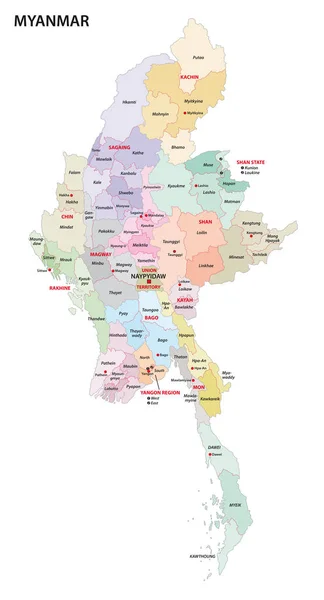
Published:
Jul.26, 2019 07:22:21
Author:
Lesniewski
Views:
80
Downloads:
1
File type:
vector
/
eps
File size:
1.63 MB
Orginal size:
3100
x
5740
px
Available sizes:
S
(270 x 500)
M
(540 x 1000)
L
(1080 x 2000)
XL
(3100 x 5740)
VECT
(3100 x 5740)
EL0
(3100 x 5740)
Level:
bronze
Download Vector
Vector topics:
Color
White
Vector
Background
Graphic
Illustration
Design
Isolated
Travel
Detail
Abstract
Border
Modern
Symbol
Creative
City
Outline
Country
District
Map
Cartography
Geography
Area
Land
Asia
State
Chart
Location
Boundary
Political
Administrative
Destination
Islands
Region
Division
Atlas
Southeast
Province
Nation
Myanmar
Burmese
Burma
Yangon
Rangoon
Naypyidaw
Infographic
Similar stock vectors
Myanmar Administrative Map With Regions And Districts
3627 × 4000
Myanmar Poster In Retro Style. Map Of The Country With Regions In Autumn Color Palette. Shape Of Myanmar With Country Name. Superb Vector Illustration.
3926 × 7664
Mosaic Myanmar Map Of Square Items
3400 × 5333
Myanmar Map With States And Modern Round Shapes
5000 × 8893
Myanmar Map Handdrawn Country Sightly Sketchy Myanmar Map With Regions Vector Illustration
5485 × 5485
Myanmar Burma Map With Location Pointer Marks. Infographic Vector Template, Isolated On White Background.
4000 × 5000
Vaccination Mosaic Map Of Myanmar
3956 × 4044
Modern National Map Vector Illustration
3333 × 3333