Home
Images
Vectors
Videos
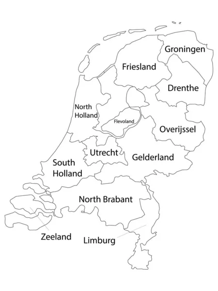
Stock vector Outline Netherlands map
Published:
Nov.23, 2009 14:28:52
Author:
Volina
Views:
4301
Downloads:
22
File type:
vector
/
eps
File size:
2.96 MB
Orginal size:
4604
x
5404
px
Available sizes:
S
(426 x 500)
M
(852 x 1000)
L
(1704 x 2000)
XL
(4604 x 5404)
VECT
(4604 x 5404)
EL0
(4604 x 5404)
Level:
silver
Download Vector
Vector topics:
White
Vector
Background
Illustration
Detail
European
Cut
Silhouette
Grunge
City
With
Contour
Grey
Euro
Netherlands
Holland
Gradient
Europe
Outline
Country
District
Map
Geography
National
Land
Splatter
State
Borders
Boundary
Administrative
Union
Community
Cities
Main
And
Atlas
Province
Dutch
Nation
Amsterdam
Realm
Nederland
Regions
Similar stock vectors
Netherlands Map
4604 × 5404
Labeled Provinces Map Of European Country Of Netherlands
3600 × 4800
Vector Map Of Netherlands
5452 × 6197
Detailed Map Of The Netherlands With Cities
4000 × 4000
Amsterdam, Netherlands. Detailed Country Map With Location Pin On Capital City. Black Silhouette And Outline Maps Isolated On White Background. EPS Vector
9376 × 7293
Shape Of Netherlands With Its Capital Isolated On White Background. Bilevel Elevation Map. 3D Rendering
1795 × 2126
Benelux Countries, Gray Colored Political Map. Belgium, Netherlands And Luxembourg. Benelux Union, A Geographic, Economic And Cultural Group. English Labeling. Illustration On White Background. Vector
6867 × 9333