Home
Images
Vectors
Videos
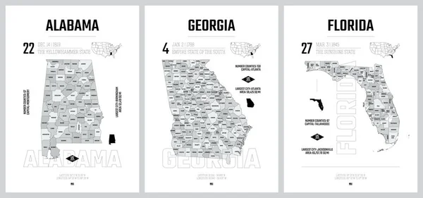
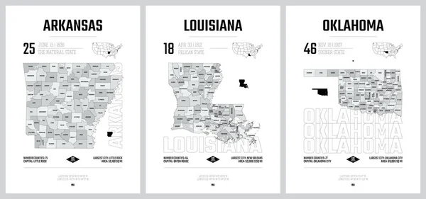
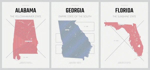
Stock vector Vector posters detailed silhouettes maps of the states of America with abstract linear pattern, Division South Atlantic and East South Central - Alabama, Georgia, Florida - set 10 of 17
Published:
Jun.01, 2021 10:21:51
Author:
Max_776
Views:
0
Downloads:
0
File type:
vector
/
eps
File size:
4.43 MB
Orginal size:
8896
x
4168
px
Available sizes:
S
(500 x 234)
M
(1000 x 469)
L
(2000 x 937)
XL
(8896 x 4168)
VECT
(8896 x 4168)
EL0
(8896 x 4168)
Level:
bronze
Download Vector
Vector topics:
Vector
View
High
Travel
Abstract
Cut
Line
Silhouette
Border
City
World
Usa
Detailed
East
Print
South
Outline
District
Map
Cartography
Plan
Land
State
Poster
America
Administrative
Atlantic
Politics
Stamp
Aerial
United
Georgia
Region
Division
Central
Separated
Federal
Florida
Nation
Borough
Alabama
Atlanta
Miami
Orlando
Jacksonville
Montgomery
Birmingham
Counties
United States
Similar stock vectors
Highly Detailed Vector Silhouettes Of US State Maps, Division United States Into Counties, Political And Geographic Subdivisions Of A States, South Atlantic And East South Central - Alabama, Georgia, Florida - Set 10 Of 17
9608 × 4501
Vector Posters Detailed Silhouettes Maps Of The States Of America With Abstract Linear Pattern, Division West South Central - Arkansas, Louisiana, Oklahoma - Set 12 Of 17
8896 × 4168
Vector Posters Detailed Silhouettes Maps Of The States Of America With Abstract Linear Pattern, Division East South Central - Mississippi, Kentucky, Tennessee - Set 11 Of 17
8896 × 4168
Vector Posters With Highly Detailed Silhouettes Of Maps Of The S
7292 × 3416
4 Of 50 Sets, US State Posters With Name And Information In 3 Design Styles, Detailed Vector Art Print Georgia Map
8896 × 4168
Highly Detailed Vector Silhouettes Of US State Maps, Division United States Into Counties, Political And Geographic Subdivisions Of A States, West South Central - Arkansas, Louisiana, Oklahoma - Set 12 Of 17
9608 × 4501
Highly Detailed Vector Silhouettes Of US State Maps, Division United States Into Counties, Political And Geographic Subdivisions Of A States, South Atlantic - South Carolina, North Carolina, Delaware - Set 9 Of 17
9608 × 4501
Highly Detailed Vector Silhouettes Of US State Maps, Division United States Into Counties, Political And Geographic Subdivisions Of A States, East South Central - Mississippi, Kentucky, Tennessee - Set 11 Of 17
9608 × 4501