photo free
Home Images Vectors Videos

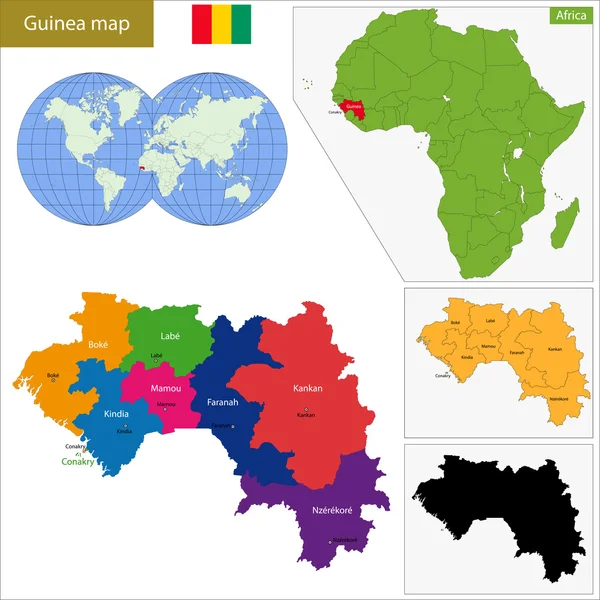
Stock image Guinea Administrative

stock vector Blue-green detailed map of Equatorial Guinea administrative divisions with country flag and location on the globe. Vector illustration

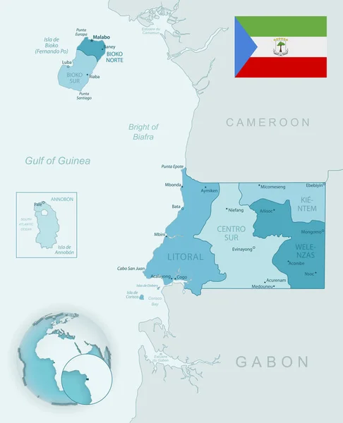
Blue-green Detailed Map Of Equatorial Guinea Administrative Divisions With Country Flag And Location On The Globe. Vector Illustration

Vector, 11.77MB, 5222 × 6442 eps
stock vector Blank Relief Map of Oceania isolated on white

Blank Relief Map Of Oceania Isolated On White

Vector, 5.13MB, 8192 × 5842 eps
stock image Set of illustrations of pointers in the form of flags of the countries of Australia and Oceania. Groups of Australasia, Micronesia, Melanesia and Polynesia.

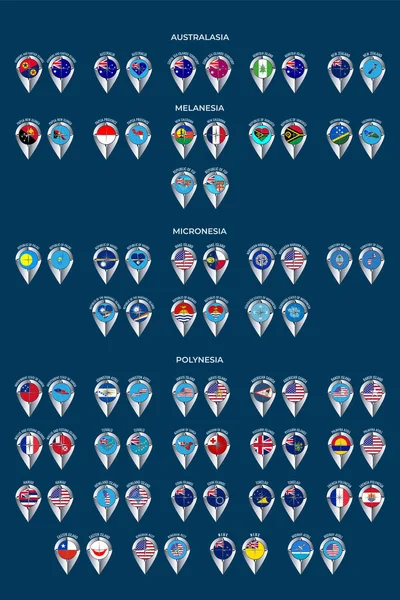
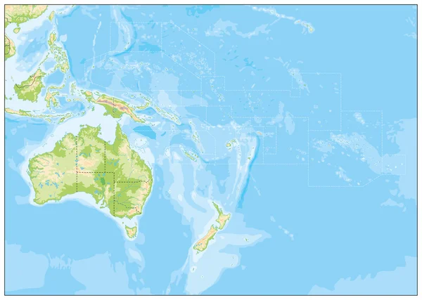
Set Of Illustrations Of Pointers In The Form Of Flags Of The Countries Of Australia And Oceania. Groups Of Australasia, Micronesia, Melanesia And Polynesia.

Image, 7.34MB, 5000 × 7501 jpg
stock vector Papua New Guinea map

Papua New Guinea Map

Vector, 7.87MB, 7021 × 4521 eps
stock vector Ghana map in gray on a white background

Ghana Map In Gray On A White Background

Vector, 0.74MB, 4167 × 4167 eps
stock vector Relief Map of Oceania isolated on white

Relief Map Of Oceania Isolated On White

Vector, 8.73MB, 8192 × 5842 eps
stock image Western Highlands, province of Papua New Guinea. Elevation map colored in wiki style with lakes and rivers. Locations and names of major cities of the region. Corner auxiliary location maps

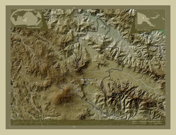
Western Highlands, Province Of Papua New Guinea. Elevation Map Colored In Wiki Style With Lakes And Rivers. Locations And Names Of Major Cities Of The Region. Corner Auxiliary Location Maps

Image, 11.85MB, 4930 × 3770 jpg
stock vector Guinea-Bissau map

Guinea-Bissau Map

Vector, 10.63MB, 7004 × 7004 eps
stock vector Central Africa map with flags

Central Africa Map With Flags

Vector, 1.23MB, 4348 × 4108 eps
stock vector Equatorial Guinea map

Equatorial Guinea Map

Vector, 9.59MB, 7004 × 7004 eps
stock vector Sao Tome and Principe

Sao Tome And Principe

Vector, 6.55MB, 4706 × 7004 eps
stock vector Blank Relief Map of Oceania

Blank Relief Map Of Oceania

Vector, 6.41MB, 8192 × 5842 eps
stock image Close-up of the Guinea border area on a physical map. Capital point. Glow around the country shape. English name of the country and its capital

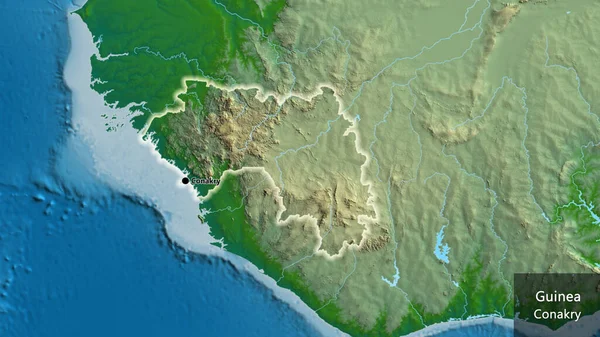
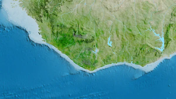
Close-up Of The Guinea Border Area On A Physical Map. Capital Point. Glow Around The Country Shape. English Name Of The Country And Its Capital

Image, 6.09MB, 3840 × 2160 jpg
stock image Close-up of asatellite map centered on Indonesia

Close-up Of Asatellite Map Centered On Indonesia

Image, 7.02MB, 3840 × 2160 jpg
stock vector Eastern Highlands Province map, administrative division of Papua New Guinea. Vector illustration.

Eastern Highlands Province Map, Administrative Division Of Papua New Guinea. Vector Illustration.

Vector, 6.58MB, 8334 × 8334 eps
stock vector Equatorial Guinea political map of administrative divisions - provinces. Shaded vector map with 3D-like blue gradient and name labels

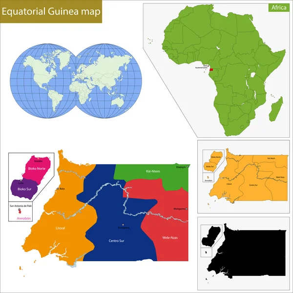
Equatorial Guinea Political Map Of Administrative Divisions - Provinces. Shaded Vector Map With 3D-like Blue Gradient And Name Labels

Vector, 0.28MB, 10000 × 10000 eps
stock vector Locator map showing the location of the country Equatorial Guinea in Africa. The country is highlighted with a red polygon. No labels at all. Made with Natural Earth.

Locator Map Showing The Location Of The Country Equatorial Guinea In Africa. The Country Is Highlighted With A Red Polygon. No Labels At All. Made With Natural Earth.

Vector, 1.14MB, 6660 × 5830 eps
stock vector Ghana country detailed editable map

Ghana Country Detailed Editable Map

Vector, 1.38MB, 4902 × 6000 eps
stock vector Gulf Province map, administrative division of Papua New Guinea. Vector illustration.

Gulf Province Map, Administrative Division Of Papua New Guinea. Vector Illustration.

Vector, 6.58MB, 8334 × 8334 eps
stock vector Southern Highlands Province map, administrative division of Papua New Guinea. Vector illustration.

Southern Highlands Province Map, Administrative Division Of Papua New Guinea. Vector Illustration.

Vector, 6.58MB, 8334 × 8334 eps
stock vector Hela Province map, administrative division of Papua New Guinea. Vector illustration.

Hela Province Map, Administrative Division Of Papua New Guinea. Vector Illustration.

Vector, 5.33MB, 8334 × 8334 eps
stock vector East Sepik Province map, administrative division of Papua New Guinea. Vector illustration.

East Sepik Province Map, Administrative Division Of Papua New Guinea. Vector Illustration.

Vector, 5.37MB, 8334 × 8334 eps
stock vector Tombali region map, administrative division of Guinea Bissau. Vector illustration.

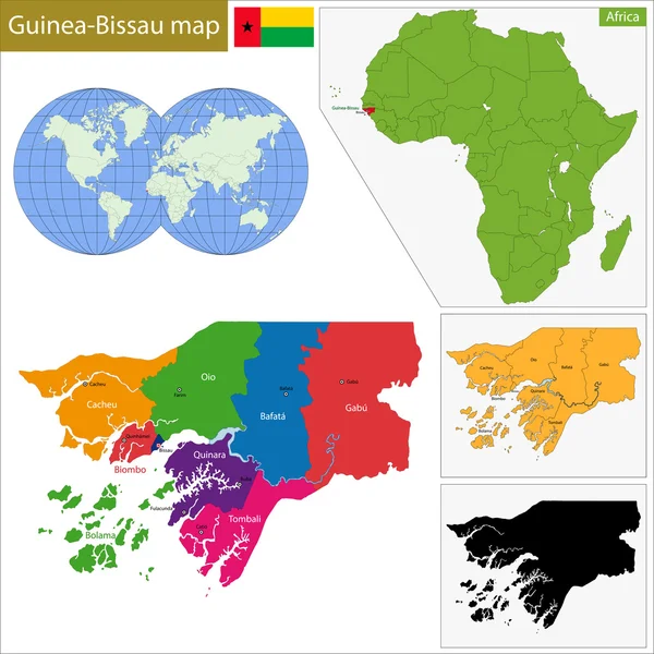
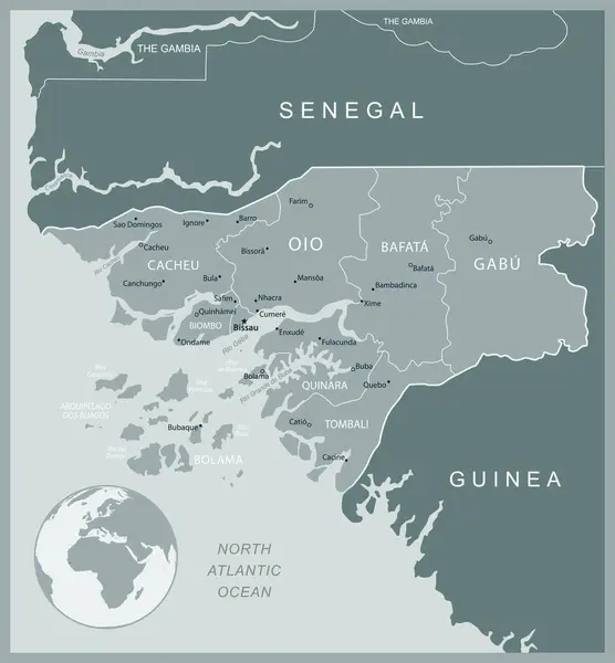
Tombali Region Map, Administrative Division Of Guinea Bissau. Vector Illustration.

Vector, 5.3MB, 8334 × 8334 eps
stock vector Locator map showing the location of the country Papua New Guinea in Australia. The country is highlighted with a red polygon. Small countries are also marked with a red circle. The map shows yellow land areas, blue sea, state borders and a blue grid

Locator Map Showing The Location Of The Country Papua New Guinea In Australia. The Country Is Highlighted With A Red Polygon. Small Countries Are Also Marked With A Red Circle. The Map Shows Yellow Land Areas, Blue Sea, State Borders And A Blue Grid

Vector, 3.33MB, 2400 × 2400 eps
stock vector high detailed australia city vector map

High Detailed Australia City Vector Map

Vector, 1.7MB, 5323 × 4263 eps
stock vector Papua New Guinea - detailed map with administrative divisions country. Vector illustration

Papua New Guinea - Detailed Map With Administrative Divisions Country. Vector Illustration

Vector, 2.76MB, 5405 × 5872 eps
stock vector New Ireland Province map, administrative division of Papua New Guinea. Vector illustration.

New Ireland Province Map, Administrative Division Of Papua New Guinea. Vector Illustration.

Vector, 6.58MB, 8334 × 8334 eps
stock vector Western Province map, administrative division of Papua New Guinea. Vector illustration.

Western Province Map, Administrative Division Of Papua New Guinea. Vector Illustration.

Vector, 6.58MB, 8334 × 8334 eps
stock vector Enga Province map, administrative division of Papua New Guinea. Vector illustration.

Enga Province Map, Administrative Division Of Papua New Guinea. Vector Illustration.

Vector, 5.33MB, 8334 × 8334 eps
stock vector Madang Province map, administrative division of Papua New Guinea. Vector illustration.

Madang Province Map, Administrative Division Of Papua New Guinea. Vector Illustration.

Vector, 5.38MB, 8334 × 8334 eps
stock vector Western Province map, administrative division of Papua New Guinea. Vector illustration.

Western Province Map, Administrative Division Of Papua New Guinea. Vector Illustration.

Vector, 5.43MB, 8334 × 8334 eps
stock vector Locator map showing the location of the country Guinea-Bissau in Africa. The country is highlighted with a red polygon. No labels at all. Made with Natural Earth.

Locator Map Showing The Location Of The Country Guinea-Bissau In Africa. The Country Is Highlighted With A Red Polygon. No Labels At All. Made With Natural Earth.

Vector, 1.14MB, 6660 × 5830 eps
stock vector Guinea-Bissau country detailed editable map

Guinea-Bissau Country Detailed Editable Map

Vector, 1.28MB, 5595 × 6000 eps
stock image Satellite globe map centered on Cameroun

Satellite Globe Map Centered On Cameroun

Image, 5.96MB, 3840 × 2160 jpg
stock vector indonesia administrative vector map with flag

Indonesia Administrative Vector Map With Flag

Vector, 2.42MB, 6972 × 3100 eps
stock vector New Ireland Province map, administrative division of Papua New Guinea. Vector illustration.

New Ireland Province Map, Administrative Division Of Papua New Guinea. Vector Illustration.

Vector, 5.45MB, 8334 × 8334 eps
stock vector Autonomous Region of Bougainville map, administrative division of Papua New Guinea. Vector illustration.

Autonomous Region Of Bougainville Map, Administrative Division Of Papua New Guinea. Vector Illustration.

Vector, 5.37MB, 8334 × 8334 eps
stock vector Cacheu region map, administrative division of Guinea Bissau. Vector illustration.

Cacheu Region Map, Administrative Division Of Guinea Bissau. Vector Illustration.

Vector, 5.3MB, 8334 × 8334 eps
stock vector Jiwaka Province map, administrative division of Papua New Guinea. Vector illustration.

Jiwaka Province Map, Administrative Division Of Papua New Guinea. Vector Illustration.

Vector, 6.58MB, 8334 × 8334 eps
stock vector East Sepik Province map, administrative division of Papua New Guinea. Vector illustration.

East Sepik Province Map, Administrative Division Of Papua New Guinea. Vector Illustration.

Vector, 6.58MB, 8334 × 8334 eps
stock vector Locator map showing the location of the country Guinea-Bissau in Africa. The country is highlighted with a red polygon. Small countries are also marked with a red circle. The map shows yellow land areas, blue sea, state borders and a blue grid lines.

Locator Map Showing The Location Of The Country Guinea-Bissau In Africa. The Country Is Highlighted With A Red Polygon. Small Countries Are Also Marked With A Red Circle. The Map Shows Yellow Land Areas, Blue Sea, State Borders And A Blue Grid Lines.

Vector, 4.9MB, 2400 × 2400 eps
stock vector Political Map of Oceania

Political Map Of Oceania

Vector, 6.01MB, 6000 × 4405 eps
stock vector western africa map with flags

Western Africa Map With Flags

Vector, 1.21MB, 4348 × 4108 eps
stock vector Guinea map

Guinea Map

Vector, 9.34MB, 7004 × 7004 eps
stock image Close-up of asatellite map centered on Liberia

Close-up Of Asatellite Map Centered On Liberia

Image, 6.4MB, 3840 × 2160 jpg
stock vector Guinea-Bissau - detailed map with administrative divisions country. Vector illustration

Guinea-Bissau - Detailed Map With Administrative Divisions Country. Vector Illustration

Vector, 1.31MB, 5420 × 5844 eps
stock vector Central Province map, administrative division of Papua New Guinea. Vector illustration.

Central Province Map, Administrative Division Of Papua New Guinea. Vector Illustration.

Vector, 5.4MB, 8334 × 8334 eps
stock vector Milne Bay Province map, administrative division of Papua New Guinea. Vector illustration.

Milne Bay Province Map, Administrative Division Of Papua New Guinea. Vector Illustration.

Vector, 5.61MB, 8334 × 8334 eps
stock vector National Capital District map, administrative division of Papua New Guinea. Vector illustration.

National Capital District Map, Administrative Division Of Papua New Guinea. Vector Illustration.

Vector, 5.32MB, 8334 × 8334 eps
stock vector Southern Highlands Province map, administrative division of Papua New Guinea. Vector illustration.

Southern Highlands Province Map, Administrative Division Of Papua New Guinea. Vector Illustration.

Vector, 5.33MB, 8334 × 8334 eps
Page 1 >> Next