photo free
Home Images Vectors Videos

Stock image Twin Falls Map

stock vector Word cloud map of Idaho state

Word Cloud Map Of Idaho State

Vector, 0.97MB, 4000 × 4000 eps
stock vector Idaho County Map

Idaho County Map

Vector, 0.62MB, 3333 × 5000 ai
stock vector Idaho, ID, political map with the capital Boise, borders, important cities, rivers and lakes. State in the Pacific Northwest region of the Western United States of America, nicknamed Gem State. Vector

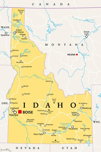
Idaho, ID, Political Map With The Capital Boise, Borders, Important Cities, Rivers And Lakes. State In The Pacific Northwest Region Of The Western United States Of America, Nicknamed Gem State. Vector

Vector, 3.64MB, 6000 × 9000 eps
stock vector Idaho County Map

Idaho County Map

Vector, 0.62MB, 3332 × 5000 ai
stock image idaho state cities list

Idaho State Cities List

Image, 12.86MB, 4055 × 2372 jpg
stock vector Idaho, U.S. state, subdivided into 44 counties, gray political map with borders and county names. State in the Mountain West region of the United States, nicknamed The Gem State, or The Potato State.

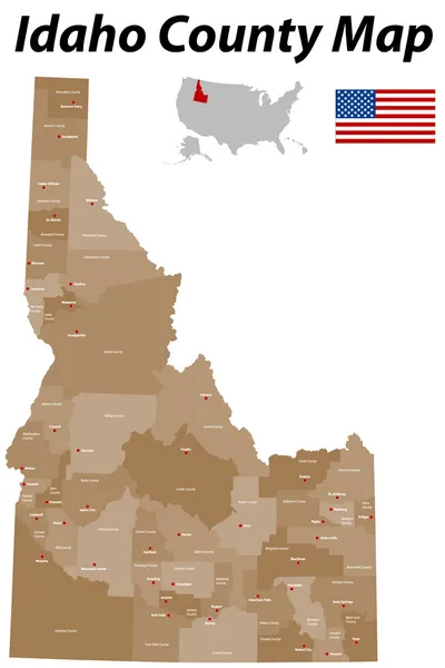
Idaho, U.S. State, Subdivided Into 44 Counties, Gray Political Map With Borders And County Names. State In The Mountain West Region Of The United States, Nicknamed The Gem State, Or The Potato State.

Vector, 2.32MB, 6000 × 8868 eps
stock vector IDAHO state map typography on black background.

IDAHO State Map Typography On Black Background.

Vector, 5.41MB, 6817 × 6827 eps
stock vector Idaho, U.S. state, subdivided into 44 counties, political map with borders and county names. State in the Mountain West region of the United States, nicknamed The Gem State, or The Potato State.

Idaho, U.S. State, Subdivided Into 44 Counties, Political Map With Borders And County Names. State In The Mountain West Region Of The United States, Nicknamed The Gem State, Or The Potato State.

Vector, 2.77MB, 6000 × 8115 eps
Page 1 >> Next