photo free
Home Images Vectors Videos

Stock image Wallis And Futuna Map

stock vector Pinned countries flags on map of Oceania

Pinned Countries Flags On Map Of Oceania

Vector, 0.53MB, 5156 × 2950 ai
stock vector Map markers with flags - Oceania. Original colors.

Map Markers With Flags - Oceania. Original Colors.

Vector, 5.12MB, 4000 × 7091 eps
stock vector Australian, Oceania Round Pointer Flag and map

Australian, Oceania Round Pointer Flag And Map

Vector, 6.96MB, 5000 × 5000 eps
stock vector Road map of the French overseas territory of Wallis and Futuna

Road Map Of The French Overseas Territory Of Wallis And Futuna

Vector, 1.02MB, 5078 × 3100 eps
stock vector Wallis and Futuna, France, french regional license plate template, detail of the side label of the department, vector illustration, example of numbering

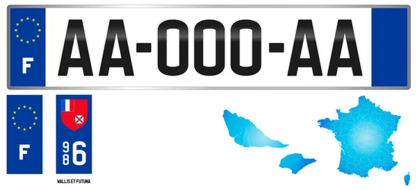
Wallis And Futuna, France, French Regional License Plate Template, Detail Of The Side Label Of The Department, Vector Illustration, Example Of Numbering

Vector, 6.39MB, 7027 × 3217 eps
stock vector Administrative map of the 13 regions of France and overseas territories

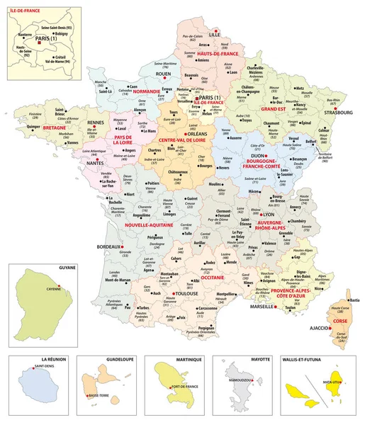
Administrative Map Of The 13 Regions Of France And Overseas Territories

Vector, 2.77MB, 3496 × 4071 eps
stock vector Oceania flags collection. Big set of blue pin icon with flags.

Oceania Flags Collection. Big Set Of Blue Pin Icon With Flags.

Vector, 1.16MB, 8000 × 4000 eps
stock vector national flags of the world

National Flags Of The World

Vector, 1.75MB, 7000 × 4666 eps
stock vector Wallis and Futuna, gray political map. Island collectivity of France in the South Pacific with capital Mata Utu, consisting of 3 main volcanic tropical islands Wallis, Futuna and uninhabited Alofi.

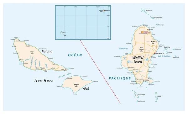
Wallis And Futuna, Gray Political Map. Island Collectivity Of France In The South Pacific With Capital Mata Utu, Consisting Of 3 Main Volcanic Tropical Islands Wallis, Futuna And Uninhabited Alofi.

Vector, 1.78MB, 8992 × 6000 eps
stock vector New Zealand and southern Polynesia, gray political map with capitals. Solomon Islands, Vanuatu, Fiji, Tonga, Samoa and New Caledonia. Islands in the South Pacific Ocean. English. Illustration. Vector.

New Zealand And Southern Polynesia, Gray Political Map With Capitals. Solomon Islands, Vanuatu, Fiji, Tonga, Samoa And New Caledonia. Islands In The South Pacific Ocean. English. Illustration. Vector.

Vector, 2.28MB, 6000 × 9000 eps
stock vector Wallis and Futuna. Islands in the South Pacific Ocean. Silhouette of the island state. Vector illustration.

Wallis And Futuna. Islands In The South Pacific Ocean. Silhouette Of The Island State. Vector Illustration.

Vector, 0.37MB, 5760 × 3297 eps
Page 1 >> Next