
Stock image Andreanof
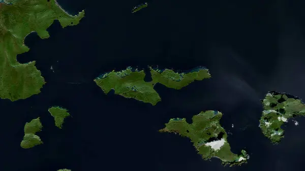
Igitkin Island In The Bering Sea On A Satellite Image Taken In September 24, 2019
Image, 4.36MB, 2880 × 1620 jpg

Little Tanaga Island In The Bering Sea On A Topographic, OSM Humanitarian Style Map
Image, 0.58MB, 2880 × 1620 jpg

Gareloi Island In The Bering Sea On A Satellite Image Taken In November 5, 2020
Image, 5.02MB, 2880 × 1620 jpg

Adak Island In The Bering Sea On A Topographic, OSM Humanitarian Style Map
Image, 0.85MB, 2880 × 1620 jpg

Great Sitkin Island In The Bering Sea - Belonging To United States. Described Location Diagram With Yellow Shape Of The Island And Sample Maps Of Its Surroundings
Image, 2.33MB, 3840 × 2160 jpg

Seguam Island In The Bering Sea, Belonging To United States, Isolated On A Topographic, OSM Humanitarian Style Map, With Distance Scale
Image, 0.26MB, 2160 × 2160 jpg

Adak Island In The Bering Sea - Belonging To United States. Described Location Diagram With Yellow Shape Of The Island And Sample Maps Of Its Surroundings
Image, 14.27MB, 11520 × 6480 jpg

Amlia Island In The Bering Sea, Belonging To United States, Isolated On A Satellite Image Taken In January 18, 2024, With Distance Scale
Image, 0.6MB, 2160 × 2160 jpg

Atka Island In The Bering Sea, Belonging To United States, Isolated On A Satellite Image Taken In June 17, 2023, With Distance Scale
Image, 0.66MB, 2160 × 2160 jpg

Chugul Island In The Bering Sea, Belonging To United States, Isolated On A Satellite Image Taken In October 28, 2023, With Distance Scale
Image, 0.96MB, 2160 × 2160 jpg

Seguam Island In The Bering Sea On A Satellite Image Taken In July 19, 2023
Image, 3.83MB, 2880 × 1620 jpg


Chugul Island In The Bering Sea - Belonging To United States. Described Location Diagram With Yellow Shape Of The Island And Sample Maps Of Its Surroundings
Image, 2.09MB, 3840 × 2160 jpg

Kagalaska Island In The Bering Sea On A Satellite Image Taken In September 24, 2019
Image, 5.59MB, 2880 × 1620 jpg

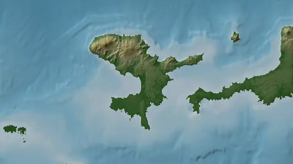
Tanaga Island In The Bering Sea On A Satellite Image Taken In September 13, 2021
Image, 3.82MB, 2880 × 1620 jpg

Seguam Island In The Bering Sea - Belonging To United States. Described Location Diagram With Yellow Shape Of The Island And Sample Maps Of Its Surroundings
Image, 1.88MB, 3840 × 2160 jpg

Amatignak Island In The North Pacific Ocean On A Topographic, OSM Humanitarian Style Map
Image, 0.31MB, 2880 × 1620 jpg

Amlia Island In The Bering Sea On A Topographic, OSM Humanitarian Style Map
Image, 0.57MB, 2880 × 1620 jpg

Amatignak Island In The North Pacific Ocean, Belonging To United States, Isolated On A Topographic, OSM Humanitarian Style Map, With Distance Scale
Image, 0.34MB, 2160 × 2160 jpg

Gareloi Island In The Bering Sea On A Topographic, OSM Humanitarian Style Map
Image, 0.28MB, 2880 × 1620 jpg

Atka Island In The Bering Sea - Belonging To United States. Described Location Diagram With Yellow Shape Of The Island And Sample Maps Of Its Surroundings
Image, 2.01MB, 3840 × 2160 jpg

Great Sitkin Island In The Bering Sea, Belonging To United States, Isolated On A Topographic, OSM Humanitarian Style Map, With Distance Scale
Image, 0.33MB, 2160 × 2160 jpg

Little Tanaga Island In The Bering Sea On A Satellite Image Taken In September 24, 2019
Image, 4.71MB, 2880 × 1620 jpg

Umak Island In The Bering Sea, Belonging To United States, Isolated On A Bilevel Elevation Map, With Distance Scale
Image, 0.32MB, 2160 × 2160 jpg

Amlia Island In The Bering Sea - Belonging To United States. Described Location Diagram With Yellow Shape Of The Island And Sample Maps Of Its Surroundings
Image, 1.97MB, 3840 × 2160 jpg

Atka Island In The Bering Sea, Belonging To United States, Isolated On A Bilevel Elevation Map, With Distance Scale
Image, 0.39MB, 2160 × 2160 jpg

Little Tanaga Island In The Bering Sea - Belonging To United States. Described Location Diagram With Yellow Shape Of The Island And Sample Maps Of Its Surroundings
Image, 2.4MB, 3840 × 2160 jpg

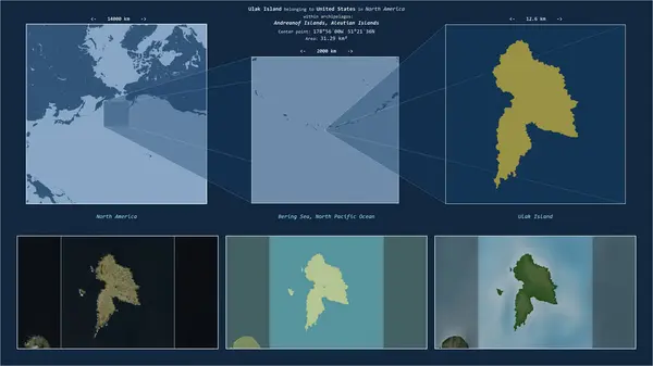
Ulak Island In The Bering Sea - Belonging To United States. Described Location Diagram With Yellow Shape Of The Island And Sample Maps Of Its Surroundings
Image, 1.99MB, 3840 × 2160 jpg

Great Sitkin Island In The Bering Sea On A Topographic, OSM Humanitarian Style Map
Image, 0.4MB, 2880 × 1620 jpg


Great Sitkin Island In The Bering Sea On A Satellite Image Taken In September 24, 2019
Image, 4.28MB, 2880 × 1620 jpg

Kagalaska Island In The Bering Sea On A Topographic, OSM Humanitarian Style Map
Image, 0.79MB, 2880 × 1620 jpg
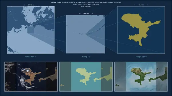
Tanaga Island In The Bering Sea - Belonging To United States. Described Location Diagram With Yellow Shape Of The Island And Sample Maps Of Its Surroundings
Image, 2.31MB, 3840 × 2160 jpg

Umak Island In The Bering Sea, Belonging To United States, Isolated On A Satellite Image Taken In November 23, 2017, With Distance Scale
Image, 1.17MB, 2160 × 2160 jpg

Seguam Island In The Bering Sea, Belonging To United States, Isolated On A Satellite Image Taken In October 17, 2020, With Distance Scale
Image, 1.48MB, 2160 × 2160 jpg


Umak Island In The Bering Sea On A Satellite Image Taken In September 24, 2019
Image, 4.31MB, 2880 × 1620 jpg

Seguam Island In The Bering Sea, Belonging To United States, Isolated On A Bilevel Elevation Map, With Distance Scale
Image, 0.45MB, 2160 × 2160 jpg
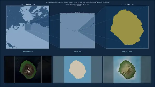
Gareloi Island In The Bering Sea - Belonging To United States. Described Location Diagram With Yellow Shape Of The Island And Sample Maps Of Its Surroundings
Image, 2.12MB, 3840 × 2160 jpg

Great Sitkin Island In The Bering Sea, Belonging To United States, Isolated On A Bilevel Elevation Map, With Distance Scale
Image, 0.47MB, 2160 × 2160 jpg

Adak Island In The Bering Sea, Belonging To United States, Isolated On A Satellite Image Taken In November 23, 2017, With Distance Scale
Image, 1.79MB, 2160 × 2160 jpg

Kagalaska Island In The Bering Sea, Belonging To United States, Isolated On A Bilevel Elevation Map, With Distance Scale
Image, 0.43MB, 2160 × 2160 jpg

Amlia Island In The Bering Sea, Belonging To United States, Isolated On A Bilevel Elevation Map, With Distance Scale
Image, 0.31MB, 2160 × 2160 jpg


Kanaga Island In The Bering Sea, Belonging To United States, Isolated On A Topographic, OSM Humanitarian Style Map, With Distance Scale
Image, 0.31MB, 2160 × 2160 jpg
Page 1 >> Next