photo free
Home Images Vectors Videos

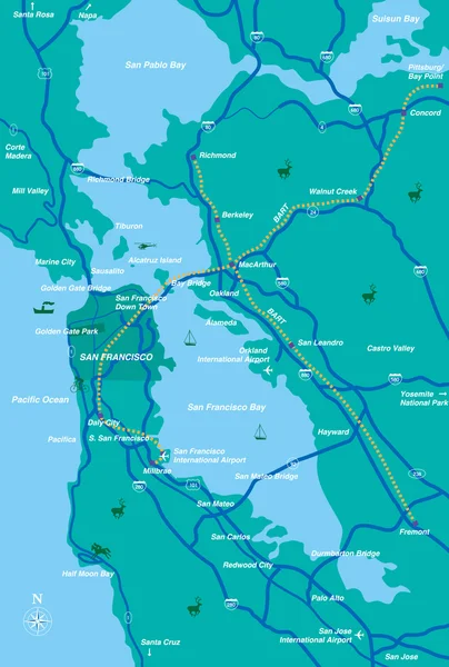
Stock image Bay Area Map

stock vector San Francisco Bay Area Map

San Francisco Bay Area Map

Vector, 1.53MB, 3371 × 5000 eps
stock vector Administrative map of the California region San Francisco Bay Area

Administrative Map Of The California Region San Francisco Bay Area

Vector, 0.74MB, 3100 × 3189 eps
stock vector Administrative and road map of the California region San Francisco Bay Area

Administrative And Road Map Of The California Region San Francisco Bay Area

Vector, 1.55MB, 3100 × 3189 eps
stock vector Metro Manila administrative, political and road map, Philippines

Metro Manila Administrative, Political And Road Map, Philippines

Vector, 1.02MB, 3100 × 4963 eps
stock vector Tokyo bay area road map ( with place names, sightseeing spots)

Tokyo Bay Area Road Map ( With Place Names, Sightseeing Spots)

Vector, 1.44MB, 4481 × 4185 eps
stock vector Tokyo bay area road map

Tokyo Bay Area Road Map

Vector, 1.16MB, 4481 × 4184 eps
stock vector San Francisco Bay Area, region of the U.S. state California, gray political map with counties and largest cities. Area that surrounds and include the San Francisco Bay, which is a large tidal estuary.

San Francisco Bay Area, Region Of The U.S. State California, Gray Political Map With Counties And Largest Cities. Area That Surrounds And Include The San Francisco Bay, Which Is A Large Tidal Estuary.

Vector, 3.29MB, 6000 × 6000 eps
stock vector Silicon Valley, a region in Northern California, political map. Global center for high technology and innovation in the United States, located in the southern part of the San Francisco Bay Area.

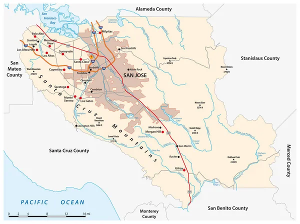
Silicon Valley, A Region In Northern California, Political Map. Global Center For High Technology And Innovation In The United States, Located In The Southern Part Of The San Francisco Bay Area.

Vector, 2.32MB, 6000 × 6000 eps
stock vector Subregions of the San Francisco Bay Area, divided by counties, political map. Area of the U.S. state of California, that surrounds and includes the San Francisco Bay, which is a large tidal estuary.

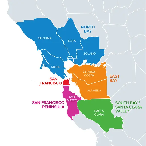
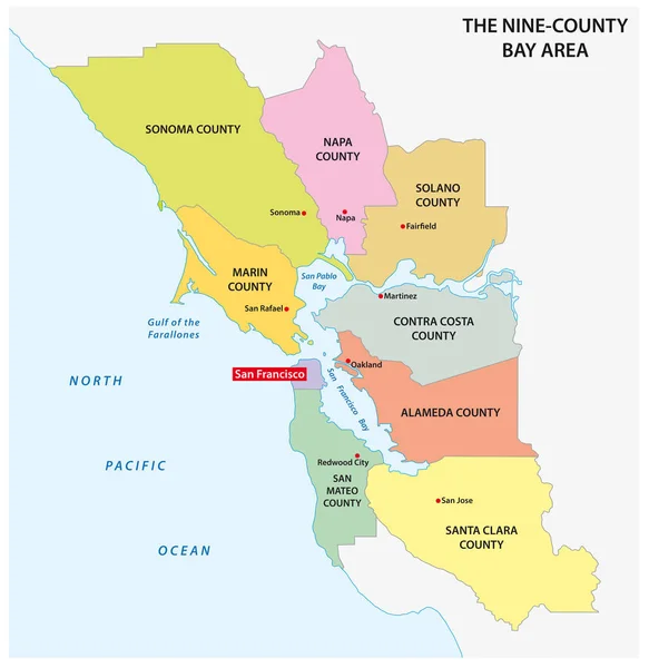
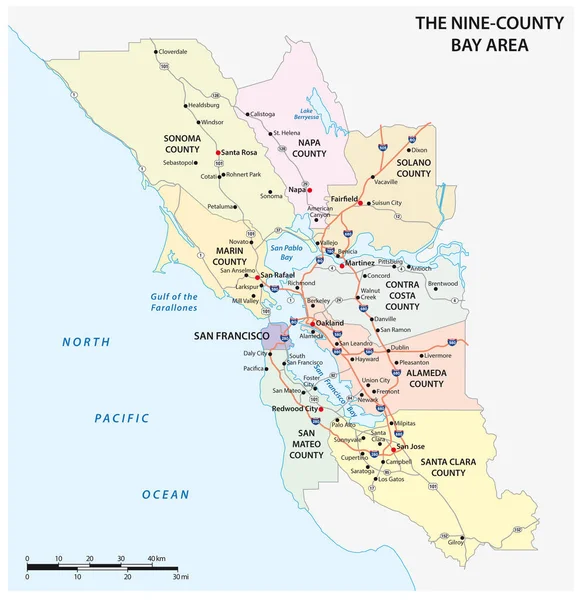
Subregions Of The San Francisco Bay Area, Divided By Counties, Political Map. Area Of The U.S. State Of California, That Surrounds And Includes The San Francisco Bay, Which Is A Large Tidal Estuary.

Vector, 2.94MB, 6000 × 6000 eps
stock vector California, major regions, political map. State in the Western United States with capital Sacramento, lying on the Pacific Coast. Valleys, coast regions, San Francisco Bay Area and the desert region.

California, Major Regions, Political Map. State In The Western United States With Capital Sacramento, Lying On The Pacific Coast. Valleys, Coast Regions, San Francisco Bay Area And The Desert Region.

Vector, 2.53MB, 6000 × 7143 eps
stock vector San Francisco Bay Area, a region of the U.S. state California, political map with counties and largest cities. An area that surrounds and include the San Francisco Bay, which is a large tidal estuary.

San Francisco Bay Area, A Region Of The U.S. State California, Political Map With Counties And Largest Cities. An Area That Surrounds And Include The San Francisco Bay, Which Is A Large Tidal Estuary.

Vector, 3.73MB, 6000 × 6000 eps
stock vector State of California counties, political map. U.S. state of California, subdivided into 58 counties, with San Bernardino County as largest and Los Angeles County as most populous in the United States.

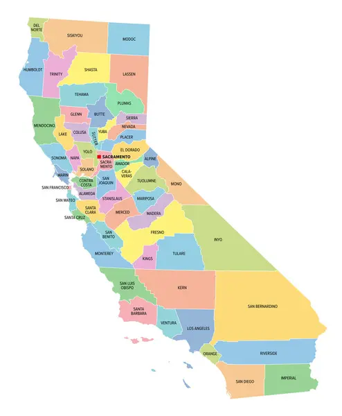
State Of California Counties, Political Map. U.S. State Of California, Subdivided Into 58 Counties, With San Bernardino County As Largest And Los Angeles County As Most Populous In The United States.

Vector, 3.13MB, 6000 × 7108 eps
stock vector vector road map of California Santa Clara County, United States

Vector Road Map Of California Santa Clara County, United States

Vector, 1.41MB, 4146 × 3100 eps
stock vector California, U.S. state, multi colored political map with borders, county names and its capital Sacramento. State in the Western United States on the Pacific Coast, subdivided into 58 counties.

California, U.S. State, Multi Colored Political Map With Borders, County Names And Its Capital Sacramento. State In The Western United States On The Pacific Coast, Subdivided Into 58 Counties.

Vector, 2.85MB, 6000 × 7279 eps
stock vector Detailed vector map of Tokyo, Japan

Detailed Vector Map Of Tokyo, Japan

Vector, 30.65MB, 4200 × 3000 eps
stock vector Silicon Valley, a region in Northern California, gray political map. Global center for high technology and innovation in the United States, located in the southern part of the San Francisco Bay Area.

Silicon Valley, A Region In Northern California, Gray Political Map. Global Center For High Technology And Innovation In The United States, Located In The Southern Part Of The San Francisco Bay Area.

Vector, 2.1MB, 6000 × 6000 eps
stock vector Silicon Valley, a region in Northern California, dark political map. Global center for high technology and innovation in the United States, located in the southern part of the San Francisco Bay Area.

Silicon Valley, A Region In Northern California, Dark Political Map. Global Center For High Technology And Innovation In The United States, Located In The Southern Part Of The San Francisco Bay Area.

Vector, 2.06MB, 6000 × 6000 eps
stock vector California state counties, gray political map. U.S. state of California subdivided into 58 counties, with San Bernardino County as largest and Los Angeles County as most populous in the United States.

California State Counties, Gray Political Map. U.S. State Of California Subdivided Into 58 Counties, With San Bernardino County As Largest And Los Angeles County As Most Populous In The United States.

Vector, 2.83MB, 6000 × 7279 eps
stock vector Abstarct Map of Coastal Town Area. Vector Design

Abstarct Map Of Coastal Town Area. Vector Design

Vector, 2.3MB, 4167 × 4167 eps
stock vector map of the city of Reykjavik, Capital Region, Iceland

Map Of The City Of Reykjavik, Capital Region, Iceland

Vector, 4.03MB, 7016 × 4323 eps
stock vector illustration map of the city of Reykjavik, Capital Region, Iceland

Illustration Map Of The City Of Reykjavik, Capital Region, Iceland

Vector, 4.39MB, 6623 × 4961 eps
stock vector Vector map of the city of Dublin, Ireland

Vector Map Of The City Of Dublin, Ireland

Vector, 11.37MB, 6949 × 4679 eps
stock vector Urban vector city map of Tampa, Florida, United States of America

Urban Vector City Map Of Tampa, Florida, United States Of America

Vector, 4.22MB, 6000 × 3110 eps
stock vector Vector map of the city of Dublin, Ireland

Vector Map Of The City Of Dublin, Ireland

Vector, 9.91MB, 6618 × 4923 eps
stock vector map of the city of Reykjavik, Capital Region, Iceland

Map Of The City Of Reykjavik, Capital Region, Iceland

Vector, 2.77MB, 6934 × 3238 eps
stock image Las Vegas on Google Map

Las Vegas On Google Map

Image, 18.68MB, 5267 × 3382 jpg
stock vector Vector map of the city of Dublin, Ireland

Vector Map Of The City Of Dublin, Ireland

Vector, 11.36MB, 6950 × 4679 eps
stock vector ������������

������������

Vector, 2.53MB, 5000 × 5000 eps
stock vector Map of the roads and neighborhoods of new york borough brooklyn

Map Of The Roads And Neighborhoods Of New York Borough Brooklyn

Vector, 1.42MB, 3100 × 3501 eps
stock vector Main road and administrative map of Greater Rio de Janeiro, Brazil

Main Road And Administrative Map Of Greater Rio De Janeiro, Brazil

Vector, 1.16MB, 4749 × 3100 eps
stock vector illustration map of the city of Reykjavik, Capital Region, Iceland

Illustration Map Of The City Of Reykjavik, Capital Region, Iceland

Vector, 3.64MB, 6934 × 3239 eps
stock image San Francisco top view vintage illustration

San Francisco Top View Vintage Illustration

Image, 21.6MB, 4767 × 3434 jpg
stock vector Shanghai and the Yangtze River Delta, political map with major cities. Megalopolis of China, located where the Yangtze River drains into the East China Sea, with Hangzhou Bay and Zhoushan Archipelago.

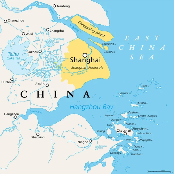
Shanghai And The Yangtze River Delta, Political Map With Major Cities. Megalopolis Of China, Located Where The Yangtze River Drains Into The East China Sea, With Hangzhou Bay And Zhoushan Archipelago.

Vector, 5.05MB, 6000 × 6000 eps
stock vector Map of the gulf of naples in italian language

Map Of The Gulf Of Naples In Italian Language

Vector, 1.26MB, 4028 × 3100 eps
stock image Las Vegas on Google Map

Las Vegas On Google Map

Image, 18.38MB, 6016 × 4000 jpg
stock vector Baltimore on Maryland State Map. Detailed MD State Map with Location Pin on Baltimore City. Black silhouette vector map isolated on white background.

Baltimore On Maryland State Map. Detailed MD State Map With Location Pin On Baltimore City. Black Silhouette Vector Map Isolated On White Background.

Vector, 5.73MB, 8334 × 8334 eps
stock vector administrative and political map of the greater Rio de Janeiro

Administrative And Political Map Of The Greater Rio De Janeiro

Vector, 1.21MB, 5791 × 3100 eps
stock vector Brooklyn map poster. New York city borough street map. Cityscape aria panorama silhouette aerial view, typography style. Jamaica Bay, the Atlantic Ocean, The Narrows, Upper New York Bay.

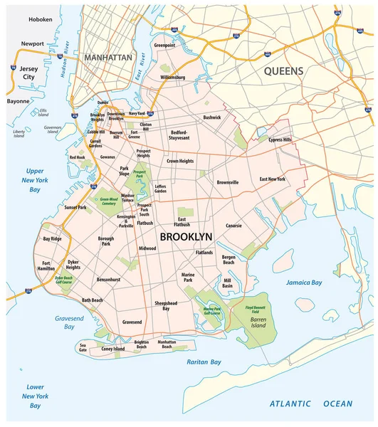
Brooklyn Map Poster. New York City Borough Street Map. Cityscape Aria Panorama Silhouette Aerial View, Typography Style. Jamaica Bay, The Atlantic Ocean, The Narrows, Upper New York Bay.

Vector, 2.95MB, 4510 × 3822 eps
stock vector Wisconsin, WI, political map, with the capital Madison and metropolitan area Milwaukee. State in the upper Midwestern United States of America, with the nicknames Badger State, and Americas Dairyland.

Wisconsin, WI, Political Map, With The Capital Madison And Metropolitan Area Milwaukee. State In The Upper Midwestern United States Of America, With The Nicknames Badger State, And Americas Dairyland.

Vector, 4.43MB, 6000 × 6000 eps
stock vector Shanghai and the Yangtze River Delta, gray political map, with major cities. Megalopolis of China, located where Yangtze River drains into East China Sea, with Hangzhou Bay and Zhoushan Archipelago.

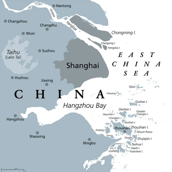
Shanghai And The Yangtze River Delta, Gray Political Map, With Major Cities. Megalopolis Of China, Located Where Yangtze River Drains Into East China Sea, With Hangzhou Bay And Zhoushan Archipelago.

Vector, 3.21MB, 6000 × 6000 eps
stock vector roads and national parks map of the european island nation of iceland

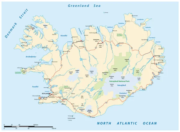
Roads And National Parks Map Of The European Island Nation Of Iceland

Vector, 2.3MB, 4246 × 3100 eps
stock vector outline and silhouette map of Canada - vector illustration hand drawn with black lines, isolated on white background

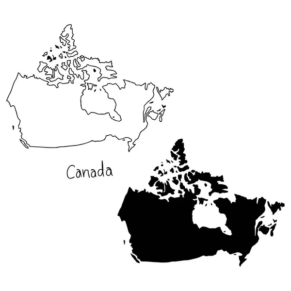
Outline And Silhouette Map Of Canada - Vector Illustration Hand Drawn With Black Lines, Isolated On White Background

Vector, 5.5MB, 5000 × 5000 eps
stock vector outline and silhouette map of Hong Kong - vector illustration hand drawn with black lines, isolated on white background

Outline And Silhouette Map Of Hong Kong - Vector Illustration Hand Drawn With Black Lines, Isolated On White Background

Vector, 5.68MB, 5000 × 5000 eps
stock vector vector map of the Indian archipelago of the Andaman Islands

Vector Map Of The Indian Archipelago Of The Andaman Islands

Vector, 1.62MB, 3100 × 4446 eps
stock vector Warsaw city map in gray on a white background

Warsaw City Map In Gray On A White Background

Vector, 0.75MB, 4167 × 4167 eps
stock image Driving using navigation system, Golden Gate Bridge, San Francisco, USA

Driving Using Navigation System, Golden Gate Bridge, San Francisco, USA

Image, 3.21MB, 3000 × 1947 jpg
stock vector road and national park map of the Northern Territory, Australia

Road And National Park Map Of The Northern Territory, Australia

Vector, 1.65MB, 3100 × 4804 eps
stock vector Republic of India vector map

Republic Of India Vector Map

Vector, 1.44MB, 3245 × 3704 eps
stock vector Map of India with the biggest cities and rivers

Map Of India With The Biggest Cities And Rivers

Vector, 2.4MB, 3435 × 4073 eps
stock vector vector map of the Indian archipelago of the Andaman Islands

Vector Map Of The Indian Archipelago Of The Andaman Islands

Vector, 1.06MB, 3100 × 4446 eps
Page 1 >> Next