photo free
Home Images Vectors Videos

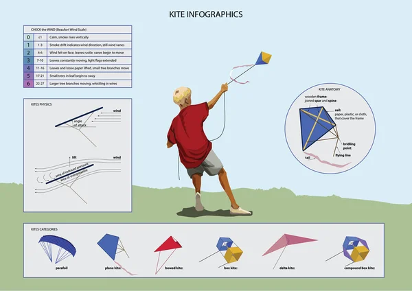
Stock image Beaufort Scale

stock vector Beaufort wind scale vector illustration. Labeled air energy strength scheme

Beaufort Wind Scale Vector Illustration. Labeled Air Energy Strength Scheme

Vector, 7.66MB, 4000 × 4320 eps
stock vector Set of Kites Inf-ographic Elements

Set Of Kites Inf-ographic Elements

Vector, 1.88MB, 4243 × 3000 eps
stock image Summer Storm over the Great Mew Stone

Summer Storm Over The Great Mew Stone

Image, 3.24MB, 5020 × 3347 jpg
stock image Prince Patrick Island in the Beaufort Sea, belonging to Canada, isolated on a bilevel elevation map, with distance scale

Prince Patrick Island In The Beaufort Sea, Belonging To Canada, Isolated On A Bilevel Elevation Map, With Distance Scale

Image, 0.63MB, 2160 × 2160 jpg
stock image Prince Patrick Island in the Beaufort Sea - belonging to Canada. Described location diagram with yellow shape of the island and sample maps of its surroundings

Prince Patrick Island In The Beaufort Sea - Belonging To Canada. Described Location Diagram With Yellow Shape Of The Island And Sample Maps Of Its Surroundings

Image, 2.4MB, 3840 × 2160 jpg
stock image Prince Patrick Island in the Beaufort Sea, belonging to Canada, isolated on a satellite image taken in October 5, 2017, with distance scale

Prince Patrick Island In The Beaufort Sea, Belonging To Canada, Isolated On A Satellite Image Taken In October 5, 2017, With Distance Scale

Image, 1.71MB, 2160 × 2160 jpg
stock image Prince Patrick Island in the Beaufort Sea, belonging to Canada, isolated on a topographic, OSM Humanitarian style map, with distance scale

Prince Patrick Island In The Beaufort Sea, Belonging To Canada, Isolated On A Topographic, OSM Humanitarian Style Map, With Distance Scale

Image, 0.41MB, 2160 × 2160 jpg
Page 1 >> Next