photo free
Home Images Vectors Videos

Stock image Cartographic

stock image Peru area on the satellite C map in the stereographic projection - raw composition of raster layers with dark glowing outline

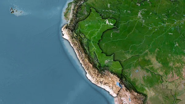
Peru Area On The Satellite C Map In The Stereographic Projection - Raw Composition Of Raster Layers With Dark Glowing Outline

Image, 5.94MB, 2880 × 1620 jpg
stock image Mean temperature of warmest quarter within the New Caledonia area in the stereographic projection with legend - main composition

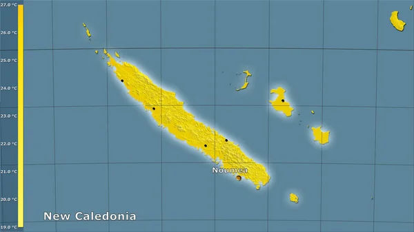
Mean Temperature Of Warmest Quarter Within The New Caledonia Area In The Stereographic Projection With Legend - Main Composition

Image, 1.15MB, 2880 × 1620 jpg
stock image New Zealand. Globe with the shape of the country against zoomed map with its outline isolated on the blue background. shapes only - land/ocean mask

New Zealand. Globe With The Shape Of The Country Against Zoomed Map With Its Outline Isolated On The Blue Background. Shapes Only - Land/ocean Mask

Image, 1.4MB, 2880 × 1620 jpg
stock image Zoomed-in view of Zimbabwe outline with perspective lines against a global map in the Kavrayskiy projection. Shape centered. satellite imagery

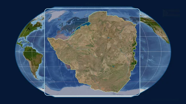
Zoomed-in View Of Zimbabwe Outline With Perspective Lines Against A Global Map In The Kavrayskiy Projection. Shape Centered. Satellite Imagery

Image, 3.11MB, 2880 × 1620 jpg
stock image World map in the Van Der Grinten projection centered on 11 East longitude. Bilevel topographic map - raw composite of raster with graticule. 3D illustration

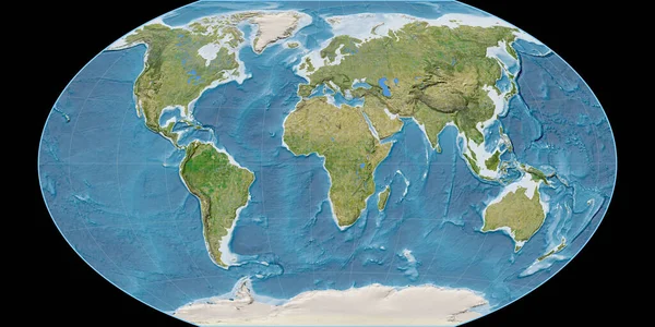
World Map In The Van Der Grinten Projection Centered On 11 East Longitude. Bilevel Topographic Map - Raw Composite Of Raster With Graticule. 3D Illustration

Image, 2.1MB, 4000 × 2000 jpg
stock image World map in the Winkel Tripel projection centered on 11 East longitude. Satellite imagery B - raw composite of raster with graticule. 3D illustration

World Map In The Winkel Tripel Projection Centered On 11 East Longitude. Satellite Imagery B - Raw Composite Of Raster With Graticule. 3D Illustration

Image, 9.18MB, 4000 × 2000 jpg
stock image Brazil. Globe with the shape of the country against zoomed map with its outline isolated on the blue background. shapes only - land/ocean mask

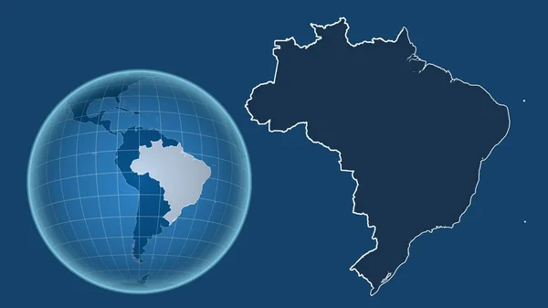
Brazil. Globe With The Shape Of The Country Against Zoomed Map With Its Outline Isolated On The Blue Background. Shapes Only - Land/ocean Mask

Image, 1.05MB, 2880 × 1620 jpg
stock image World map in the Braun Stereographic projection centered on 11 East longitude. Mean annual temperature map - raw composite of raster with graticule. 3D illustration

World Map In The Braun Stereographic Projection Centered On 11 East Longitude. Mean Annual Temperature Map - Raw Composite Of Raster With Graticule. 3D Illustration

Image, 3.4MB, 4000 × 2000 jpg
stock vector Pixel Austria Map

Pixel Austria Map

Vector, 0.3MB, 5479 × 2925 eps
stock vector Dot Moscow Oblast Map

Dot Moscow Oblast Map

Vector, 0.26MB, 4571 × 4296 eps
stock vector Stylized Africa map with indigenous animals and nature symbols. Simple geographical map. Flat vector illustration

Stylized Africa Map With Indigenous Animals And Nature Symbols. Simple Geographical Map. Flat Vector Illustration

Vector, 1.87MB, 5271 × 4743 eps
stock vector Cartographic pattern - vector illustration

Cartographic Pattern - Vector Illustration

Vector, 2.47MB, 4724 × 4724 eps
stock vector Cartographic pattern - vector illustration

Cartographic Pattern - Vector Illustration

Vector, 2.02MB, 4724 × 4724 eps
stock image Afghanistan. Close-up perspective of the country - no outline. satellite imagery

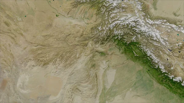
Afghanistan. Close-up Perspective Of The Country - No Outline. Satellite Imagery

Image, 5.39MB, 2880 × 1620 jpg
stock image Tajikistan area on the satellite B map in the stereographic projection - raw composition of raster layers with light glowing outline

Tajikistan Area On The Satellite B Map In The Stereographic Projection - Raw Composition Of Raster Layers With Light Glowing Outline

Image, 6.35MB, 2880 × 1620 jpg
stock image Mexico and its neighborhood. Distant oblique perspective - shape outlined. color physical map

Mexico And Its Neighborhood. Distant Oblique Perspective - Shape Outlined. Color Physical Map

Image, 3.59MB, 2880 × 1620 jpg
stock image Tajikistan area on the topographic relief map in the stereographic projection - raw composition of raster layers with light glowing outline

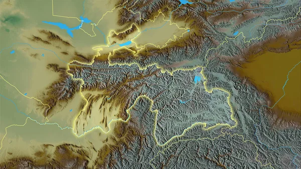
Tajikistan Area On The Topographic Relief Map In The Stereographic Projection - Raw Composition Of Raster Layers With Light Glowing Outline

Image, 7.08MB, 2880 × 1620 jpg
stock image Enlarged area of South Korea surrounded by a circle on the background of its neighborhood. Color physical map

Enlarged Area Of South Korea Surrounded By A Circle On The Background Of Its Neighborhood. Color Physical Map

Image, 2.85MB, 2880 × 1620 jpg
stock image Spain area on the annual precipitation map in the stereographic projection - raw composition of raster layers with dark glowing outline

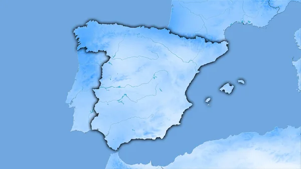
Spain Area On The Annual Precipitation Map In The Stereographic Projection - Raw Composition Of Raster Layers With Dark Glowing Outline

Image, 1.67MB, 2880 × 1620 jpg
stock image New Caledonia area on the satellite A map in the stereographic projection - raw composition of raster layers with light glowing outline

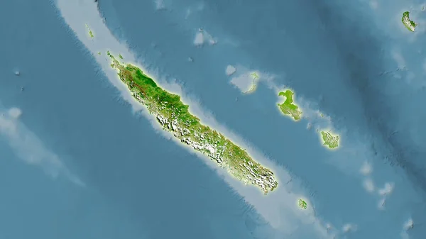
New Caledonia Area On The Satellite A Map In The Stereographic Projection - Raw Composition Of Raster Layers With Light Glowing Outline

Image, 2.19MB, 2880 × 1620 jpg
stock image Office stationery and magnifying glass on cadastral maps of territory with buildings

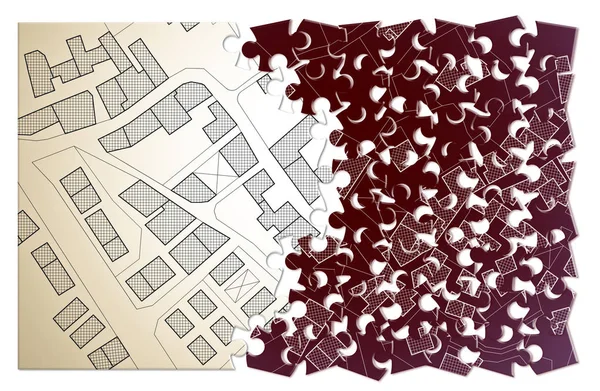
Office Stationery And Magnifying Glass On Cadastral Maps Of Territory With Buildings

Image, 7.16MB, 5760 × 3840 jpg
stock vector Blank political map of Europe. 3D Earth globe with colored map. Vector illustration

Blank Political Map Of Europe. 3D Earth Globe With Colored Map. Vector Illustration

Vector, 8.53MB, 6000 × 6000 eps
stock image Close-up Of A Businessperson Analyzing Cadastre Map On Computer In The Office

Close-up Of A Businessperson Analyzing Cadastre Map On Computer In The Office

Image, 15.45MB, 7564 × 5044 jpg
stock image Ethiopia area on the satellite A map in the stereographic projection - raw composition of raster layers

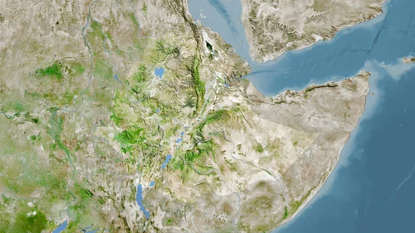
Ethiopia Area On The Satellite A Map In The Stereographic Projection - Raw Composition Of Raster Layers

Image, 6.57MB, 2880 × 1620 jpg
stock image World map in the Gall Stereographic projection centered on 11 East longitude. Colored shader, elevation map - raw composite of raster with graticule. 3D illustration

World Map In The Gall Stereographic Projection Centered On 11 East Longitude. Colored Shader, Elevation Map - Raw Composite Of Raster With Graticule. 3D Illustration

Image, 7.47MB, 4000 × 2000 jpg
stock image Guatemala and its neighborhood. Distant oblique perspective - shape outlined. satellite imagery

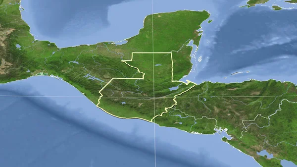
Guatemala And Its Neighborhood. Distant Oblique Perspective - Shape Outlined. Satellite Imagery

Image, 3.05MB, 2880 × 1620 jpg
stock image Spain area on the satellite C map in the stereographic projection - raw composition of raster layers

Spain Area On The Satellite C Map In The Stereographic Projection - Raw Composition Of Raster Layers

Image, 5.47MB, 2880 × 1620 jpg
stock image Malawi area on the satellite D map in the stereographic projection - main composition

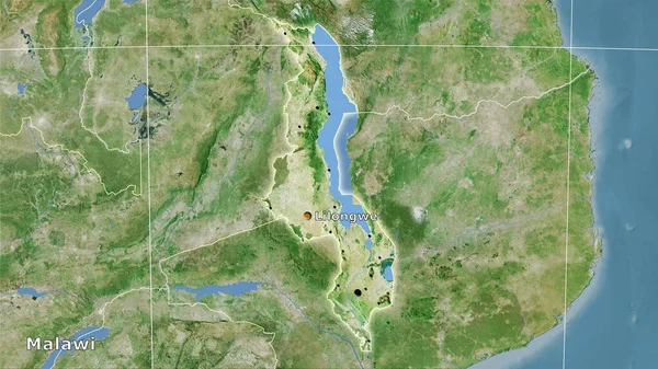
Malawi Area On The Satellite D Map In The Stereographic Projection - Main Composition

Image, 6.84MB, 2880 × 1620 jpg
stock image Romania area on the satellite A map in the stereographic projection - main composition

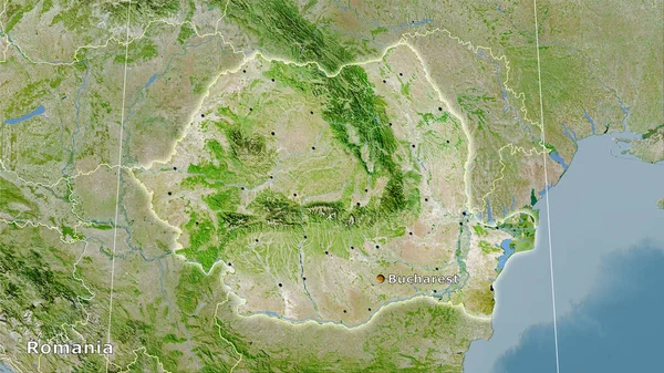
Romania Area On The Satellite A Map In The Stereographic Projection - Main Composition

Image, 7.64MB, 2880 × 1620 jpg
stock image Madaba, Jordan: the Madaba Mosaic Map, a map with hills, valleys and towns in Palestine and the Nile Delta dating from the 6th century on the floor of the Greek Orthodox Basilica of Saint George

Madaba, Jordan: The Madaba Mosaic Map, A Map With Hills, Valleys And Towns In Palestine And The Nile Delta Dating From The 6th Century On The Floor Of The Greek Orthodox Basilica Of Saint George

Image, 12.61MB, 4288 × 2848 jpg
stock image Office stationery and cadastral maps of territory with buildings on table

Office Stationery And Cadastral Maps Of Territory With Buildings On Table

Image, 7.46MB, 5760 × 3840 jpg
stock vector Map illustration of Ukraine with the flag. Cartographic illustration of Ukraine and neighboring countries.

Map Illustration Of Ukraine With The Flag. Cartographic Illustration Of Ukraine And Neighboring Countries.

Vector, 2.77MB, 6000 × 4000 eps
stock image Cadastral reform concept image with an imaginary cadastral map o

Cadastral Reform Concept Image With An Imaginary Cadastral Map O

Image, 8.18MB, 5476 × 3570 jpg
stock image World map in the Gall Stereographic projection centered on 11 East longitude. Main physiographic landscape features - raw composite of raster with graticule. 3D illustration

World Map In The Gall Stereographic Projection Centered On 11 East Longitude. Main Physiographic Landscape Features - Raw Composite Of Raster With Graticule. 3D Illustration

Image, 7.6MB, 4000 × 2000 jpg
stock image Taiwan area on the satellite B map in the stereographic projection - raw composition of raster layers

Taiwan Area On The Satellite B Map In The Stereographic Projection - Raw Composition Of Raster Layers

Image, 3.08MB, 2880 × 1620 jpg
stock image Topographic 3D map of dangerous mountain terrain. Contour lines on a topographic map. Studying geography of area: hills, mountains and plains. Cartography concept, mountain hiking. 3d illustration

Topographic 3D Map Of Dangerous Mountain Terrain. Contour Lines On A Topographic Map. Studying Geography Of Area: Hills, Mountains And Plains. Cartography Concept, Mountain Hiking. 3d Illustration

Image, 12.68MB, 8000 × 4500 jpg
stock image Close-up Of Human Hand Holding Pencil Over Paper Cadastre Map

Close-up Of Human Hand Holding Pencil Over Paper Cadastre Map

Image, 15.91MB, 9504 × 6336 jpg
stock vector A blue cartographic compass rose

A Blue Cartographic Compass Rose

Vector, 5.54MB, 8334 × 8335 eps
stock image Zoomed-in view of Congo Kinshasa outline with perspective lines against a global map in the Mollweide projection. Shape on the left side. satellite imagery

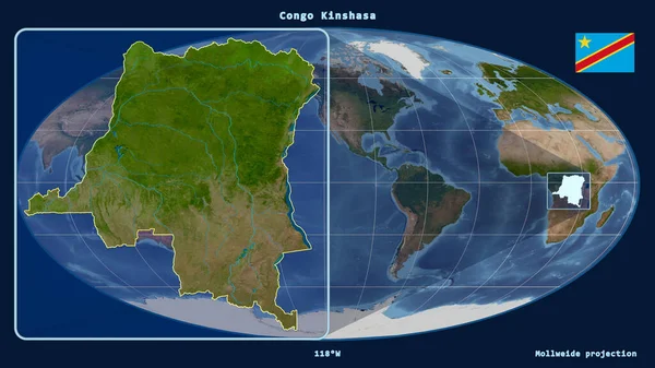
Zoomed-in View Of Congo Kinshasa Outline With Perspective Lines Against A Global Map In The Mollweide Projection. Shape On The Left Side. Satellite Imagery

Image, 3.24MB, 2880 × 1620 jpg
stock image Colombia area on the satellite D map in the stereographic projection - raw composition of raster layers with light glowing outline

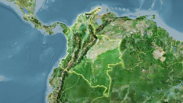
Colombia Area On The Satellite D Map In The Stereographic Projection - Raw Composition Of Raster Layers With Light Glowing Outline

Image, 6.11MB, 2880 × 1620 jpg
stock image Sweden area on the topographic relief map in the stereographic projection - raw composition of raster layers with light glowing outline

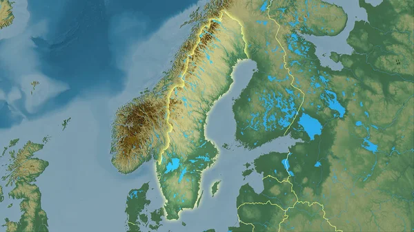
Sweden Area On The Topographic Relief Map In The Stereographic Projection - Raw Composition Of Raster Layers With Light Glowing Outline

Image, 5.03MB, 2880 × 1620 jpg
stock vector Imaginary cadastral map of an area with buildings and streets.

Imaginary Cadastral Map Of An Area With Buildings And Streets.

Vector, 0MB, 4000 × 3832 zip
stock image Professional cartographers working with cadastral map at table, closeup

Professional Cartographers Working With Cadastral Map At Table, Closeup

Image, 6.56MB, 5760 × 3840 jpg
stock image Land plot management - real estate concept with a vacant land and cadastral parcel available for building activity with cloudy sk

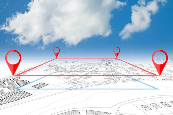
Land Plot Management - Real Estate Concept With A Vacant Land And Cadastral Parcel Available For Building Activity With Cloudy Sk

Image, 4.71MB, 4752 × 3168 jpg
stock vector Location pin marker with shifted outline isolated on white background

Location Pin Marker With Shifted Outline Isolated On White Background

Vector, 5.21MB, 5000 × 5000 eps
stock vector Location pin with colors of Germany flag. Map marker on transparent background. Vector icon for mobile apps, UI and web design. EPS10

Location Pin With Colors Of Germany Flag. Map Marker On Transparent Background. Vector Icon For Mobile Apps, UI And Web Design. EPS10

Vector, 5.24MB, 3974 × 4950 eps
stock image City Building Cadastre Map On Laptop Screen

City Building Cadastre Map On Laptop Screen

Image, 7.64MB, 8192 × 4320 jpg
stock vector Location pin point icon is marking a place on folded paper map with brown background

Location Pin Point Icon Is Marking A Place On Folded Paper Map With Brown Background

Vector, 5.45MB, 5000 × 5001 eps
stock image Imaginary cadastral map of territory with buildings, roads, land parcel and free green land available for building construction - Concept image with an engineer drawing an imaginary city map.

Imaginary Cadastral Map Of Territory With Buildings, Roads, Land Parcel And Free Green Land Available For Building Construction - Concept Image With An Engineer Drawing An Imaginary City Map.

Image, 10.1MB, 4742 × 3161 jpg
stock vector Retro futuristic topographic map, relief contour posters set. Abstract line represents land elevation with minimalist art style design. Cartography terrain pattern. Modern monochrome brutalism print

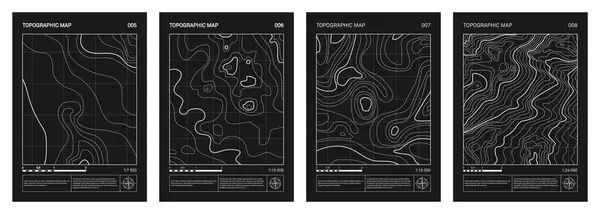
Retro Futuristic Topographic Map, Relief Contour Posters Set. Abstract Line Represents Land Elevation With Minimalist Art Style Design. Cartography Terrain Pattern. Modern Monochrome Brutalism Print

Vector, 7.89MB, 6054 × 2167 eps
Page 1 >> Next