
Stock image Disputed State
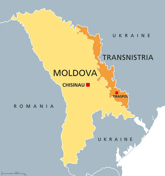
Moldova And Transnistria, Political Map. Republic Of Moldova, With Capital Chisinau, And The Pridnestrovian Moldavian Republic, PMR, A Disputed And Unrecognized Breakaway State, With Capital Tiraspol.
Vector, 2.65MB, 6000 × 6379 eps

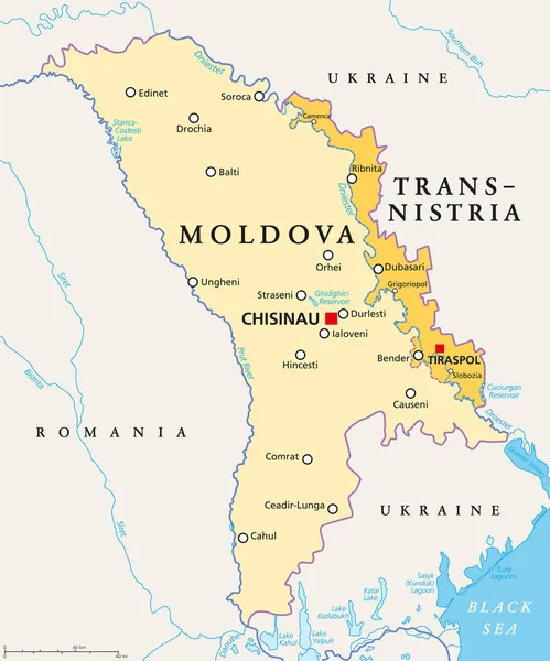
Moldova And Transnistria, Political Map. Republic Of Moldova, With Capital Chisinau, And The Pridnestrovian Moldavian Republic, PMR, A Disputed And Unrecognized Breakaway State, With Capital Tiraspol.
Vector, 3.04MB, 6000 × 7212 eps

Moldova And Transnistria, Gray Political Map. Republic Of Moldova, With Capital Chisinau, And Pridnestrovian Moldavian Republic, PMR, A Disputed And Unrecognized Breakaway State With Capital Tiraspol.
Vector, 2.74MB, 6000 × 6379 eps
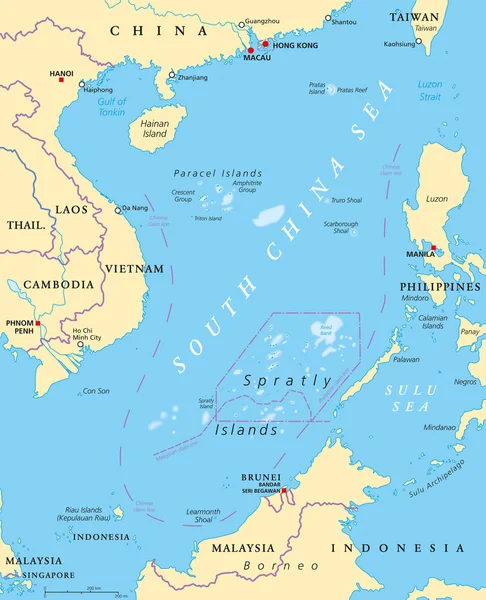
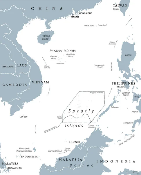
South China Sea Islands, Political Map. Islands, Atolls, Cays, Shoals, Reefs And Sandbars. Partially Claimed By China And Other Neighboring States. Paracel And Spratly Islands. Illustration. Vector.
Vector, 6.6MB, 7165 × 8833 eps
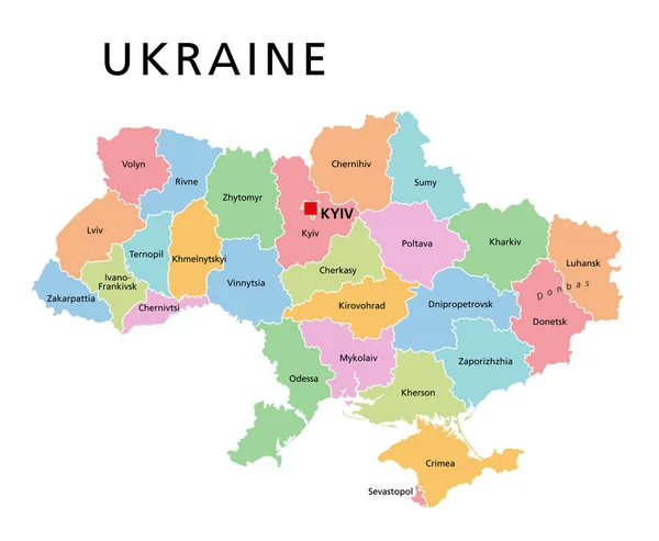
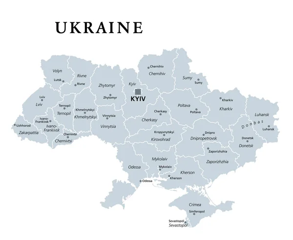
Ukraine, Colored Country Subdivision, Political Map. Administrative Divisions Of Ukraine, With Administrative Centers, A Unitary State In Eastern Europe With Capital Kyiv (Kiev). Illustration. Vector.
Vector, 2.95MB, 7298 × 6000 eps
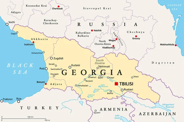
Georgia, Political Map, With Capital Tbilisi, And International Borders. Republic And Transcontinental Country In Eurasia, Located South Of The North Caucasus Federal District Of Russia. Illustration.
Vector, 2.96MB, 9000 × 6000 eps

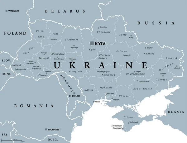
Ukraine, Administrative Divisions, Gray Political Map. Country And Unitary State In Eastern Europe, With Capital Kyiv (Kiev). Country Subdivision, With Administrative Centers. Illustration Over White.
Vector, 3.25MB, 7829 × 6000 eps
Ukraine, Country Subdivision, Gray Political Map. Administrative Divisions Of The Ukraine With Administrative Centers, A Unitary State In Eastern Europe With Capital Kyiv (Kiev). Illustration. Vector.
Vector, 2.99MB, 7298 × 6000 eps

Election Theft Text Message On Textured Grunge Copper And Vintage Gold Background
Image, 25.38MB, 6812 × 4541 jpg


Flags Of Japan And USA Waving With Cloudy Blue Sky Background, 3D Redering United States Of America, Chinese Communist Party CCP.
Image, 7.9MB, 5184 × 3456 jpg

Tokelau, Dependant Territory Of New Zealand, Gray Political Map. South Pacific Archipelago Consisting Of The Tropical Coral Atolls Atafu, Nukunonu And Fakaofo. Swains Island Is Territorial Disputed.
Vector, 2.42MB, 6000 × 6000 eps

Serbia And Kosovo, Landlocked Countries In Southeast Europe, Gray Political Map. Republic Of Serbia, With Capital Belgrade, And Republic Of Kosovo, Partially Recognized Country, With Capital Pristina.
Vector, 2.85MB, 6000 × 7843 eps
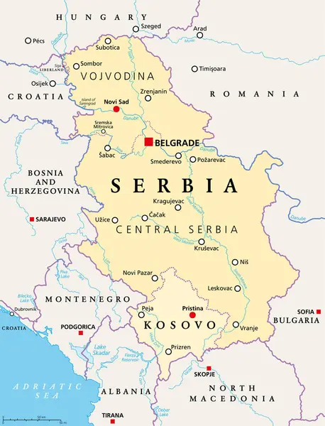
Serbia And Kosovo, Landlocked Countries In Southeast Europe, Political Map. The Republic Of Serbia, With Capital Belgrade, And Republic Of Kosovo, Partially Recognized Country, With Capital Pristina.
Vector, 3.6MB, 6000 × 7843 eps


Page 1 >> Next