Home
Images
Vectors
Videos
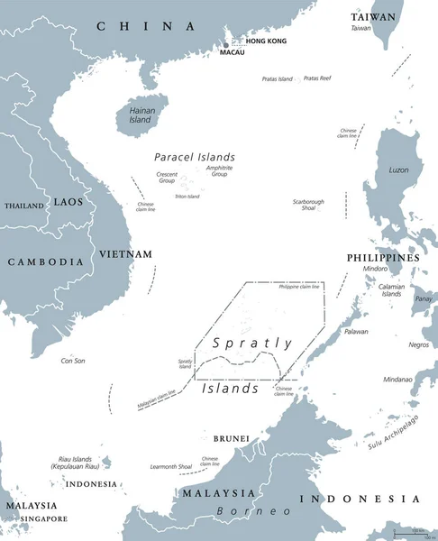
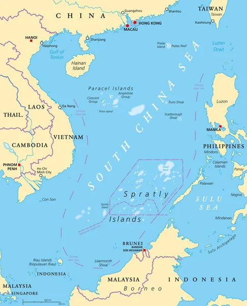
Stock vector South China Sea Islands, political map. Islands, atolls, cays, shoals, reefs and sandbars. Partially claimed by China and other neighboring states. Paracel and Spratly Islands. Illustration. Vector.
Published:
Jun.15, 2018 08:21:43
Author:
Furian
Views:
274
Downloads:
6
File type:
vector
/
eps
File size:
6.6 MB
Orginal size:
7165
x
8833
px
Available sizes:
S
(406 x 500)
M
(811 x 1000)
L
(1622 x 2000)
XL
(7165 x 8833)
VECT
(7165 x 8833)
EL0
(7165 x 8833)
Level:
silver
Download Vector
Vector topics:
Vector
Sea
Border
China
South
Country
Map
Cartography
Geography
Asia
Vietnam
Conflict
State
Island
Political
Reef
Islands
English
Malaysia
Atlas
Taiwan
Atoll
Indonesia
Shoal
Mapping
Scarborough
BRUNEI
Philippines
Cay
Archipelago
Sandbar
Disputed
South China Sea
Claimed
Political Map
Paracel
Paracel Islands
Pratas
Spratly
Spratly Island
English Labeling
Spratly Islands
Scarborough Shoal
Pratas Island
Similar stock vectors
South China Sea Islands Political Map
7209 × 8888
Hong Kong And Vicinity Political Map
7991 × 6000
Southeast Asia, Political Map With Capitals And Borders. Subregion Of Asia With Countries South Of China, East Of India, West Of New Guinea, North Of Australia. English Labeling. Illustration. Vector.
7292 × 8333
Vietnam - Blue Map With Neighboring Countries And Names. Vector Illustration
4910 × 6592
Position Map Of The Mariana Trench In Oceania
3100 × 2957
Asia Map In Vintage Style
4383 × 3700
The Vietnam Vector Map
3100 × 5582
Hong Kong Administrative Map
4212 × 3355