photo free
Home Images Vectors Videos

Stock image Division Of Territory

stock vector Modern City Map - Milwaukee Wisconsin city of the USA with neighborhoods and titles outline map

Modern City Map - Milwaukee Wisconsin City Of The USA With Neighborhoods And Titles Outline Map

Vector, 13.76MB, 5000 × 7976 eps
stock image Master of Your Domain words in 3d letters

Master Of Your Domain Words In 3d Letters

Image, 3.67MB, 4222 × 3574 jpg
stock vector Massachusetts - Connecticut - Rhode Island Map labelled black

Massachusetts - Connecticut - Rhode Island Map Labelled Black

Vector, 2.4MB, 7558 × 5000 eps
stock vector Modern City Map - Louisville Kentucky city of the USA with neighborhoods and titles outline map

Modern City Map - Louisville Kentucky City Of The USA With Neighborhoods And Titles Outline Map

Vector, 9.82MB, 6529 × 5000 eps
stock image Desaturated shape of Israel with its capital, main regional division and the separated Golan area. Labels. Topographic relief map. 3D rendering

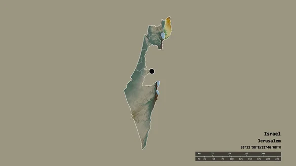
Desaturated Shape Of Israel With Its Capital, Main Regional Division And The Separated Golan Area. Labels. Topographic Relief Map. 3D Rendering

Image, 0.4MB, 2880 × 1620 jpg
stock vector Modern City Map - Tampa Florida city of the USA with neighborhoods and titles outline map

Modern City Map - Tampa Florida City Of The USA With Neighborhoods And Titles Outline Map

Vector, 10.26MB, 5000 × 5837 eps
stock vector Politician eats the planet

Politician Eats The Planet

Vector, 2.65MB, 6000 × 4000 eps
stock image Zoom in on Bruxelles (capital region of Belgium) extruded. Oblique perspective. Satellite imagery. 3D rendering

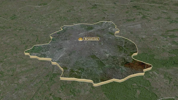
Zoom In On Bruxelles (capital Region Of Belgium) Extruded. Oblique Perspective. Satellite Imagery. 3D Rendering

Image, 3.54MB, 3840 × 2160 jpg
stock image Pennsylvania, state of United States. Colored shader data with lakes and rivers. Shape presented against its country area with informative overlays. 3D rendering

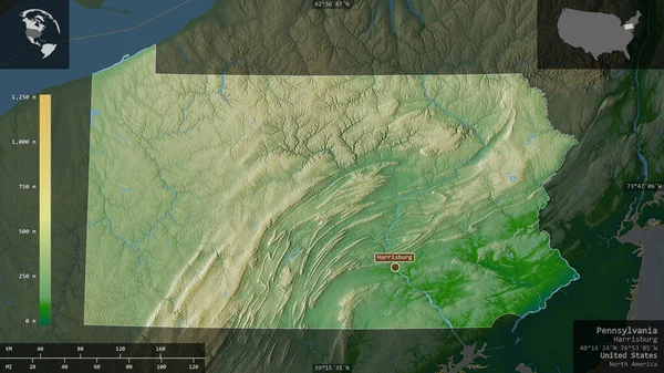
Pennsylvania, State Of United States. Colored Shader Data With Lakes And Rivers. Shape Presented Against Its Country Area With Informative Overlays. 3D Rendering

Image, 5.34MB, 2880 × 1620 jpg
stock vector Maldives map with Coronavirus warning illustration

Maldives Map With Coronavirus Warning Illustration

Vector, 7.11MB, 4541 × 6500 eps
stock image Mazandaran, province of Iran. Colored relief with lakes and rivers. Shape presented against its country area with informative overlays. 3D rendering

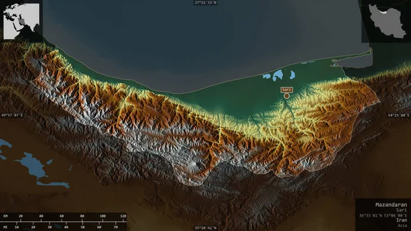
Mazandaran, Province Of Iran. Colored Relief With Lakes And Rivers. Shape Presented Against Its Country Area With Informative Overlays. 3D Rendering

Image, 3.6MB, 2880 × 1620 jpg
stock image Jablanicki , district of Serbia. Satellite imagery. Shape presented against its country area with informative overlays. 3D rendering

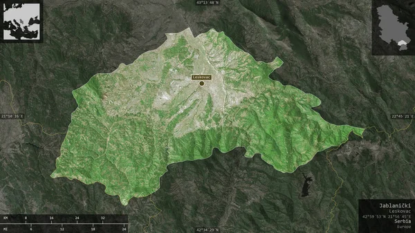
Jablanicki , District Of Serbia. Satellite Imagery. Shape Presented Against Its Country Area With Informative Overlays. 3D Rendering

Image, 6.26MB, 2880 × 1620 jpg
stock vector Portland Oregon city map USA labelled black illustration

Portland Oregon City Map USA Labelled Black Illustration

Vector, 9.04MB, 5849 × 5000 eps
stock image Gorno-Badakhshan, region of Tajikistan. Colored relief with lakes and rivers. Shape presented against its country area with informative overlays. 3D rendering

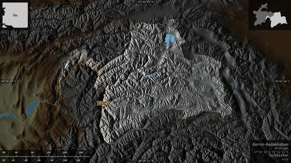
Gorno-Badakhshan, Region Of Tajikistan. Colored Relief With Lakes And Rivers. Shape Presented Against Its Country Area With Informative Overlays. 3D Rendering

Image, 5.27MB, 2880 × 1620 jpg
stock vector Modern City Map - Baltimore Maryland city of the USA with neighborhoods and titles outline map

Modern City Map - Baltimore Maryland City Of The USA With Neighborhoods And Titles Outline Map

Vector, 9.7MB, 5000 × 5829 eps
stock vector Washington DC USA federal state map with Coronavirus warning illustration

Washington DC USA Federal State Map With Coronavirus Warning Illustration

Vector, 7.74MB, 4500 × 5056 eps
stock image Shape of Valparaiso, region of Chile, with its capital isolated on white background. Satellite imagery. 3D rendering

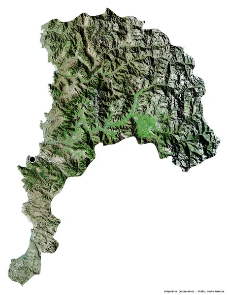
Shape Of Valparaiso, Region Of Chile, With Its Capital Isolated On White Background. Satellite Imagery. 3D Rendering

Image, 8.19MB, 2965 × 3836 jpg
stock vector Chile regions Map grey

Chile Regions Map Grey

Vector, 4.61MB, 3000 × 12673 eps
stock image Florida, state of United States. Satellite imagery. Shape presented against its country area with informative overlays. 3D rendering

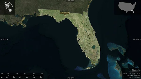
Florida, State Of United States. Satellite Imagery. Shape Presented Against Its Country Area With Informative Overlays. 3D Rendering

Image, 2.96MB, 2880 × 1620 jpg
stock vector Modern City Map - Neuss city of Germany with boroughs and titles DE outline map

Modern City Map - Neuss City Of Germany With Boroughs And Titles DE Outline Map

Vector, 7.84MB, 5000 × 5023 eps
stock image Area of California, state of Mainland United States, isolated on a solid background in a georeferenced bounding box. Labels. Satellite imagery. 3D rendering

Area Of California, State Of Mainland United States, Isolated On A Solid Background In A Georeferenced Bounding Box. Labels. Satellite Imagery. 3D Rendering

Image, 1.21MB, 2880 × 1620 jpg
stock vector Modern Map - San Francisco city of the USA

Modern Map - San Francisco City Of The USA

Vector, 11.58MB, 6118 × 5000 eps
stock image Shape of HaZafon, district of Israel, with its capital isolated on a solid color background. Topographic relief map. 3D rendering

Shape Of HaZafon, District Of Israel, With Its Capital Isolated On A Solid Color Background. Topographic Relief Map. 3D Rendering

Image, 4.72MB, 2461 × 3836 jpg
stock image Transcarpathia, region of Ukraine. Satellite imagery. Shape presented against its country area with informative overlays. 3D rendering

Transcarpathia, Region Of Ukraine. Satellite Imagery. Shape Presented Against Its Country Area With Informative Overlays. 3D Rendering

Image, 5.91MB, 2880 × 1620 jpg
stock vector Modern City Map - Washington DC city of the USA with neighborhoods and titles outline map

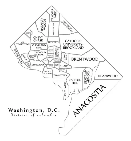
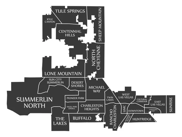
Modern City Map - Washington DC City Of The USA With Neighborhoods And Titles Outline Map

Vector, 8.67MB, 5000 × 5382 eps
stock image Zoom in on Chelyabinsk (region of Russia) extruded. Oblique perspective. Satellite imagery. 3D rendering

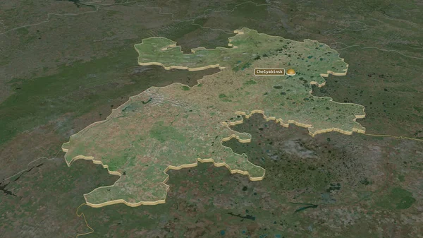
Zoom In On Chelyabinsk (region Of Russia) Extruded. Oblique Perspective. Satellite Imagery. 3D Rendering

Image, 3.81MB, 3840 × 2160 jpg
stock image Shape of Vesturland, region of Iceland, with its capital isolated on a solid color background. Satellite imagery. 3D rendering

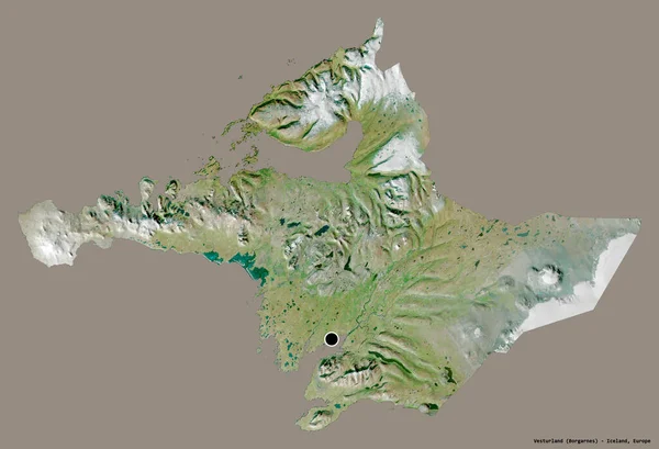
Shape Of Vesturland, Region Of Iceland, With Its Capital Isolated On A Solid Color Background. Satellite Imagery. 3D Rendering

Image, 5.19MB, 3836 × 2617 jpg
stock vector Modern City Map - Freiburg city of Germany with boroughs and tit

Modern City Map - Freiburg City Of Germany With Boroughs And Tit

Vector, 7.71MB, 5402 × 5000 eps
stock vector Modern City Map - Portland Oregon city of the USA with neighborhoods and titles outline map

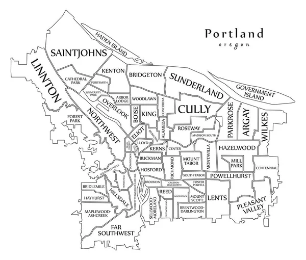
Modern City Map - Portland Oregon City Of The USA With Neighborhoods And Titles Outline Map

Vector, 9.48MB, 5882 × 5000 eps
stock vector Modern City Map - Philadelphia city of the USA with boroughs and

Modern City Map - Philadelphia City Of The USA With Boroughs And

Vector, 7.86MB, 5000 × 5402 eps
stock image Sikkim, state of India. Sentinel-2 satellite imagery. Shape isolated on solid background with informative overlays. Contains modified Copernicus Sentinel data

Sikkim, State Of India. Sentinel-2 Satellite Imagery. Shape Isolated On Solid Background With Informative Overlays. Contains Modified Copernicus Sentinel Data

Image, 5.82MB, 3144 × 3180 jpg
stock image Shape of HaZafon, district of Israel, with its capital isolated on solid background. Distance scale, region preview and labels. Topographic relief map. 3D rendering

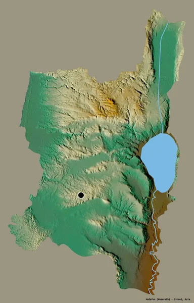
Shape Of HaZafon, District Of Israel, With Its Capital Isolated On Solid Background. Distance Scale, Region Preview And Labels. Topographic Relief Map. 3D Rendering

Image, 1.07MB, 2880 × 1620 jpg
stock vector Modern City Map - Fresno California city of the USA with neighborhoods and titles outline map

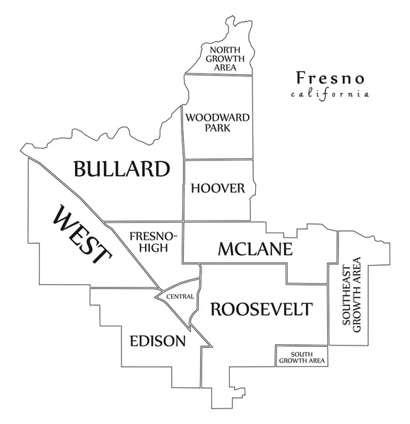
Modern City Map - Fresno California City Of The USA With Neighborhoods And Titles Outline Map

Vector, 7.53MB, 5000 × 5170 eps
stock image Residential area

Residential Area

Image, 11.28MB, 7039 × 2593 jpg
stock image Zoom in on Okinawa (prefecture of Japan) extruded. Oblique perspective. Satellite imagery. 3D rendering

Zoom In On Okinawa (prefecture Of Japan) Extruded. Oblique Perspective. Satellite Imagery. 3D Rendering

Image, 0.81MB, 3840 × 2160 jpg
stock image Salaj, county of Romania. Satellite imagery. Shape presented against its country area with informative overlays. 3D rendering

Salaj, County Of Romania. Satellite Imagery. Shape Presented Against Its Country Area With Informative Overlays. 3D Rendering

Image, 6.2MB, 2880 × 1620 jpg
stock vector Modern City Map - Charlotte North Carolina city of the USA with boroughs and titles outline map

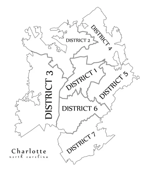
Modern City Map - Charlotte North Carolina City Of The USA With Boroughs And Titles Outline Map

Vector, 7.8MB, 5000 × 5784 eps
stock image Shape of Los Rios, region of Chile, with its capital isolated on white background. Satellite imagery. 3D rendering

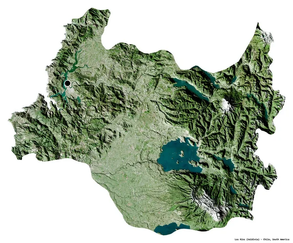
Shape Of Los Rios, Region Of Chile, With Its Capital Isolated On White Background. Satellite Imagery. 3D Rendering

Image, 12.52MB, 3836 × 3185 jpg
stock image Desaturated shape of Romania with its capital, main regional division and the separated Harghita area. Labels. Topographic relief map. 3D rendering

Desaturated Shape Of Romania With Its Capital, Main Regional Division And The Separated Harghita Area. Labels. Topographic Relief Map. 3D Rendering

Image, 1.74MB, 2880 × 1620 jpg
stock vector Las Vegas Nevada city map USA labelled black illustration

Las Vegas Nevada City Map USA Labelled Black Illustration

Vector, 7.99MB, 6641 × 5000 eps
stock image Hungary map, administrative division, old paper background blank

Hungary Map, Administrative Division, Old Paper Background Blank

Image, 1.31MB, 4804 × 3800 jpg
stock image Shape of Los Rios, region of Chile, with its capital isolated on a solid color background. Topographic relief map. 3D rendering

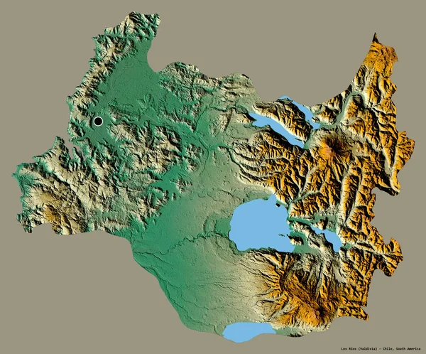
Shape Of Los Rios, Region Of Chile, With Its Capital Isolated On A Solid Color Background. Topographic Relief Map. 3D Rendering

Image, 10.79MB, 3836 × 3185 jpg
stock image Area of Nepal isolated on a solid background in a georeferenced bounding box. Main regional division, distance scale, labels. Topographic relief map. 3D rendering

Area Of Nepal Isolated On A Solid Background In A Georeferenced Bounding Box. Main Regional Division, Distance Scale, Labels. Topographic Relief Map. 3D Rendering

Image, 1.92MB, 3000 × 2000 jpg
stock image Area of La Libertad, region of Peru, isolated on a solid background in a georeferenced bounding box. Labels. Topographic relief map. 3D rendering

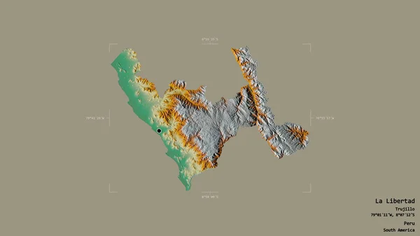
Area Of La Libertad, Region Of Peru, Isolated On A Solid Background In A Georeferenced Bounding Box. Labels. Topographic Relief Map. 3D Rendering

Image, 1.08MB, 2880 × 1620 jpg
stock image Tambov - region of Russia zoomed and highlighted. Satellite imagery. 3D rendering

Tambov - Region Of Russia Zoomed And Highlighted. Satellite Imagery. 3D Rendering

Image, 5.37MB, 2880 × 1620 jpg
stock image Broken egg with  European community

Broken Egg With European Community

Image, 4.55MB, 4736 × 3796 jpg
stock image Los Lagos, region of Chile. Satellite imagery. Shape presented against its country area with informative overlays. 3D rendering

Los Lagos, Region Of Chile. Satellite Imagery. Shape Presented Against Its Country Area With Informative Overlays. 3D Rendering

Image, 3.7MB, 2880 × 1620 jpg
stock image Shape of Region Metropolitana de Santiago, region of Chile, with its capital isolated on white background. Satellite imagery. 3D rendering

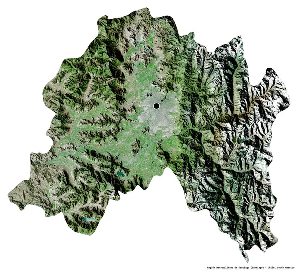
Shape Of Region Metropolitana De Santiago, Region Of Chile, With Its Capital Isolated On White Background. Satellite Imagery. 3D Rendering

Image, 12.7MB, 3836 × 3491 jpg
stock image Zoom in on Maule (region of Chile) extruded. Oblique perspective. Satellite imagery. 3D rendering

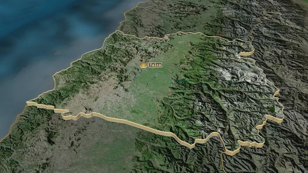
Zoom In On Maule (region Of Chile) Extruded. Oblique Perspective. Satellite Imagery. 3D Rendering

Image, 4.37MB, 3840 × 2160 jpg
stock image Idaho, state of United States. Colored shader data with lakes and rivers. Shape outlined against its country area. 3D rendering

Idaho, State Of United States. Colored Shader Data With Lakes And Rivers. Shape Outlined Against Its Country Area. 3D Rendering

Image, 6.82MB, 2880 × 1620 jpg
Page 1 >> Next