photo free
Home Images Vectors Videos

Stock image Geoscheme

stock vector Regions of Africa political map

Regions Of Africa Political Map

Vector, 4.37MB, 8133 × 7771 eps
stock vector Central Asia, or Middle Asia, colored political map. Region of Asia from Caspian Sea to western China, and from Russia to Afghanistan. Kazakhstan, Kyrgyzstan, Tajikistan, Turkmenistan, and Uzbekistan.

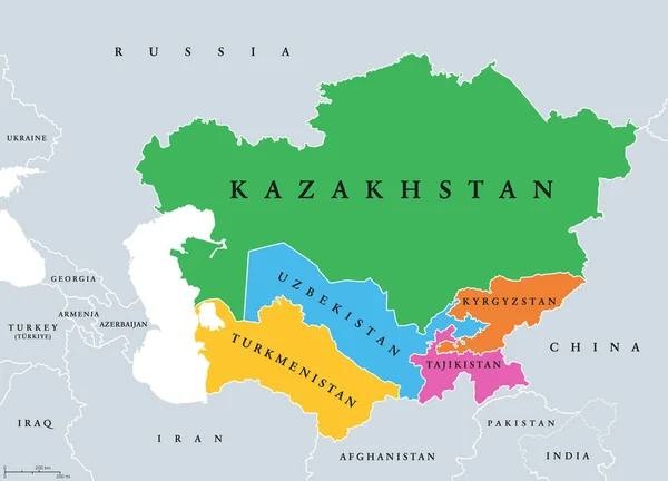
Central Asia, Or Middle Asia, Colored Political Map. Region Of Asia From Caspian Sea To Western China, And From Russia To Afghanistan. Kazakhstan, Kyrgyzstan, Tajikistan, Turkmenistan, And Uzbekistan.

Vector, 2.75MB, 8323 × 6000 eps
stock vector Subregions of Oceania, political map. Geoscheme with regions in the Pacific Ocean and next to Asia. Melanesia, Micronesia, Polynesia, and Australasia, short for Australia and New Zealand. Vector.

Subregions Of Oceania, Political Map. Geoscheme With Regions In The Pacific Ocean And Next To Asia. Melanesia, Micronesia, Polynesia, And Australasia, Short For Australia And New Zealand. Vector.

Vector, 5.06MB, 9000 × 6000 eps
stock vector Main regions of Asia. Political map with single countries. Colored subregions of the Asian continent. Central, East, North, South, Southeast and Western Asia. English labeled. Illustration. Vector.

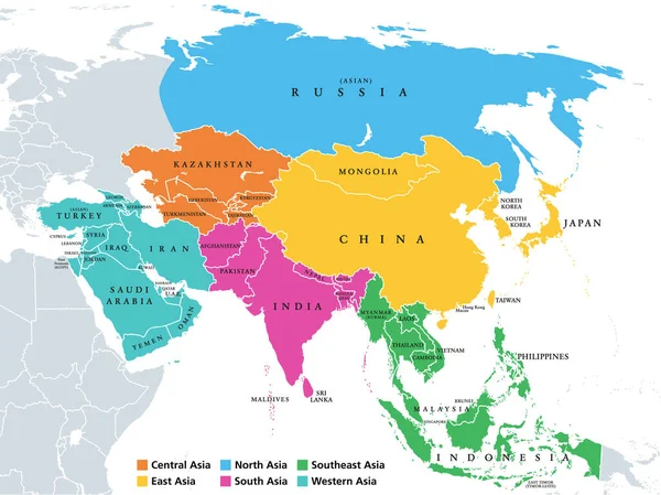
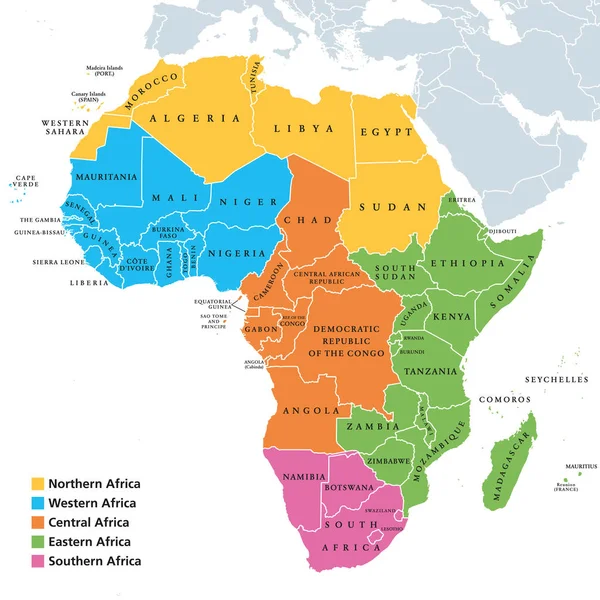
Main Regions Of Asia. Political Map With Single Countries. Colored Subregions Of The Asian Continent. Central, East, North, South, Southeast And Western Asia. English Labeled. Illustration. Vector.

Vector, 3.7MB, 8015 × 6000 eps
stock vector Western Asia, geoscheme and political map. Subregion of Asia, used for statistical purposes, covering geographical regions spanning from Anatolia, Caucasus, Levant, Mesopotamia till Arabian Peninsula.

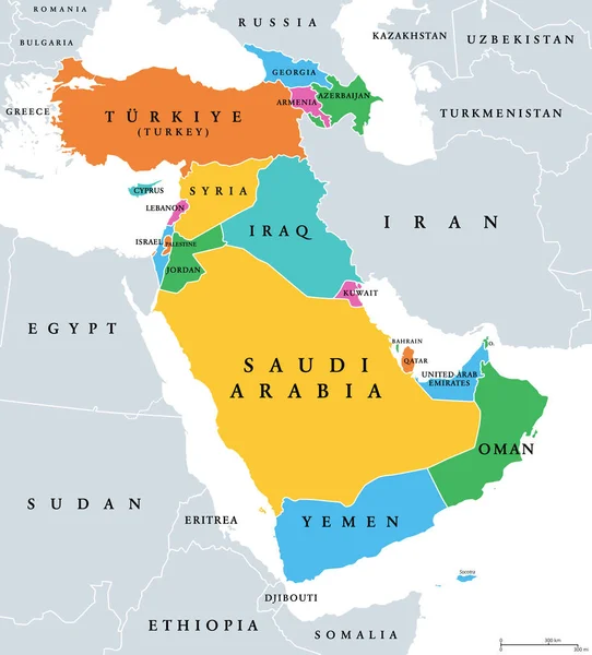
Western Asia, Geoscheme And Political Map. Subregion Of Asia, Used For Statistical Purposes, Covering Geographical Regions Spanning From Anatolia, Caucasus, Levant, Mesopotamia Till Arabian Peninsula.

Vector, 2.94MB, 6000 × 6632 eps
stock vector The Americas, geoscheme and political map. The North American subregion with intermediate regions Caribbean, Northern and Central America, and the subregion South America. Subdivisions for statistics.

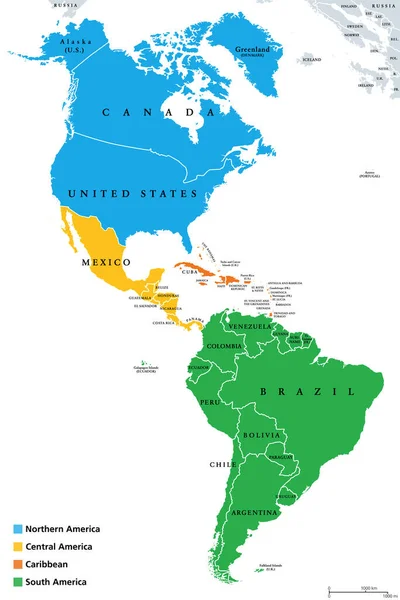
The Americas, Geoscheme And Political Map. The North American Subregion With Intermediate Regions Caribbean, Northern And Central America, And The Subregion South America. Subdivisions For Statistics.

Vector, 3.3MB, 6000 × 8997 eps
stock vector Central Asia, gray political map. Subregion of Asia, consisting of former Soviet republics, stretching from the Caspian Sea to China and Mongolia, and from south of Russia to Afghanistan and Iran.

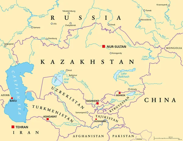
Central Asia, Gray Political Map. Subregion Of Asia, Consisting Of Former Soviet Republics, Stretching From The Caspian Sea To China And Mongolia, And From South Of Russia To Afghanistan And Iran.

Vector, 2.64MB, 8186 × 6000 eps
stock vector Central Asia, political map with capitals. Subregion of Asia, consisting of former Soviet republics stretching from Caspian Sea to China and Mongolia, and from Afghanistan and Iran to south of Russia.

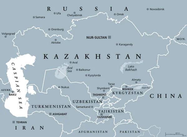
Central Asia, Political Map With Capitals. Subregion Of Asia, Consisting Of Former Soviet Republics Stretching From Caspian Sea To China And Mongolia, And From Afghanistan And Iran To South Of Russia.

Vector, 3.68MB, 7800 × 6000 eps
stock vector Africa regions map with single countries

Africa Regions Map With Single Countries

Vector, 5.25MB, 8033 × 8033 eps
Page 1 >> Next