
Stock image Gnb page 2

Ilha De Bolama In The North Atlantic Ocean On A Topographic, OSM Humanitarian Style Map
Image, 1.7MB, 2880 × 1620 jpg

Ilha De Elia In The North Atlantic Ocean On A Satellite Image Taken In March 4, 2024
Image, 5.78MB, 2880 × 1620 jpg

Ilha Enu In The North Atlantic Ocean, Belonging To Guinea-Bissau, Isolated On A Topographic, OSM Humanitarian Style Map, With Distance Scale
Image, 0.66MB, 2160 × 2160 jpg

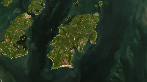
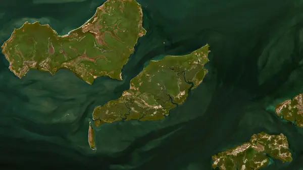
Ilha De Uno In The North Atlantic Ocean On A Satellite Image Taken In May 13, 2024
Image, 5.28MB, 2880 × 1620 jpg

Ilha Das Galinhas In The North Atlantic Ocean, Belonging To Guinea-Bissau, Isolated On A Topographic, OSM Humanitarian Style Map, With Distance Scale
Image, 0.58MB, 2160 × 2160 jpg
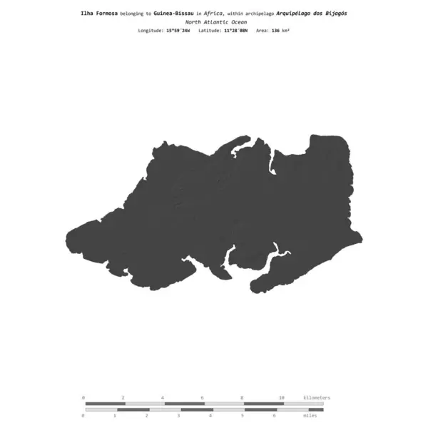
Ilha Formosa In The North Atlantic Ocean, Belonging To Guinea-Bissau, Isolated On A Bilevel Elevation Map, With Distance Scale
Image, 0.36MB, 2160 × 2160 jpg

Ilha Roxa In The North Atlantic Ocean, Belonging To Guinea-Bissau, Isolated On A Bilevel Elevation Map, With Distance Scale
Image, 0.36MB, 2160 × 2160 jpg

Guinea Bissau Flag Depicted On Side Wall Of White Delivery Van Close Up. Shipping And Local Delivery Concept
Image, 1.91MB, 4928 × 3264 jpg

Guinea Bissau Flag Depicted On Folded Wavy Fabric Of Old Cloth Close Up
Image, 7.82MB, 4928 × 3264 jpg

Ilha De Pecixe In The North Atlantic Ocean On A Colored Elevation Map
Image, 1.12MB, 2880 × 1620 jpg

GuineaBissau Map Vintage Stamp Retro Style Handmade Label GuineaBissau Badge Or Element For
Vector, 12.12MB, 8333 × 8333 eps

Guinea Bissau Flag Depicted On Side Wall Of White Delivery Van Close Up. Shipping And Local Delivery Concept
Image, 2.36MB, 4928 × 3264 jpg

Guinea Bissau Flag And Big Stack Of Shipping Cargo Containers In Docks With Sky Background Close Up
Image, 4.81MB, 4928 × 3264 jpg

Ilha De Pecixe In The North Atlantic Ocean, Belonging To Guinea-Bissau, Isolated On A Topographic, OSM Humanitarian Style Map, With Distance Scale
Image, 0.82MB, 2160 × 2160 jpg

Ilha Bubaque In The North Atlantic Ocean, Belonging To Guinea-Bissau, Isolated On A Topographic, OSM Humanitarian Style Map, With Distance Scale
Image, 0.79MB, 2160 × 2160 jpg
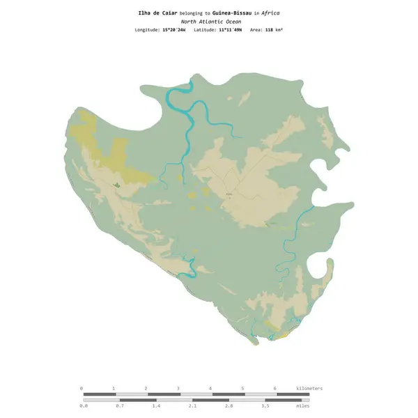
Ilha De Caiar In The North Atlantic Ocean, Belonging To Guinea-Bissau, Isolated On A Topographic, OSM Humanitarian Style Map, With Distance Scale
Image, 1.03MB, 2160 × 2160 jpg


Ilha De Caiar In The North Atlantic Ocean, Belonging To Guinea-Bissau, Isolated On A Satellite Image Taken In January 4, 2024, With Distance Scale
Image, 1.99MB, 2160 × 2160 jpg

Ilha Enu In The North Atlantic Ocean, Belonging To Guinea-Bissau, Isolated On A Satellite Image Taken In April 14, 2023, With Distance Scale
Image, 1.31MB, 2160 × 2160 jpg

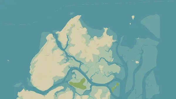
Ilha De Jeta In The North Atlantic Ocean, Belonging To Guinea-Bissau, Isolated On A Satellite Image Taken In November 25, 2023, With Distance Scale
Image, 1.39MB, 2160 × 2160 jpg

Ilha De Elia In The North Atlantic Ocean - Belonging To Guinea-Bissau. Described Location Diagram With Yellow Shape Of The Island And Sample Maps Of Its Surroundings
Image, 2.4MB, 3840 × 2160 jpg

Ilha Enu In The North Atlantic Ocean - Belonging To Guinea-Bissau. Described Location Diagram With Yellow Shape Of The Island And Sample Maps Of Its Surroundings
Image, 2.23MB, 3840 × 2160 jpg

Ilha De Bolama In The North Atlantic Ocean - Belonging To Guinea-Bissau. Described Location Diagram With Yellow Shape Of The Island And Sample Maps Of Its Surroundings
Image, 2.24MB, 3840 × 2160 jpg
Ilha Roxa In The North Atlantic Ocean On A Satellite Image Taken In April 4, 2023
Image, 4.53MB, 2880 × 1620 jpg


Ilha Formosa In The North Atlantic Ocean - Belonging To Guinea-Bissau. Described Location Diagram With Yellow Shape Of The Island And Sample Maps Of Its Surroundings
Image, 2.37MB, 3840 × 2160 jpg

Ilha De Pecixe In The North Atlantic Ocean - Belonging To Guinea-Bissau. Described Location Diagram With Yellow Shape Of The Island And Sample Maps Of Its Surroundings
Image, 2.5MB, 3840 × 2160 jpg

Ilha De Orangozinho In The North Atlantic Ocean, Belonging To Guinea-Bissau, Isolated On A Satellite Image Taken In January 19, 2023, With Distance Scale
Image, 1.49MB, 2160 × 2160 jpg

Ilha Maio In The North Atlantic Ocean, Belonging To Guinea-Bissau, Isolated On A Satellite Image Taken In December 30, 2023, With Distance Scale
Image, 1.76MB, 2160 × 2160 jpg

Ilha Carache In The North Atlantic Ocean On A Topographic, OSM Humanitarian Style Map
Image, 0.86MB, 2880 × 1620 jpg

Ilha De Orangozinho In The North Atlantic Ocean On A Topographic, OSM Humanitarian Style Map
Image, 1.93MB, 2880 × 1620 jpg

Ilha De Bolama In The North Atlantic Ocean On A Satellite Image Taken In May 8, 2024
Image, 5.77MB, 2880 × 1620 jpg

Ilha De Como In The North Atlantic Ocean On A Satellite Image Taken In April 3, 2024
Image, 6.61MB, 2880 × 1620 jpg

Ilha Formosa In The North Atlantic Ocean On A Satellite Image Taken In April 9, 2023
Image, 4.84MB, 2880 × 1620 jpg


Guinea-Bissau Round Sign. Futuristic Satelite View Of The World Centered To Guinea-Bissau. Country Badge With Map, Round Text And Binary Background. Radiant Vector Illustration.
Vector, 5.17MB, 5488 × 5488 eps
Guinea-Bissau Heart Flag Logo. Country Name Text Around Guinea-Bissau Flag In A Shape Of Heart. Classy Vector Illustration.
Vector, 11.93MB, 5477 × 5477 eps

Guinea Bissau Flag Depicted On Folded Wavy Fabric Of Old Cloth Close Up
Image, 8.12MB, 4928 × 3264 jpg
Ilha Maio In The North Atlantic Ocean On A Topographic, OSM Humanitarian Style Map
Image, 1.51MB, 2880 × 1620 jpg
Ilha Carache In The North Atlantic Ocean On A Satellite Image Taken In May 8, 2024
Image, 4.95MB, 2880 × 1620 jpg

Ilha Das Galinhas In The North Atlantic Ocean On A Satellite Image Taken In January 19, 2023
Image, 3.87MB, 2880 × 1620 jpg

Ilha De Elia In The North Atlantic Ocean, Belonging To Guinea-Bissau, Isolated On A Topographic, OSM Humanitarian Style Map, With Distance Scale
Image, 0.76MB, 2160 × 2160 jpg

Ilha De Imbone In The North Atlantic Ocean, Belonging To Guinea-Bissau, Isolated On A Topographic, OSM Humanitarian Style Map, With Distance Scale
Image, 0.53MB, 2160 × 2160 jpg

Ilha De Uno In The North Atlantic Ocean - Belonging To Guinea-Bissau. Described Location Diagram With Yellow Shape Of The Island And Sample Maps Of Its Surroundings
Image, 2.04MB, 3840 × 2160 jpg

Ilha Maio In The North Atlantic Ocean, Belonging To Guinea-Bissau, Isolated On A Bilevel Elevation Map, With Distance Scale
Image, 0.36MB, 2160 × 2160 jpg


Ilha Roxa In The North Atlantic Ocean, Belonging To Guinea-Bissau, Isolated On A Satellite Image Taken In December 30, 2023, With Distance Scale
Image, 1.89MB, 2160 × 2160 jpg

Ilha Das Galinhas In The North Atlantic Ocean On A Topographic, OSM Humanitarian Style Map
Image, 0.68MB, 2880 × 1620 jpg


Ilha Carache In The North Atlantic Ocean, Belonging To Guinea-Bissau, Isolated On A Topographic, OSM Humanitarian Style Map, With Distance Scale
Image, 0.67MB, 2160 × 2160 jpg
Previous << Page 2 >> Next