photo free
Home Images Vectors Videos

Stock image Gnb

stock image Guinea Bissau flag and big stack of shipping cargo containers in docks with sky background close up

Guinea Bissau Flag And Big Stack Of Shipping Cargo Containers In Docks With Sky Background Close Up

Image, 4.9MB, 4928 × 3264 jpg
stock image Guinea Bissau flag depicted on folded wavy fabric of old cloth close up

Guinea Bissau Flag Depicted On Folded Wavy Fabric Of Old Cloth Close Up

Image, 7.34MB, 4928 × 3264 jpg
stock image Ilha Enu in the North Atlantic Ocean on a colored elevation map

Ilha Enu In The North Atlantic Ocean On A Colored Elevation Map

Image, 0.67MB, 2880 × 1620 jpg
stock image Ilha Formosa in the North Atlantic Ocean on a topographic, OSM Humanitarian style map

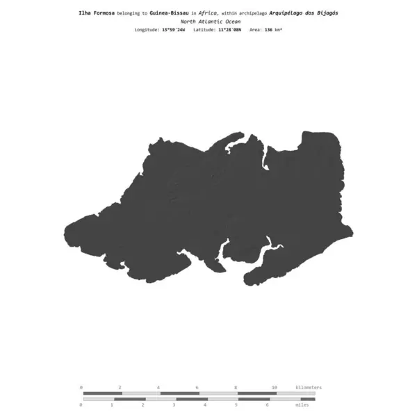
Ilha Formosa In The North Atlantic Ocean On A Topographic, OSM Humanitarian Style Map

Image, 1.38MB, 2880 × 1620 jpg
stock image Ilha de Imbone in the North Atlantic Ocean - belonging to Guinea-Bissau. Described location diagram with yellow shape of the island and sample maps of its surroundings

Ilha De Imbone In The North Atlantic Ocean - Belonging To Guinea-Bissau. Described Location Diagram With Yellow Shape Of The Island And Sample Maps Of Its Surroundings

Image, 2.48MB, 3840 × 2160 jpg
stock image Ilha Maio in the North Atlantic Ocean on a satellite image taken in April 24, 2023

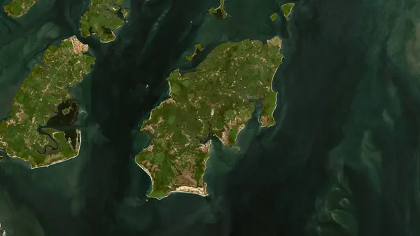
Ilha Maio In The North Atlantic Ocean On A Satellite Image Taken In April 24, 2023

Image, 4.71MB, 2880 × 1620 jpg
stock image Ilha de Imbone in the North Atlantic Ocean, belonging to Guinea-Bissau, isolated on a bilevel elevation map, with distance scale

Ilha De Imbone In The North Atlantic Ocean, Belonging To Guinea-Bissau, Isolated On A Bilevel Elevation Map, With Distance Scale

Image, 0.28MB, 2160 × 2160 jpg
stock image Ilha Caravela in the North Atlantic Ocean - belonging to Guinea-Bissau. Described location diagram with yellow shape of the island and sample maps of its surroundings

Ilha Caravela In The North Atlantic Ocean - Belonging To Guinea-Bissau. Described Location Diagram With Yellow Shape Of The Island And Sample Maps Of Its Surroundings

Image, 1.98MB, 3840 × 2160 jpg
stock image Ilha Carache in the North Atlantic Ocean - belonging to Guinea-Bissau. Described location diagram with yellow shape of the island and sample maps of its surroundings

Ilha Carache In The North Atlantic Ocean - Belonging To Guinea-Bissau. Described Location Diagram With Yellow Shape Of The Island And Sample Maps Of Its Surroundings

Image, 2.2MB, 3840 × 2160 jpg
stock image Ilha de Como in the North Atlantic Ocean, belonging to Guinea-Bissau, isolated on a satellite image taken in October 31, 2023, with distance scale

Ilha De Como In The North Atlantic Ocean, Belonging To Guinea-Bissau, Isolated On A Satellite Image Taken In October 31, 2023, With Distance Scale

Image, 1.61MB, 2160 × 2160 jpg
stock vector Patriotic GNB Logo with Star and American Flag Straps. Letter GNB Logo with USA Flag

Patriotic GNB Logo With Star And American Flag Straps. Letter GNB Logo With USA Flag

Vector, 5.72MB, 5557 × 5556 eps
stock image Ilha de Uno in the North Atlantic Ocean, belonging to Guinea-Bissau, isolated on a satellite image taken in October 26, 2022, with distance scale

Ilha De Uno In The North Atlantic Ocean, Belonging To Guinea-Bissau, Isolated On A Satellite Image Taken In October 26, 2022, With Distance Scale

Image, 1.41MB, 2160 × 2160 jpg
stock image Ilha Maio in the North Atlantic Ocean - belonging to Guinea-Bissau. Described location diagram with yellow shape of the island and sample maps of its surroundings

Ilha Maio In The North Atlantic Ocean - Belonging To Guinea-Bissau. Described Location Diagram With Yellow Shape Of The Island And Sample Maps Of Its Surroundings

Image, 2.33MB, 3840 × 2160 jpg
stock image Ilha Bubaque in the North Atlantic Ocean, belonging to Guinea-Bissau, isolated on a satellite image taken in February 3, 2024, with distance scale

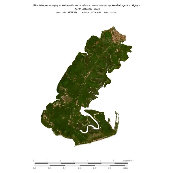
Ilha Bubaque In The North Atlantic Ocean, Belonging To Guinea-Bissau, Isolated On A Satellite Image Taken In February 3, 2024, With Distance Scale

Image, 1.43MB, 2160 × 2160 jpg
stock image Ilha Carache in the North Atlantic Ocean, belonging to Guinea-Bissau, isolated on a satellite image taken in December 30, 2023, with distance scale

Ilha Carache In The North Atlantic Ocean, Belonging To Guinea-Bissau, Isolated On A Satellite Image Taken In December 30, 2023, With Distance Scale

Image, 1.29MB, 2160 × 2160 jpg
stock image Ilha de Orangozinho in the North Atlantic Ocean, belonging to Guinea-Bissau, isolated on a bilevel elevation map, with distance scale

Ilha De Orangozinho In The North Atlantic Ocean, Belonging To Guinea-Bissau, Isolated On A Bilevel Elevation Map, With Distance Scale

Image, 0.37MB, 2160 × 2160 jpg
stock image Ilha Caravela in the North Atlantic Ocean, belonging to Guinea-Bissau, isolated on a bilevel elevation map, with distance scale

Ilha Caravela In The North Atlantic Ocean, Belonging To Guinea-Bissau, Isolated On A Bilevel Elevation Map, With Distance Scale

Image, 0.35MB, 2160 × 2160 jpg
stock image Ilha Bubaque in the North Atlantic Ocean on a topographic, OSM Humanitarian style map

Ilha Bubaque In The North Atlantic Ocean On A Topographic, OSM Humanitarian Style Map

Image, 1.64MB, 2880 × 1620 jpg
stock image Ilha de Orangozinho in the North Atlantic Ocean on a satellite image taken in January 14, 2024

Ilha De Orangozinho In The North Atlantic Ocean On A Satellite Image Taken In January 14, 2024

Image, 4.87MB, 2880 × 1620 jpg
stock vector GNB letter logo design for technology company. GNB logo design black and white color combination. GNB logo, GNB vector, GNB design, GNB icon, GNB alphabet. GNB typography logo design.

GNB Letter Logo Design For Technology Company. GNB Logo Design Black And White Color Combination. GNB Logo, GNB Vector, GNB Design, GNB Icon, GNB Alphabet. GNB Typography Logo Design.

Vector, 5.11MB, 9792 × 9793 eps
stock image Guinea Bissau flag and big stack of shipping cargo containers in docks with sky background close up

Guinea Bissau Flag And Big Stack Of Shipping Cargo Containers In Docks With Sky Background Close Up

Image, 5.57MB, 4928 × 3264 jpg
stock image Ilha Formosa in the North Atlantic Ocean on a colored elevation map

Ilha Formosa In The North Atlantic Ocean On A Colored Elevation Map

Image, 0.95MB, 2880 × 1620 jpg
stock image Ilha Maio in the North Atlantic Ocean, belonging to Guinea-Bissau, isolated on a topographic, OSM Humanitarian style map, with distance scale

Ilha Maio In The North Atlantic Ocean, Belonging To Guinea-Bissau, Isolated On A Topographic, OSM Humanitarian Style Map, With Distance Scale

Image, 0.81MB, 2160 × 2160 jpg
stock image Ilha de Jeta in the North Atlantic Ocean on a topographic, OSM Humanitarian style map

Ilha De Jeta In The North Atlantic Ocean On A Topographic, OSM Humanitarian Style Map

Image, 1.43MB, 2880 × 1620 jpg
stock image Ilha Roxa in the North Atlantic Ocean on a colored elevation map

Ilha Roxa In The North Atlantic Ocean On A Colored Elevation Map

Image, 0.85MB, 2880 × 1620 jpg
stock image Ilha de Bolama in the North Atlantic Ocean on a topographic, OSM Humanitarian style map

Ilha De Bolama In The North Atlantic Ocean On A Topographic, OSM Humanitarian Style Map

Image, 1.7MB, 2880 × 1620 jpg
stock image Ilha de Elia in the North Atlantic Ocean on a satellite image taken in March 4, 2024

Ilha De Elia In The North Atlantic Ocean On A Satellite Image Taken In March 4, 2024

Image, 5.78MB, 2880 × 1620 jpg
stock image Ilha Enu in the North Atlantic Ocean, belonging to Guinea-Bissau, isolated on a topographic, OSM Humanitarian style map, with distance scale

Ilha Enu In The North Atlantic Ocean, Belonging To Guinea-Bissau, Isolated On A Topographic, OSM Humanitarian Style Map, With Distance Scale

Image, 0.66MB, 2160 × 2160 jpg
stock image Ilha de Uno in the North Atlantic Ocean on a satellite image taken in May 13, 2024

Ilha De Uno In The North Atlantic Ocean On A Satellite Image Taken In May 13, 2024

Image, 5.28MB, 2880 × 1620 jpg
stock image Ilha das Galinhas in the North Atlantic Ocean, belonging to Guinea-Bissau, isolated on a topographic, OSM Humanitarian style map, with distance scale

Ilha Das Galinhas In The North Atlantic Ocean, Belonging To Guinea-Bissau, Isolated On A Topographic, OSM Humanitarian Style Map, With Distance Scale

Image, 0.58MB, 2160 × 2160 jpg
stock image Ilha Formosa in the North Atlantic Ocean, belonging to Guinea-Bissau, isolated on a bilevel elevation map, with distance scale

Ilha Formosa In The North Atlantic Ocean, Belonging To Guinea-Bissau, Isolated On A Bilevel Elevation Map, With Distance Scale

Image, 0.36MB, 2160 × 2160 jpg
stock image Ilha Roxa in the North Atlantic Ocean, belonging to Guinea-Bissau, isolated on a bilevel elevation map, with distance scale

Ilha Roxa In The North Atlantic Ocean, Belonging To Guinea-Bissau, Isolated On A Bilevel Elevation Map, With Distance Scale

Image, 0.36MB, 2160 × 2160 jpg
stock image Guinea Bissau flag depicted on side wall of white delivery van close up. Shipping and local delivery concept

Guinea Bissau Flag Depicted On Side Wall Of White Delivery Van Close Up. Shipping And Local Delivery Concept

Image, 1.91MB, 4928 × 3264 jpg
stock image Guinea Bissau flag depicted on folded wavy fabric of old cloth close up

Guinea Bissau Flag Depicted On Folded Wavy Fabric Of Old Cloth Close Up

Image, 7.82MB, 4928 × 3264 jpg
stock image Ilha de Pecixe in the North Atlantic Ocean on a colored elevation map

Ilha De Pecixe In The North Atlantic Ocean On A Colored Elevation Map

Image, 1.12MB, 2880 × 1620 jpg
stock vector GuineaBissau map vintage stamp Retro style handmade label GuineaBissau badge or element for

GuineaBissau Map Vintage Stamp Retro Style Handmade Label GuineaBissau Badge Or Element For

Vector, 12.12MB, 8333 × 8333 eps
stock image Guinea Bissau flag depicted on side wall of white delivery van close up. Shipping and local delivery concept

Guinea Bissau Flag Depicted On Side Wall Of White Delivery Van Close Up. Shipping And Local Delivery Concept

Image, 2.36MB, 4928 × 3264 jpg
stock image Guinea Bissau flag and big stack of shipping cargo containers in docks with sky background close up

Guinea Bissau Flag And Big Stack Of Shipping Cargo Containers In Docks With Sky Background Close Up

Image, 4.81MB, 4928 × 3264 jpg
stock image Ilha de Pecixe in the North Atlantic Ocean, belonging to Guinea-Bissau, isolated on a topographic, OSM Humanitarian style map, with distance scale

Ilha De Pecixe In The North Atlantic Ocean, Belonging To Guinea-Bissau, Isolated On A Topographic, OSM Humanitarian Style Map, With Distance Scale

Image, 0.82MB, 2160 × 2160 jpg
stock image Ilha Bubaque in the North Atlantic Ocean, belonging to Guinea-Bissau, isolated on a topographic, OSM Humanitarian style map, with distance scale

Ilha Bubaque In The North Atlantic Ocean, Belonging To Guinea-Bissau, Isolated On A Topographic, OSM Humanitarian Style Map, With Distance Scale

Image, 0.79MB, 2160 × 2160 jpg
stock image Ilha de Caiar in the North Atlantic Ocean, belonging to Guinea-Bissau, isolated on a topographic, OSM Humanitarian style map, with distance scale

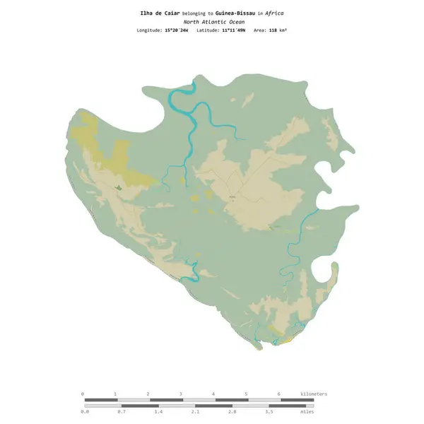
Ilha De Caiar In The North Atlantic Ocean, Belonging To Guinea-Bissau, Isolated On A Topographic, OSM Humanitarian Style Map, With Distance Scale

Image, 1.03MB, 2160 × 2160 jpg
stock image Ilha Maio in the North Atlantic Ocean on a colored elevation map

Ilha Maio In The North Atlantic Ocean On A Colored Elevation Map

Image, 0.79MB, 2880 × 1620 jpg
stock image Ilha de Caiar in the North Atlantic Ocean, belonging to Guinea-Bissau, isolated on a satellite image taken in January 4, 2024, with distance scale

Ilha De Caiar In The North Atlantic Ocean, Belonging To Guinea-Bissau, Isolated On A Satellite Image Taken In January 4, 2024, With Distance Scale

Image, 1.99MB, 2160 × 2160 jpg
stock image Ilha Enu in the North Atlantic Ocean, belonging to Guinea-Bissau, isolated on a satellite image taken in April 14, 2023, with distance scale

Ilha Enu In The North Atlantic Ocean, Belonging To Guinea-Bissau, Isolated On A Satellite Image Taken In April 14, 2023, With Distance Scale

Image, 1.31MB, 2160 × 2160 jpg
stock image Ilha de Jeta in the North Atlantic Ocean, belonging to Guinea-Bissau, isolated on a satellite image taken in November 25, 2023, with distance scale

Ilha De Jeta In The North Atlantic Ocean, Belonging To Guinea-Bissau, Isolated On A Satellite Image Taken In November 25, 2023, With Distance Scale

Image, 1.39MB, 2160 × 2160 jpg
stock image Ilha de Elia in the North Atlantic Ocean - belonging to Guinea-Bissau. Described location diagram with yellow shape of the island and sample maps of its surroundings

Ilha De Elia In The North Atlantic Ocean - Belonging To Guinea-Bissau. Described Location Diagram With Yellow Shape Of The Island And Sample Maps Of Its Surroundings

Image, 2.4MB, 3840 × 2160 jpg
stock image Ilha Enu in the North Atlantic Ocean - belonging to Guinea-Bissau. Described location diagram with yellow shape of the island and sample maps of its surroundings

Ilha Enu In The North Atlantic Ocean - Belonging To Guinea-Bissau. Described Location Diagram With Yellow Shape Of The Island And Sample Maps Of Its Surroundings

Image, 2.23MB, 3840 × 2160 jpg
stock image Ilha de Bolama in the North Atlantic Ocean - belonging to Guinea-Bissau. Described location diagram with yellow shape of the island and sample maps of its surroundings

Ilha De Bolama In The North Atlantic Ocean - Belonging To Guinea-Bissau. Described Location Diagram With Yellow Shape Of The Island And Sample Maps Of Its Surroundings

Image, 2.24MB, 3840 × 2160 jpg
stock image Ilha Roxa in the North Atlantic Ocean on a satellite image taken in April 4, 2023

Ilha Roxa In The North Atlantic Ocean On A Satellite Image Taken In April 4, 2023

Image, 4.53MB, 2880 × 1620 jpg
stock image Ilha de Como in the North Atlantic Ocean on a colored elevation map

Ilha De Como In The North Atlantic Ocean On A Colored Elevation Map

Image, 1.3MB, 2880 × 1620 jpg
Page 1 >> Next