
Stock image Inner Seas Off The West Coast Of Scotland

A Panorama Drone View Of The Neist Point Lighthouse And The Minch On The Western Coast Of Isle Of Skye
Image, 21.64MB, 11774 × 3809 jpg

Isle Of Arran In The Inner Seas Off The West Coast Of Scotland, Belonging To United Kingdom, Isolated On A Bilevel Elevation Map, With Distance Scale
Image, 0.62MB, 2160 × 2160 jpg

Ulva Island In The Inner Seas Off The West Coast Of Scotland - Belonging To United Kingdom. Described Location Diagram With Yellow Shape Of The Island And Sample Maps Of Its Surroundings
Image, 2.72MB, 3840 × 2160 jpg

Jura Island In The Inner Seas Off The West Coast Of Scotland On A Topographic, OSM Humanitarian Style Map
Image, 2.17MB, 2880 × 1620 jpg

Islay Island In The Inner Seas Off The West Coast Of Scotland On A Topographic, OSM Humanitarian Style Map
Image, 1.38MB, 2880 × 1620 jpg

Isle Of Rum In The Inner Seas Off The West Coast Of Scotland On A Topographic, OSM Humanitarian Style Map
Image, 0.96MB, 2880 × 1620 jpg

Harris Island In The North Atlantic Ocean On A Satellite Image Taken In July 3, 2018
Image, 4.12MB, 2880 × 1620 jpg

Ulva Island In The Inner Seas Off The West Coast Of Scotland On A Colored Elevation Map
Image, 1.52MB, 2880 × 1620 jpg

Isle Of Arran In The Inner Seas Off The West Coast Of Scotland On A Topographic, OSM Humanitarian Style Map
Image, 1.94MB, 2880 × 1620 jpg

Gigha Island In The Inner Seas Off The West Coast Of Scotland, Belonging To United Kingdom, Isolated On A Topographic, OSM Humanitarian Style Map, With Distance Scale
Image, 0.49MB, 2160 × 2160 jpg

Isle Of Arran In The Inner Seas Off The West Coast Of Scotland On A Colored Elevation Map
Image, 2.36MB, 2880 × 1620 jpg

Colonsay Island In The Inner Seas Off The West Coast Of Scotland On A Colored Elevation Map
Image, 0.61MB, 2880 × 1620 jpg

Isle Of Rum In The Inner Seas Off The West Coast Of Scotland, Belonging To United Kingdom, Isolated On A Topographic, OSM Humanitarian Style Map, With Distance Scale
Image, 0.91MB, 2160 × 2160 jpg

Harris Island In The North Atlantic Ocean, Belonging To United Kingdom, Isolated On A Bilevel Elevation Map, With Distance Scale
Image, 0.63MB, 2160 × 2160 jpg

Luing Island In The Inner Seas Off The West Coast Of Scotland, Belonging To United Kingdom, Isolated On A Bilevel Elevation Map, With Distance Scale
Image, 0.27MB, 2160 × 2160 jpg

Isle Of Mull In The Inner Seas Off The West Coast Of Scotland, Belonging To United Kingdom, Isolated On A Topographic, OSM Humanitarian Style Map, With Distance Scale
Image, 0.95MB, 2160 × 2160 jpg

Tiree Island In The Inner Seas Off The West Coast Of Scotland On A Colored Elevation Map
Image, 0.7MB, 2880 × 1620 jpg

Barra Island In The North Atlantic Ocean On A Satellite Image Taken In July 3, 2018
Image, 4.45MB, 2880 × 1620 jpg

Skye Island In The Inner Seas Off The West Coast Of Scotland, Belonging To United Kingdom, Isolated On A Satellite Image Taken In June 27, 2019, With Distance Scale
Image, 1.29MB, 2160 × 2160 jpg

Taransay Island In The Inner Seas Off The West Coast Of Scotland, Belonging To United Kingdom, Isolated On A Satellite Image Taken In April 20, 2023, With Distance Scale
Image, 1.71MB, 2160 × 2160 jpg

Tiree Island In The Inner Seas Off The West Coast Of Scotland On A Topographic, OSM Humanitarian Style Map
Image, 0.75MB, 2880 × 1620 jpg

Great Britain Island In The North Sea On A Satellite Image Taken In April 23, 2021
Image, 4.42MB, 2880 × 1620 jpg

Tiree Island In The Inner Seas Off The West Coast Of Scotland, Belonging To United Kingdom, Isolated On A Satellite Image Taken In November 29, 2023, With Distance Scale
Image, 1.1MB, 2160 × 2160 jpg


Lewis Island In The North Atlantic Ocean On A Satellite Image Taken In April 21, 2021
Image, 3.75MB, 2880 × 1620 jpg

North Uist Island In The North Atlantic Ocean, Belonging To United Kingdom, Isolated On A Satellite Image Taken In September 21, 2019, With Distance Scale
Image, 1.55MB, 2160 × 2160 jpg

Isle Of Rum In The Inner Seas Off The West Coast Of Scotland, Belonging To United Kingdom, Isolated On A Satellite Image Taken In July 3, 2018, With Distance Scale
Image, 1.8MB, 2160 × 2160 jpg

Rathlin Island In The Inner Seas Off The West Coast Of Scotland On A Topographic, OSM Humanitarian Style Map
Image, 0.5MB, 2880 × 1620 jpg

Lewis And Harris Island In The North Atlantic Ocean On A Topographic, OSM Humanitarian Style Map
Image, 2.04MB, 2880 × 1620 jpg

Islay Island In The Inner Seas Off The West Coast Of Scotland, Belonging To United Kingdom, Isolated On A Topographic, OSM Humanitarian Style Map, With Distance Scale
Image, 0.79MB, 2160 × 2160 jpg

Ireland Island In The Celtic Sea - Shared Between: Ireland, United Kingdom. Described Location Diagram With Yellow Shape Of The Island And Sample Maps Of Its Surroundings
Image, 3.13MB, 3840 × 2160 jpg

Isle Of Rum In The Inner Seas Off The West Coast Of Scotland On A Colored Elevation Map
Image, 1.23MB, 2880 × 1620 jpg

Skye Island In The Inner Seas Off The West Coast Of Scotland On A Colored Elevation Map
Image, 4.32MB, 2880 × 1620 jpg
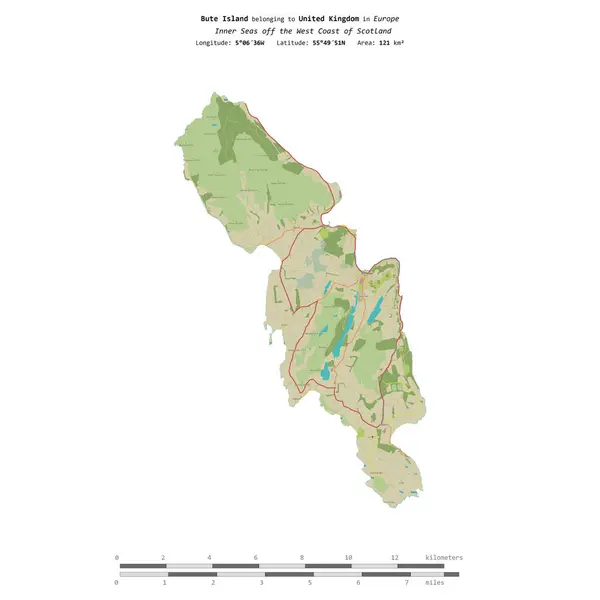
Bute Island In The Inner Seas Off The West Coast Of Scotland, Belonging To United Kingdom, Isolated On A Topographic, OSM Humanitarian Style Map, With Distance Scale
Image, 0.7MB, 2160 × 2160 jpg

Colonsay Island In The Inner Seas Off The West Coast Of Scotland, Belonging To United Kingdom, Isolated On A Topographic, OSM Humanitarian Style Map, With Distance Scale
Image, 0.62MB, 2160 × 2160 jpg

Great Britain Island In The North Sea, Belonging To United Kingdom, Isolated On A Satellite Image Taken In October 1, 2014, With Distance Scale
Image, 1.21MB, 2160 × 2160 jpg

Barra Island In The North Atlantic Ocean On A Topographic, OSM Humanitarian Style Map
Image, 0.84MB, 2880 × 1620 jpg

Benbecula Island In The Inner Seas Off The West Coast Of Scotland, Belonging To United Kingdom, Isolated On A Topographic, OSM Humanitarian Style Map, With Distance Scale
Image, 1.4MB, 2160 × 2160 jpg

Ireland Island In The Celtic Sea, Shared Between: Ireland, United Kingdom, Isolated On A Topographic, OSM Humanitarian Style Map, With Distance Scale
Image, 2.11MB, 2160 × 2160 jpg

Jura Island In The Inner Seas Off The West Coast Of Scotland On A Satellite Image Taken In June 14, 2023
Image, 5.44MB, 2880 × 1620 jpg

Luing Island In The Inner Seas Off The West Coast Of Scotland On A Satellite Image Taken In April 20, 2023
Image, 6MB, 2880 × 1620 jpg

Tiree Island In The Inner Seas Off The West Coast Of Scotland, Belonging To United Kingdom, Isolated On A Topographic, OSM Humanitarian Style Map, With Distance Scale
Image, 0.76MB, 2160 × 2160 jpg

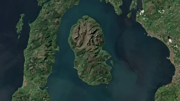
Bute Island In The Inner Seas Off The West Coast Of Scotland On A Colored Elevation Map
Image, 3.11MB, 2880 × 1620 jpg

Tiree Island In The Inner Seas Off The West Coast Of Scotland On A Satellite Image Taken In April 20, 2023
Image, 3.73MB, 2880 × 1620 jpg

Isle Of Rum In The Inner Seas Off The West Coast Of Scotland - Belonging To United Kingdom. Described Location Diagram With Yellow Shape Of The Island And Sample Maps Of Its Surroundings
Image, 2.31MB, 3840 × 2160 jpg

Eigg Island In The Inner Seas Off The West Coast Of Scotland On A Topographic, OSM Humanitarian Style Map
Image, 0.82MB, 2880 × 1620 jpg

South Uist Island In The North Atlantic Ocean, Belonging To United Kingdom, Isolated On A Topographic, OSM Humanitarian Style Map, With Distance Scale
Image, 0.82MB, 2160 × 2160 jpg

Lismore Island In The Inner Seas Off The West Coast Of Scotland On A Colored Elevation Map
Image, 1.85MB, 2880 × 1620 jpg
Isle Of Arran In The Inner Seas Off The West Coast Of Scotland On A Satellite Image Taken In June 14, 2023
Image, 5MB, 2880 × 1620 jpg

Benbecula Island In The Inner Seas Off The West Coast Of Scotland On A Satellite Image Taken In April 25, 2021
Image, 4.9MB, 2880 × 1620 jpg
Page 1 >> Next