photo free
Home Images Vectors Videos

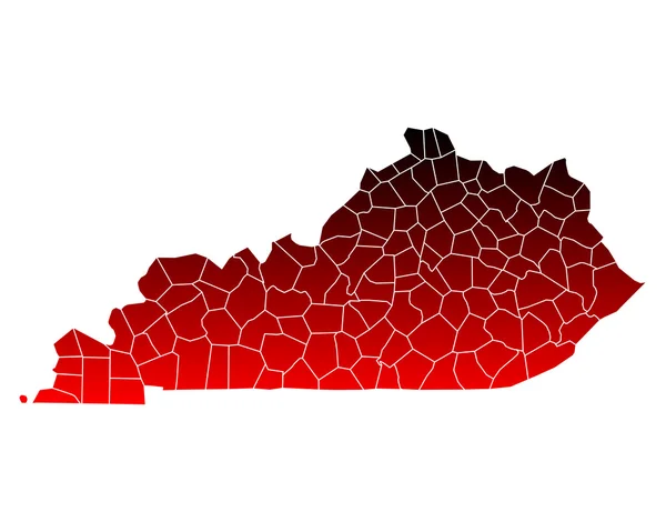
Stock image Kentucky Region

stock vector Accurate map of Kentucky

Accurate Map Of Kentucky

Vector, 0.73MB, 5000 × 4000 eps
stock vector Accurate map of Kentucky

Accurate Map Of Kentucky

Vector, 0.68MB, 5000 × 4000 eps
stock image Kentucky Bluegrass region

Kentucky Bluegrass Region

Image, 14.26MB, 5616 × 3744 jpg
stock vector kentucky

Kentucky

Vector, 2.82MB, 5000 × 4000 eps
stock vector Accurate map of Kentucky

Accurate Map Of Kentucky

Vector, 0.69MB, 5000 × 4000 eps
stock vector Accurate map of Kentucky

Accurate Map Of Kentucky

Vector, 0.73MB, 5000 × 4000 eps
stock image Flag of american state of Kentucky, region of the United States

Flag Of American State Of Kentucky, Region Of The United States

Image, 9.79MB, 7000 × 4000 jpg
stock vector Accurate map of Kentucky

Accurate Map Of Kentucky

Vector, 0.68MB, 5000 × 4000 eps
stock image Green Residential neighborhood in rural Kentucky

Green Residential Neighborhood In Rural Kentucky

Image, 13.36MB, 5472 × 3085 jpg
stock image Rural Kentucky

Rural Kentucky

Image, 15.94MB, 3744 × 5616 jpg
stock vector Kentucky state map silhouette icon

Kentucky State Map Silhouette Icon

Vector, 0.4MB, 5000 × 5000 eps
stock vector Hand sketched KENTUCKY text. 3D vintage, retro lettering for poster, sticker, flyer, header, card, clothing, wear.

Hand Sketched KENTUCKY Text. 3D Vintage, Retro Lettering For Poster, Sticker, Flyer, Header, Card, Clothing, Wear.

Vector, 0.37MB, 6251 × 3132 eps
stock image Kentucky KY USA Flag Stars Stripes Map 3d Illustration

Kentucky KY USA Flag Stars Stripes Map 3d Illustration

Image, 1.96MB, 5000 × 4000 jpg
stock image Moonrise

Moonrise

Image, 15.96MB, 5616 × 3744 jpg
stock vector Missouri, Kentucky, North Carolina, West Virginia, Virginia USA

Missouri, Kentucky, North Carolina, West Virginia, Virginia USA

Vector, 14.48MB, 5000 × 5000 eps
stock vector Kentucky map

Kentucky Map

Vector, 10.66MB, 7002 × 7002 eps
stock vector map of the U.S. state of Kentucky

Map Of The U.S. State Of Kentucky

Vector, 0.6MB, 5000 × 5000 eps
stock image Kentucky Bluegrass

Kentucky Bluegrass

Image, 5.79MB, 3674 × 2449 jpg
stock image Horses at horse farm

Horses At Horse Farm

Image, 4.23MB, 3000 × 2000 jpg
stock image Country road surrounded the horse farms

Country Road Surrounded The Horse Farms

Image, 6MB, 3000 × 2000 jpg
stock image The beautiful pasture of the Kentucky Horse Park in Lexington, Kentucky

The Beautiful Pasture Of The Kentucky Horse Park In Lexington, Kentucky

Image, 16.42MB, 6000 × 4000 jpg
stock image Horse with a foal in the steppes of Kazakhstan near Almaty

Horse With A Foal In The Steppes Of Kazakhstan Near Almaty

Image, 4.07MB, 2738 × 1825 jpg
stock image Residential neighborhood in Kentucky

Residential Neighborhood In Kentucky

Image, 11.63MB, 5472 × 3122 jpg
stock image Kentucky moonrise

Kentucky Moonrise

Image, 13.85MB, 5616 × 3407 jpg
stock image Scenic sunset in the Bluegrass region of Kentucky

Scenic Sunset In The Bluegrass Region Of Kentucky

Image, 22.24MB, 3648 × 5472 jpg
stock image Rain over Kentucky countryside

Rain Over Kentucky Countryside

Image, 10.67MB, 5472 × 2937 jpg
stock image Mammoth Cave National Park

Mammoth Cave National Park

Image, 10.85MB, 4201 × 2763 jpg
stock image Mammoth Cave National Park

Mammoth Cave National Park

Image, 9.36MB, 3909 × 2614 jpg
stock image Mammoth Cave National Park

Mammoth Cave National Park

Image, 8.19MB, 4159 × 2762 jpg
stock image Thuderstorm

Thuderstorm

Image, 9.95MB, 5616 × 3553 jpg
stock image Small lake in Central Kentucky

Small Lake In Central Kentucky

Image, 12.56MB, 3648 × 5472 jpg
stock image The stairs into the entrance at Mammoth Caves

The Stairs Into The Entrance At Mammoth Caves

Image, 35.13MB, 7952 × 5251 jpg
stock vector Modern City Map - Louisville Kentucky city of the USA with neighborhoods and titles outline map

Modern City Map - Louisville Kentucky City Of The USA With Neighborhoods And Titles Outline Map

Vector, 9.82MB, 6529 × 5000 eps
stock image Mammoth Cave National Park

Mammoth Cave National Park

Image, 9.53MB, 2756 × 4142 jpg
stock image Mammoth Cave National Park

Mammoth Cave National Park

Image, 10.35MB, 4242 × 2763 jpg
stock image Mammoth Cave National Park

Mammoth Cave National Park

Image, 12.55MB, 4159 × 2745 jpg
stock image The stairs out of the entrance at Mammoth Caves

The Stairs Out Of The Entrance At Mammoth Caves

Image, 26.16MB, 5033 × 7691 jpg
stock image State flag ball/stamp of UNITED STATES 2/3

State Flag Ball/stamp Of UNITED STATES 2/3

Image, 0.95MB, 2048 × 2560 jpg
stock vector Tennessee, TN, gray political map, with capital Nashville, and with large, important cities. State of Tennessee, located in the Southeastern region of the United States. Nicknamed The Volunteer State.

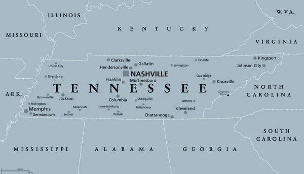
Tennessee, TN, Gray Political Map, With Capital Nashville, And With Large, Important Cities. State Of Tennessee, Located In The Southeastern Region Of The United States. Nicknamed The Volunteer State.

Vector, 2.41MB, 9000 × 5176 eps
stock image Kentucky KY Homes Homes Map New Real Estate Development 3d Illustration

Kentucky KY Homes Homes Map New Real Estate Development 3d Illustration

Image, 3.51MB, 5000 × 4000 jpg
stock vector Kentucky state detailed editable map

Kentucky State Detailed Editable Map

Vector, 0.91MB, 8000 × 3898 eps
stock vector Modern City Map - Lexington-Fayette Kentucky city of the USA with neighborhoods and titles outline

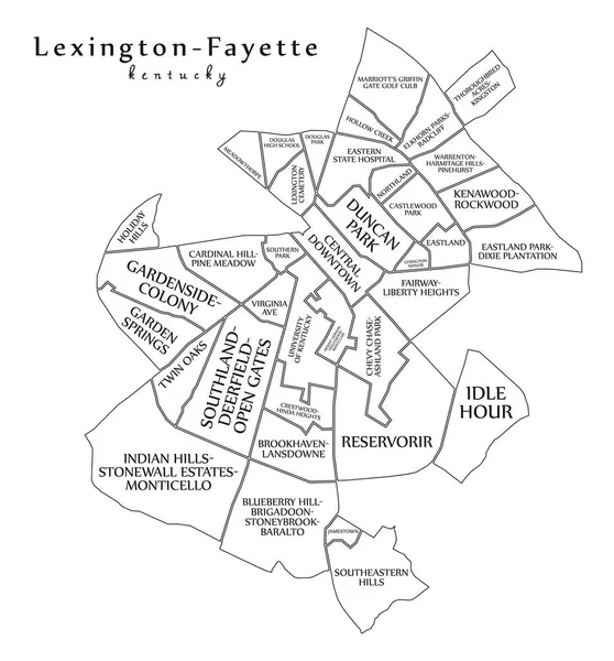
Modern City Map - Lexington-Fayette Kentucky City Of The USA With Neighborhoods And Titles Outline

Vector, 9.59MB, 5000 × 5372 eps
stock image Lexington of Kentucky of United States flag waving

Lexington Of Kentucky Of United States Flag Waving

Image, 0.55MB, 3660 × 2440 jpg
stock vector Vector posters states of the United States with a name, nickname, date admitted to the Union, Division East South Central - Mississippi, Kentucky, Tennessee - set 11 of 17

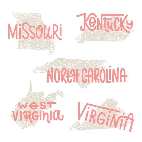
Vector Posters States Of The United States With A Name, Nickname, Date Admitted To The Union, Division East South Central - Mississippi, Kentucky, Tennessee - Set 11 Of 17

Vector, 2.04MB, 8896 × 4168 eps
stock vector Tennessee, TN, political map, with capital Nashville, largest cities, lakes and rivers. State of Tennessee. Landlocked state in Southeastern region of the United States, nicknamed The Volunteer State.

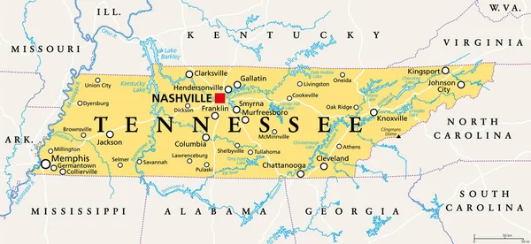
Tennessee, TN, Political Map, With Capital Nashville, Largest Cities, Lakes And Rivers. State Of Tennessee. Landlocked State In Southeastern Region Of The United States, Nicknamed The Volunteer State.

Vector, 4.02MB, 9000 × 4153 eps
stock image Shape of Kentucky, state of Mainland United States, with its capital isolated on white background. Colored elevation map. 3D rendering

Shape Of Kentucky, State Of Mainland United States, With Its Capital Isolated On White Background. Colored Elevation Map. 3D Rendering

Image, 1.78MB, 3836 × 2059 jpg
stock vector Illinois, IL, political map, with capital Springfield and metropolitan area Chicago. State in the Midwestern region of United States, nicknamed Land of Lincoln, Prairie State, and Inland Empire State.

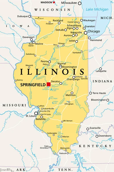
Illinois, IL, Political Map, With Capital Springfield And Metropolitan Area Chicago. State In The Midwestern Region Of United States, Nicknamed Land Of Lincoln, Prairie State, And Inland Empire State.

Vector, 4.08MB, 6000 × 9000 eps
stock vector Set of heart shaped flag of The United States of America with in

Set Of Heart Shaped Flag Of The United States Of America With In

Vector, 8.44MB, 6250 × 4167 eps
stock vector Empty vector map of Louisville, Kentucky, USA

Empty Vector Map Of Louisville, Kentucky, USA

Vector, 5MB, 7168 × 4501 eps
stock vector Indiana, IN, political map, with the capital Indianapolis, and most important cities, rivers and lakes. State in the Midwestern region of the United States of America, nicknamed The Hoosier State.

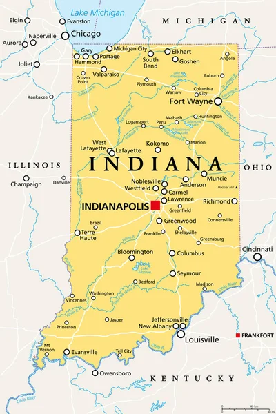
Indiana, IN, Political Map, With The Capital Indianapolis, And Most Important Cities, Rivers And Lakes. State In The Midwestern Region Of The United States Of America, Nicknamed The Hoosier State.

Vector, 3.4MB, 6000 × 9000 eps
Page 1 >> Next