photo free
Home Images Vectors Videos

Stock image Lincoln Boundary

stock vector Lincoln department (Buenos Aires) outline map set

Lincoln Department (Buenos Aires) Outline Map Set

Vector, 0.23MB, 6000 × 3000 eps
stock vector Nebraska line art map

Nebraska Line Art Map

Vector, 2.48MB, 5000 × 5000 eps
stock vector Washington map

Washington Map

Vector, 4.82MB, 5202 × 4787 eps
stock image American state of Nebraska, under lockdown. 3D Rendering

American State Of Nebraska, Under Lockdown. 3D Rendering

Image, 2.5MB, 4500 × 4500 jpg
stock vector Idaho County Map

Idaho County Map

Vector, 0.62MB, 3333 × 5000 ai
stock vector Nebraska state detailed editable map

Nebraska State Detailed Editable Map

Vector, 0.96MB, 7069 × 3773 eps
stock vector Nebraska outline map set

Nebraska Outline Map Set

Vector, 0.27MB, 5079 × 3736 eps
stock vector Nebraska Map Flag. Map of NE, USA with the state flag isolated on white background. United States, America, American, United States of America, US State. Vector illustration.

Nebraska Map Flag. Map Of NE, USA With The State Flag Isolated On White Background. United States, America, American, United States Of America, US State. Vector Illustration.

Vector, 5.85MB, 5000 × 4000 eps
stock vector Nebraska

Nebraska

Vector, 0.82MB, 6692 × 3566 eps
stock image American state of Nebraska, disease quarantine zone. 3D Rendering

American State Of Nebraska, Disease Quarantine Zone. 3D Rendering

Image, 2.68MB, 4500 × 4500 jpg
stock vector Illinois, U.S. state subdivided into 102 counties, gray political map with borders and county names. State in the Midwestern region of USA. Land of Lincoln, Prairie State, and The Inland Empire State.

Illinois, U.S. State Subdivided Into 102 Counties, Gray Political Map With Borders And County Names. State In The Midwestern Region Of USA. Land Of Lincoln, Prairie State, And The Inland Empire State.

Vector, 1.88MB, 5390 × 9000 eps
stock vector Nebraska, U.S. state, subdivided into 93 counties, gray political map with borders and county names. Triply landlocked state in the Midwestern region of United States, nicknamed The Cornhusker State.

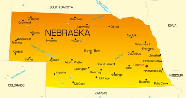
Nebraska, U.S. State, Subdivided Into 93 Counties, Gray Political Map With Borders And County Names. Triply Landlocked State In The Midwestern Region Of United States, Nicknamed The Cornhusker State.

Vector, 1.66MB, 9000 × 4645 eps
stock vector Illinois, U.S. state subdivided into 102 counties, political map with borders and county names. State in the Midwestern region of the USA. Land of Lincoln, Prairie State, and The Inland Empire State.

Illinois, U.S. State Subdivided Into 102 Counties, Political Map With Borders And County Names. State In The Midwestern Region Of The USA. Land Of Lincoln, Prairie State, And The Inland Empire State.

Vector, 2.44MB, 6000 × 9000 eps
stock vector Idaho County Map

Idaho County Map

Vector, 0.62MB, 3332 × 5000 ai
stock vector Nebraska, U.S. state, subdivided into 93 counties,multi colored political map with capital Lincoln, borders and county names.State in the Midwestern region of the United States. The Cornhusker State.

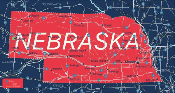
Nebraska, U.S. State, Subdivided Into 93 Counties,multi Colored Political Map With Capital Lincoln, Borders And County Names.State In The Midwestern Region Of The United States. The Cornhusker State.

Vector, 1.68MB, 9000 × 4645 eps
stock vector Nebraska, U.S. state, subdivided into 93 counties, political map with borders and county names. Triply landlocked state in the Midwestern region of United States, nicknamed The Cornhusker State.

Nebraska, U.S. State, Subdivided Into 93 Counties, Political Map With Borders And County Names. Triply Landlocked State In The Midwestern Region Of United States, Nicknamed The Cornhusker State.

Vector, 2.06MB, 9000 × 5220 eps
stock vector The black and white administrative maps of Idaho State, USA

The Black And White Administrative Maps Of Idaho State, USA

Vector, 8.21MB, 6004 × 4428 eps
stock vector Lincoln blank outline map set

Lincoln Blank Outline Map Set

Vector, 0.21MB, 6000 × 3000 eps
Page 1 >> Next