photo free
Home Images Vectors Videos

Stock image Lincoln Sea

stock vector Greenland Political Map

Greenland Political Map

Vector, 1.55MB, 6000 × 7782 eps
stock image Ellesmere Island in the Baffin Bay, belonging to Canada, isolated on a satellite image taken in October 21, 2020, with distance scale

Ellesmere Island In The Baffin Bay, Belonging To Canada, Isolated On A Satellite Image Taken In October 21, 2020, With Distance Scale

Image, 1.64MB, 2160 × 2160 jpg
stock image Ellesmere Island in the Baffin Bay - belonging to Canada. Described location diagram with yellow shape of the island and sample maps of its surroundings

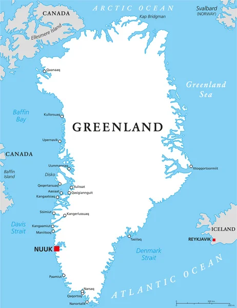
Ellesmere Island In The Baffin Bay - Belonging To Canada. Described Location Diagram With Yellow Shape Of The Island And Sample Maps Of Its Surroundings

Image, 3.3MB, 3840 × 2160 jpg
stock image Ellesmere Island in the Baffin Bay, belonging to Canada, isolated on a bilevel elevation map, with distance scale

Ellesmere Island In The Baffin Bay, Belonging To Canada, Isolated On A Bilevel Elevation Map, With Distance Scale

Image, 0.84MB, 2160 × 2160 jpg
stock image Ellesmere Island in the Baffin Bay on a topographic, OSM Humanitarian style map

Ellesmere Island In The Baffin Bay On A Topographic, OSM Humanitarian Style Map

Image, 1.43MB, 2880 × 1620 jpg
stock image Ellesmere Island in the Baffin Bay, belonging to Canada, isolated on a topographic, OSM Humanitarian style map, with distance scale

Ellesmere Island In The Baffin Bay, Belonging To Canada, Isolated On A Topographic, OSM Humanitarian Style Map, With Distance Scale

Image, 0.79MB, 2160 × 2160 jpg
stock image Ellesmere Island in the Baffin Bay on a satellite image taken in December 31, 2014

Ellesmere Island In The Baffin Bay On A Satellite Image Taken In December 31, 2014

Image, 3.64MB, 2880 × 1620 jpg
stock image Ellesmere Island in the Baffin Bay on a colored elevation map

Ellesmere Island In The Baffin Bay On A Colored Elevation Map

Image, 3.72MB, 2880 × 1620 jpg
stock image Olive green ocean wave during summer tide, abstract sea nature

Olive Green Ocean Wave During Summer Tide, Abstract Sea Nature

Image, 4.71MB, 2028 × 3043 jpg
stock image Olive green ocean wave during summer tide

Olive Green Ocean Wave During Summer Tide

Image, 4.98MB, 3053 × 2035 jpg
stock image Splashing Water in Pool with Shadow

Splashing Water In Pool With Shadow

Image, 16.26MB, 5472 × 3648 jpg
stock image Ship wreck

Ship Wreck

Image, 12.69MB, 4500 × 3000 jpg
stock image Designs in sand with dramatic sky

Designs In Sand With Dramatic Sky

Image, 9.39MB, 2695 × 4057 jpg
stock image Memorial monument crashed and killed Allied airmen World War II

Memorial Monument Crashed And Killed Allied Airmen World War II

Image, 9.36MB, 6000 × 4000 jpg
stock image Worn path in the sand over the dune

Worn Path In The Sand Over The Dune

Image, 12.65MB, 3346 × 4183 jpg
stock image Worn path in the sand over the dune

Worn Path In The Sand Over The Dune

Image, 15.18MB, 4588 × 3051 jpg
stock image Coast area

Coast Area

Image, 4.5MB, 3008 × 2000 jpg
stock image Seagulls on a Beach

Seagulls On A Beach

Image, 5.98MB, 3560 × 2358 jpg
stock image Port Lincoln  in South Australia

Port Lincoln In South Australia

Image, 9.38MB, 5406 × 2699 jpg
stock image Driftwood covered beach at Lincoln City, Oregon

Driftwood Covered Beach At Lincoln City, Oregon

Image, 0MB, 4928 × 3264 jpg
stock image Aerial view of Pemaquid Point Light

Aerial View Of Pemaquid Point Light

Image, 13.79MB, 5431 × 3055 jpg
stock image surf at lincoln beach

Surf At Lincoln Beach

Image, 0MB, 2880 × 1920 jpg
stock image Coast area

Coast Area

Image, 4.77MB, 3008 × 2000 jpg
stock image A veiw of the West Seattle shoreline from Lincoln Park.

A Veiw Of The West Seattle Shoreline From Lincoln Park.

Image, 11.18MB, 5688 × 3486 jpg
stock image Tuna fish swims - Bluefin tuna Thunnus thynnus underwater swimming

Tuna Fish Swims - Bluefin Tuna Thunnus Thynnus Underwater Swimming

Image, 4.93MB, 4272 × 2848 jpg
stock image A veiw of the West Seattle shoreline from Lincoln Park.

A Veiw Of The West Seattle Shoreline From Lincoln Park.

Image, 10.69MB, 5848 × 3378 jpg
stock image Tuna

Tuna

Image, 4.99MB, 3264 × 2448 jpg
stock image Tuna

Tuna

Image, 6.32MB, 3069 × 2302 jpg
stock image Blue-fin Tuna

Blue-fin Tuna

Image, 6.38MB, 3648 × 2736 jpg
stock image Siletz Bay

Siletz Bay

Image, 3.74MB, 3008 × 2000 jpg
stock image Blue-fin Tuna

Blue-fin Tuna

Image, 7.54MB, 3648 × 2736 jpg
stock image Blue-fin Tuna

Blue-fin Tuna

Image, 6.13MB, 3648 × 2736 jpg
stock image Blue-fin Tuna

Blue-fin Tuna

Image, 7.28MB, 3613 × 2409 jpg
stock image Newport Marina

Newport Marina

Image, 15.08MB, 5616 × 3744 jpg
stock image Blue-fin Tuna

Blue-fin Tuna

Image, 5.98MB, 3648 × 2736 jpg
stock image Blue-fin Tuna

Blue-fin Tuna

Image, 4.5MB, 3468 × 2312 jpg
stock image Danger Sign

Danger Sign

Image, 4.44MB, 5220 × 3480 jpg
stock image Blue-fin Tuna

Blue-fin Tuna

Image, 5.04MB, 3282 × 2188 jpg
stock image Walking trail

Walking Trail

Image, 4.85MB, 3008 × 2000 jpg
stock image Seals sleep on the stone

Seals Sleep On The Stone

Image, 11.39MB, 5616 × 3744 jpg
stock image The Pemaquid Point lighthouse

The Pemaquid Point Lighthouse

Image, 14.99MB, 5760 × 3840 jpg
stock image The Lincoln Park Steps, San Francisco

The Lincoln Park Steps, San Francisco

Image, 19.52MB, 6000 × 4000 jpg
stock vector US Coast Guard flag, United States of America, vector illustration

US Coast Guard Flag, United States Of America, Vector Illustration

Vector, 7.93MB, 7000 × 7000 eps
stock image The Pemaquid Point lighthouse

The Pemaquid Point Lighthouse

Image, 15.36MB, 5760 × 3840 jpg
stock vector US Navy official flag, United States, vector illustration

US Navy Official Flag, United States, Vector Illustration

Vector, 12.9MB, 6500 × 6500 eps
stock vector High detailed Nebraska physical map.

High Detailed Nebraska Physical Map.

Vector, 6.12MB, 6902 × 4035 eps
stock image A view of the scenic shoreline in Lincoln City, Oregon.

A View Of The Scenic Shoreline In Lincoln City, Oregon.

Image, 13.05MB, 7595 × 5031 jpg
stock image Yachats River in Yachats, Central OREGON COAST.

Yachats River In Yachats, Central OREGON COAST.

Image, 27.58MB, 8241 × 5494 jpg
stock image Michael McDowell gets ready to qualify for the GEICO 500 in Lincoln, AL, USA

Michael McDowell Gets Ready To Qualify For The GEICO 500 In Lincoln, AL, USA

Image, 14.25MB, 8192 × 5464 jpg
stock image Lincoln House Point and luxurious coastal mansions aerial view between Fishermans Beach and Eisman's Beach in town of Swampscott, Massachusetts MA, USA.

Lincoln House Point And Luxurious Coastal Mansions Aerial View Between Fishermans Beach And Eisman's Beach In Town Of Swampscott, Massachusetts MA, USA.

Image, 7.61MB, 3992 × 2700 jpg
Page 1 >> Next