
Stock image Oshima Island page 2

Isla Del Otro Lado In The North Pacific Ocean - Belonging To Mexico. Described Location Diagram With Yellow Shape Of The Island And Sample Maps Of Its Surroundings
Image, 2.04MB, 3840 × 2160 jpg

Ovalau Island In The South Pacific Ocean, Belonging To Fiji, Isolated On A Bilevel Elevation Map, With Distance Scale
Image, 0.42MB, 2160 × 2160 jpg

Amamioshima Island In The Eastern China Sea, Belonging To Japan, Isolated On A Bilevel Elevation Map, With Distance Scale
Image, 0.55MB, 2160 × 2160 jpg

Isla Del Otro Lado In The North Pacific Ocean, Belonging To Mexico, Isolated On A Topographic, OSM Humanitarian Style Map, With Distance Scale
Image, 0.28MB, 2160 × 2160 jpg

Ile Ouen In The Coral Sea, Belonging To France, Isolated On A Topographic, OSM Humanitarian Style Map, With Distance Scale
Image, 0.54MB, 2160 × 2160 jpg
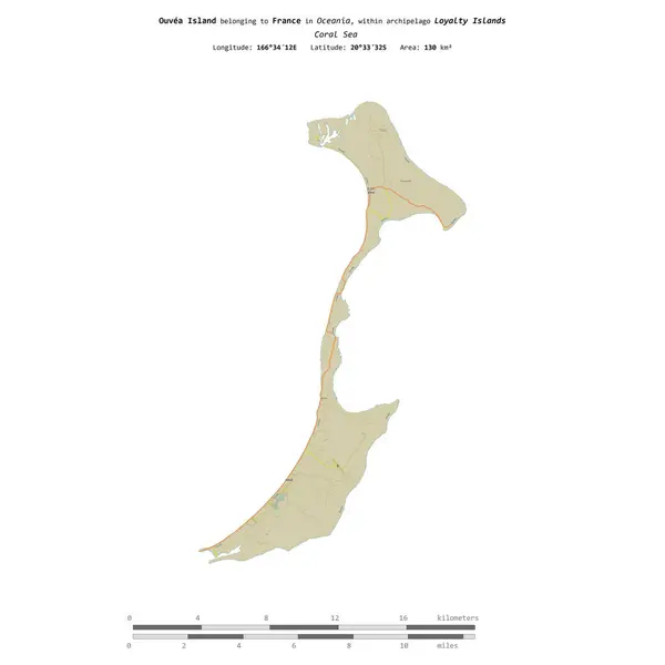
Ouvea Island In The Coral Sea, Belonging To France, Isolated On A Topographic, OSM Humanitarian Style Map, With Distance Scale
Image, 0.36MB, 2160 × 2160 jpg

Ouvea Island In The Coral Sea - Belonging To France. Described Location Diagram With Yellow Shape Of The Island And Sample Maps Of Its Surroundings
Image, 1.79MB, 3840 × 2160 jpg

Amamioshima Island In The Eastern China Sea, Belonging To Japan, Isolated On A Topographic, OSM Humanitarian Style Map, With Distance Scale
Image, 0.69MB, 2160 × 2160 jpg

Ovalau Island In The South Pacific Ocean, Belonging To Fiji, Isolated On A Topographic, OSM Humanitarian Style Map, With Distance Scale
Image, 0.5MB, 2160 × 2160 jpg

Ile De L'Ouest In The Indian Ocean - Belonging To French Southern And Antarctic Lands. Described Location Diagram With Yellow Shape Of The Island And Sample Maps Of Its Surroundings
Image, 2.56MB, 3840 × 2160 jpg

Ile De L'Ouest In The Indian Ocean, Belonging To French Southern And Antarctic Lands, Isolated On A Bilevel Elevation Map, With Distance Scale
Image, 0.33MB, 2160 × 2160 jpg

Ovalau Island In The South Pacific Ocean - Belonging To Fiji. Described Location Diagram With Yellow Shape Of The Island And Sample Maps Of Its Surroundings
Image, 1.77MB, 3840 × 2160 jpg

Amamioshima Island In The Eastern China Sea On A Topographic, OSM Humanitarian Style Map
Image, 0.88MB, 2880 × 1620 jpg

Ile Ouen In The Coral Sea, Belonging To France, Isolated On A Bilevel Elevation Map, With Distance Scale
Image, 0.37MB, 2160 × 2160 jpg

Ile De L'Ouest In The Indian Ocean, Belonging To French Southern And Antarctic Lands, Isolated On A Topographic, OSM Humanitarian Style Map, With Distance Scale
Image, 0.45MB, 2160 × 2160 jpg

Ouvea Island In The Coral Sea, Belonging To France, Isolated On A Bilevel Elevation Map, With Distance Scale
Image, 0.27MB, 2160 × 2160 jpg
Previous << Page 2 >> Next