photo free
Home Images Vectors Videos

Stock image Paracel

stock vector South China Sea Islands political map

South China Sea Islands Political Map

Vector, 3.66MB, 7209 × 8888 eps
stock vector Peoples Republic of China, PRC, political map. Area controlled by China in yellow, and claimed but uncontrolled regions shown in orange. Capitals and borders. English labeling. Illustration. Vector.

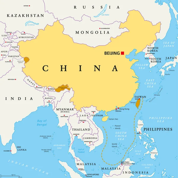
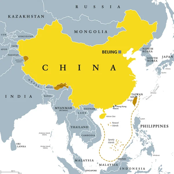
Peoples Republic Of China, PRC, Political Map. Area Controlled By China In Yellow, And Claimed But Uncontrolled Regions Shown In Orange. Capitals And Borders. English Labeling. Illustration. Vector.

Vector, 5.31MB, 8033 × 8033 eps
stock vector Hainan, southernmost province of China, and surrounding area, gray political map. Hainan Island, and Paracel Islands in the South China Sea, south of the Leizhou Peninsula, and east of Gulf of Tonkin.

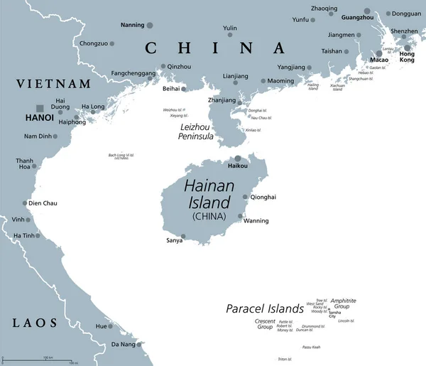
Hainan, Southernmost Province Of China, And Surrounding Area, Gray Political Map. Hainan Island, And Paracel Islands In The South China Sea, South Of The Leizhou Peninsula, And East Of Gulf Of Tonkin.

Vector, 3.25MB, 6979 × 6000 eps
stock vector Symbol Map of the  Paracel Islands (People's Republic of China). Abstract map showing the state/province with a pattern of overlapping colorful squares like candies

Symbol Map Of The Paracel Islands (People's Republic Of China). Abstract Map Showing The State/province With A Pattern Of Overlapping Colorful Squares Like Candies

Vector, 0.56MB, 6000 × 4797 eps
stock vector Flag of China in the country outline. Area controlled by the Peoples Republic of China, PRC, and claimed but uncontrolled regions. Five-star Red Flag. Isolated illustration on white background. Vector

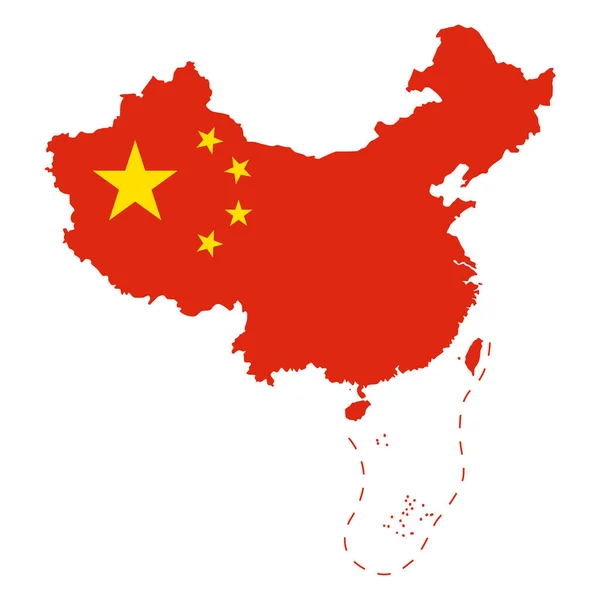
Flag Of China In The Country Outline. Area Controlled By The Peoples Republic Of China, PRC, And Claimed But Uncontrolled Regions. Five-star Red Flag. Isolated Illustration On White Background. Vector

Vector, 2.54MB, 8033 × 8033 eps
stock vector Symbol Map of the  Paracel Islands (People's Republic of China). Abstract map showing the state/province with horizontal parallel lines in rainbow colors

Symbol Map Of The Paracel Islands (People's Republic Of China). Abstract Map Showing The State/province With Horizontal Parallel Lines In Rainbow Colors

Vector, 0.56MB, 6000 × 4797 eps
stock vector Disputed Territory within the area of The Philippines, China and Vietnam. Editable Clip Art.

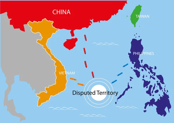
Disputed Territory Within The Area Of The Philippines, China And Vietnam. Editable Clip Art.

Vector, 1.54MB, 5781 × 4099 eps
stock image Nha Trang, Vietnam - February 5, 2016: A propaganda poster about protecting the Spratly islands in the square in Vietnam

Nha Trang, Vietnam - February 5, 2016: A Propaganda Poster About Protecting The Spratly Islands In The Square In Vietnam

Image, 6.42MB, 4288 × 2848 jpg
stock image --FILE--An aerial view of Sansha city on Yongxing Island of the Xisha Islands, also known as the Paracel Islands, in South China Sea, 30 November 2011

--FILE--An Aerial View Of Sansha City On Yongxing Island Of The Xisha Islands, Also Known As The Paracel Islands, In South China Sea, 30 November 2011

Image, 2.33MB, 3456 × 2304 jpg
stock image Nha Trang, Vietnam - July 11, 2015: A propaganda poster about protecting the Spratly islands in the square in Vietnam

Nha Trang, Vietnam - July 11, 2015: A Propaganda Poster About Protecting The Spratly Islands In The Square In Vietnam

Image, 4.8MB, 4288 × 2848 jpg
stock image Nha Trang, Vietnam - February 5, 2016: A propaganda poster about protecting the Spratly islands in the square in Vietnam

Nha Trang, Vietnam - February 5, 2016: A Propaganda Poster About Protecting The Spratly Islands In The Square In Vietnam

Image, 5.38MB, 4288 × 2848 jpg
stock image Flags of Japan and USA waving with cloudy blue sky background, 3D redering United States of America, Chinese Communist Party CCP.

Flags Of Japan And USA Waving With Cloudy Blue Sky Background, 3D Redering United States Of America, Chinese Communist Party CCP.

Image, 7.9MB, 5184 × 3456 jpg
stock vector Peoples Republic of China, PRC, gray political map. Area controlled by China in yellow color, and claimed but uncontrolled regions shown in brown. English labeling. Illustration over white. Vector.

Peoples Republic Of China, PRC, Gray Political Map. Area Controlled By China In Yellow Color, And Claimed But Uncontrolled Regions Shown In Brown. English Labeling. Illustration Over White. Vector.

Vector, 4.41MB, 8033 × 8033 eps
stock vector China Usa 01 Infographic Isometric

China Usa 01 Infographic Isometric

Vector, 0.28MB, 5556 × 5556 ai
stock image A view of one of the Paracel Islands

A View Of One Of The Paracel Islands

Image, 1.12MB, 3013 × 2008 jpg
stock vector Vietnam map with detail of islands, provinces name and border with 3 main areas (Northern, Central and Southern)

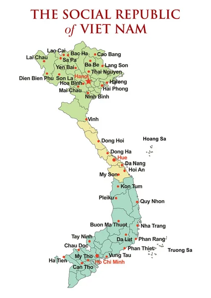
Vietnam Map With Detail Of Islands, Provinces Name And Border With 3 Main Areas (Northern, Central And Southern)

Vector, 1.55MB, 3720 × 5262 eps
stock vector South China Sea Islands, political map. Islands, atolls, cays, shoals, reefs and sandbars. Partially claimed by China and other neighboring states. Paracel and Spratly Islands. Illustration. Vector.

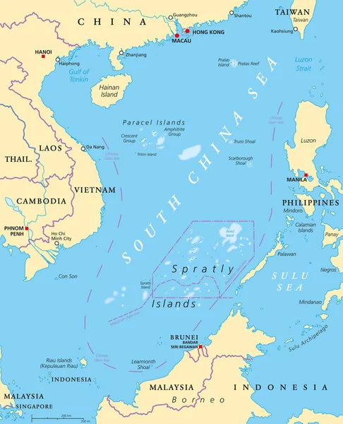
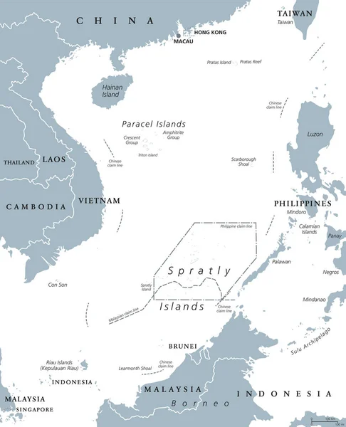
South China Sea Islands, Political Map. Islands, Atolls, Cays, Shoals, Reefs And Sandbars. Partially Claimed By China And Other Neighboring States. Paracel And Spratly Islands. Illustration. Vector.

Vector, 6.6MB, 7165 × 8833 eps
stock image Nha Trang, Vietnam - July 11, 2015: A propaganda poster about protecting the Spratly islands in the square in Vietnam

Nha Trang, Vietnam - July 11, 2015: A Propaganda Poster About Protecting The Spratly Islands In The Square In Vietnam

Image, 4.84MB, 4288 × 2848 jpg
stock image Flags of China and Taiwan waving with cloudy blue sky background, 3D redering United States of America, Chinese Communist Party CCP.

Flags Of China And Taiwan Waving With Cloudy Blue Sky Background, 3D Redering United States Of America, Chinese Communist Party CCP.

Image, 9.01MB, 5184 × 3456 jpg
stock image Quang Ngai, Vietnam - July 5, 2012: Fishing boats are mooring together in the sea

Quang Ngai, Vietnam - July 5, 2012: Fishing Boats Are Mooring Together In The Sea

Image, 7.21MB, 4288 × 2848 jpg
stock image --FILE--An aerial view of Sansha city on Yongxing Island of the Xisha Islands, also known as the Paracel Islands, in South China Sea, 16 July 2014

--FILE--An Aerial View Of Sansha City On Yongxing Island Of The Xisha Islands, Also Known As The Paracel Islands, In South China Sea, 16 July 2014

Image, 1.79MB, 4982 × 3378 jpg
Page 1 >> Next