photo free
Home Images Vectors Videos

Stock image Rutland County

stock image Lake Bomoseen landscape timelapse night starscape horizon

Lake Bomoseen Landscape Timelapse Night Starscape Horizon

Image, 8.49MB, 4810 × 3207 jpg
stock vector Map of Vermont

Map Of Vermont

Vector, 0.4MB, 4655 × 5000 ai
stock vector Vermont County Map

Vermont County Map

Vector, 0.55MB, 3332 × 5000 ai
stock image Normanton Church in Rutland

Normanton Church In Rutland

Image, 5.32MB, 3800 × 2533 jpg
stock vector Coat of arms of Rutland in England

Coat Of Arms Of Rutland In England

Vector, 4.18MB, 3937 × 6010 eps
stock image The Buttercross in Oakham

The Buttercross In Oakham

Image, 5.9MB, 3400 × 2267 jpg
stock vector Vermont, U.S. state, subdivided into 14 counties, political map with borders and county names. State in the New England region of the Northeastern United States, nicknamed The Green Mountain State.

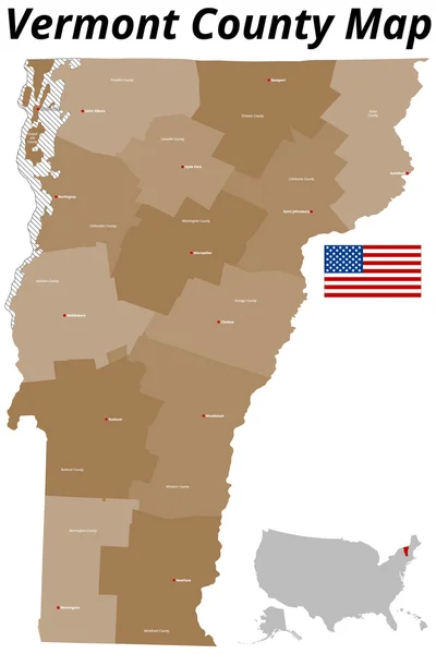
Vermont, U.S. State, Subdivided Into 14 Counties, Political Map With Borders And County Names. State In The New England Region Of The Northeastern United States, Nicknamed The Green Mountain State.

Vector, 1.89MB, 5855 × 9000 eps
stock vector Vermont, U.S. state, subdivided into 14 counties, gray political map with borders and county names. State in the New England region of Northeastern United States, nicknamed The Green Mountain State.

Vermont, U.S. State, Subdivided Into 14 Counties, Gray Political Map With Borders And County Names. State In The New England Region Of Northeastern United States, Nicknamed The Green Mountain State.

Vector, 1.51MB, 6000 × 9000 eps
stock vector Vermont, U.S. state, subdivided into 14 counties, multi colored political map with capital Montpelier, borders and county names. State in the New England region of United States. Green Mountain State.

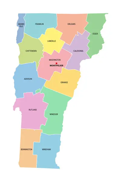
Vermont, U.S. State, Subdivided Into 14 Counties, Multi Colored Political Map With Capital Montpelier, Borders And County Names. State In The New England Region Of United States. Green Mountain State.

Vector, 1.52MB, 6000 × 9000 eps
stock vector Rutland map, ceremonial county of England. Vector illustration.

Rutland Map, Ceremonial County Of England. Vector Illustration.

Vector, 5.31MB, 8334 × 8334 eps
Page 1 >> Next