photo free
Home Images Vectors Videos

Stock image Sorveying

stock image Cropped shot of smiling surveyor writing on clipboard beside digital level

Cropped Shot Of Smiling Surveyor Writing On Clipboard Beside Digital Level

Image, 16.69MB, 6913 × 4614 jpg
stock image Surveyor works with theodolite

Surveyor Works With Theodolite

Image, 11.89MB, 6050 × 4038 jpg
stock image Side view of surveyor with digital level measuring field

Side View Of Surveyor With Digital Level Measuring Field

Image, 8.46MB, 7360 × 4912 jpg
stock image Geodesist measure land speak transmitter

Geodesist Measure Land Speak Transmitter

Image, 8.33MB, 6048 × 4032 jpg
stock image Smiling surveyor holding clipboard and digital level

Smiling Surveyor Holding Clipboard And Digital Level

Image, 15.78MB, 7360 × 4912 jpg
stock image Detail of architectural documents.

Detail Of Architectural Documents.

Image, 5.38MB, 4992 × 3328 jpg
stock image Surveyor looking throughout digital level on construction site

Surveyor Looking Throughout Digital Level On Construction Site

Image, 13.75MB, 7360 × 4912 jpg
stock image Surveyor engineer making measure with partner on the field

Surveyor Engineer Making Measure With Partner On The Field

Image, 11.73MB, 5616 × 3744 jpg
stock image Selective focus of surveyor with ruler and colleague with digital level in field

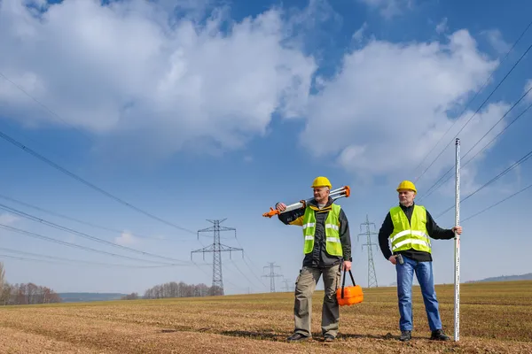
Selective Focus Of Surveyor With Ruler And Colleague With Digital Level In Field

Image, 10.08MB, 7360 × 4912 jpg
stock image Surveying

Surveying

Image, 7.8MB, 3888 × 2592 jpg
stock image Surveyor holding digital level with field and construction site at background

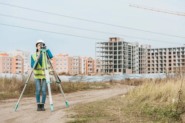
Surveyor Holding Digital Level With Field And Construction Site At Background

Image, 9.43MB, 7360 × 4912 jpg
stock image Geodesist measure land on construction site

Geodesist Measure Land On Construction Site

Image, 8.69MB, 6048 × 4032 jpg
stock image Surveyor with digital tablet and measuring level smiling at camera

Surveyor With Digital Tablet And Measuring Level Smiling At Camera

Image, 7.99MB, 7360 × 4912 jpg
stock image Theodolite survey outdoors

Theodolite Survey Outdoors

Image, 7.24MB, 4372 × 2000 jpg
stock image Female surveyor working with digital level in field

Female Surveyor Working With Digital Level In Field

Image, 9.93MB, 4912 × 7360 jpg
stock image Geodesist is working with total station on a building site. Civi

Geodesist Is Working With Total Station On A Building Site. Civi

Image, 9.68MB, 5184 × 3456 jpg
stock image Surveyor looking through digital level in field

Surveyor Looking Through Digital Level In Field

Image, 8MB, 7360 × 4912 jpg
stock image Surveyor engineer with partner making measure on the field

Surveyor Engineer With Partner Making Measure On The Field

Image, 6.67MB, 5616 × 3744 jpg
stock image Surveyor measuring land with digital level on construction site

Surveyor Measuring Land With Digital Level On Construction Site

Image, 7.98MB, 6937 × 4630 jpg
stock vector Land Surveyor Logo

Land Surveyor Logo

Vector, 1.36MB, 4000 × 5000 eps
stock image Surveyor holding digital level with construction site at background

Surveyor Holding Digital Level With Construction Site At Background

Image, 11.71MB, 4912 × 7360 jpg
stock vector Caucasian surveyor builder working with theodolite

Caucasian Surveyor Builder Working With Theodolite

Vector, 3.88MB, 4583 × 6667 eps
stock image Smiling surveyor with digital level looking at camera

Smiling Surveyor With Digital Level Looking At Camera

Image, 17.83MB, 7360 × 4912 jpg
stock vector GPS Surveyor Logo

GPS Surveyor Logo

Vector, 2.41MB, 4000 × 5000 eps
stock image Surveyor with clipboard looking throughout digital level

Surveyor With Clipboard Looking Throughout Digital Level

Image, 18.4MB, 4912 × 7360 jpg
stock image Geodesist two man equipment on construction site

Geodesist Two Man Equipment On Construction Site

Image, 10.26MB, 5983 × 3989 jpg
stock image Side view of surveyor with digital level looking away

Side View Of Surveyor With Digital Level Looking Away

Image, 5.93MB, 6910 × 4612 jpg
stock image Surveyor  Engineering on Land

Surveyor Engineering On Land

Image, 4.35MB, 7360 × 4912 jpg
stock image Smiling surveyor looking through digital level and showing thumb up gesture

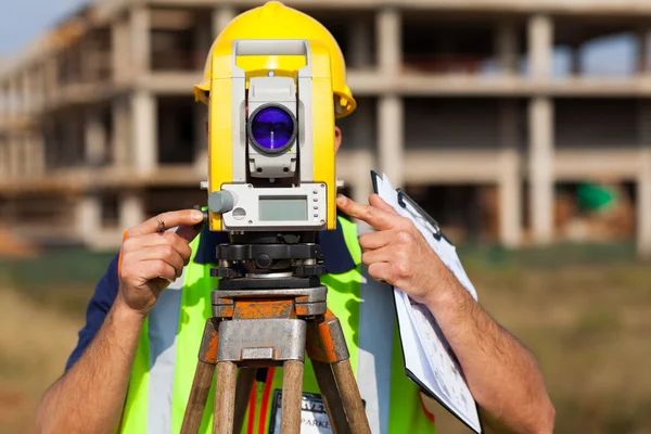
Smiling Surveyor Looking Through Digital Level And Showing Thumb Up Gesture

Image, 9.52MB, 7360 × 4912 jpg
stock image Surveyor equipment theodolite at construction site

Surveyor Equipment Theodolite At Construction Site

Image, 5.42MB, 4230 × 2815 jpg
stock image Smiling Surveyor looking through digital level

Smiling Surveyor Looking Through Digital Level

Image, 7.14MB, 7012 × 4680 jpg
stock image Surveyor works with theodolite

Surveyor Works With Theodolite

Image, 5.09MB, 4230 × 2815 jpg
stock image Surveyor with digital tablet looking through measuring level

Surveyor With Digital Tablet Looking Through Measuring Level

Image, 7.27MB, 4912 × 7360 jpg
stock image Surveyor engineer making measure on the field with tablet pc

Surveyor Engineer Making Measure On The Field With Tablet Pc

Image, 10.54MB, 5616 × 3744 jpg
stock image Female surveyor with radio set looking through digital level

Female Surveyor With Radio Set Looking Through Digital Level

Image, 7.89MB, 7360 × 4912 jpg
stock image Surveyor engineer making measure with cloud background

Surveyor Engineer Making Measure With Cloud Background

Image, 6.44MB, 5616 × 3744 jpg
stock image Surveyor with digital level smiling at camera with building materials at background

Surveyor With Digital Level Smiling At Camera With Building Materials At Background

Image, 8.33MB, 7360 × 4912 jpg
stock image land surveyor looking through theodolite

Land Surveyor Looking Through Theodolite

Image, 8.79MB, 5616 × 3744 jpg
stock image Back view of surveyor working with digital level in field

Back View Of Surveyor Working With Digital Level In Field

Image, 9.73MB, 4912 × 7360 jpg
stock image Land plot in aerial view. Gps registration survey of property, real estate for map with location, area. Concept for residential construction and development. Also home, house for sale, buy, purchase.

Land Plot In Aerial View. Gps Registration Survey Of Property, Real Estate For Map With Location, Area. Concept For Residential Construction And Development. Also Home, House For Sale, Buy, Purchase.

Image, 14.04MB, 5464 × 3640 jpg
stock image Smiling surveyor with digital level talking on radio set

Smiling Surveyor With Digital Level Talking On Radio Set

Image, 14.04MB, 7035 × 4695 jpg
stock image Imaginary cadastral map with buildings, land parcel, vacant plot and roads

Imaginary Cadastral Map With Buildings, Land Parcel, Vacant Plot And Roads

Image, 13.34MB, 5751 × 4147 jpg
stock image Surveyor holding clipboard and digital level and smiling at camera on construction site

Surveyor Holding Clipboard And Digital Level And Smiling At Camera On Construction Site

Image, 19.43MB, 4912 × 7360 jpg
stock image Planning a new city - concept image with an imaginary cadastral map of territory with buildings, land parcel and 3D rendering of Tablet device and geodesic device, called Total Station, used to survey and draw topographic maps.

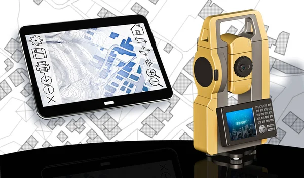
Planning A New City - Concept Image With An Imaginary Cadastral Map Of Territory With Buildings, Land Parcel And 3D Rendering Of Tablet Device And Geodesic Device, Called Total Station, Used To Survey And Draw Topographic Maps.

Image, 11.09MB, 7547 × 4432 jpg
stock image Side view of Surveyor measuring land with digital level

Side View Of Surveyor Measuring Land With Digital Level

Image, 6.76MB, 7360 × 4912 jpg
stock image Buildings Permit concept with imaginary cadastral on digital tablet - building activity and construction industry with General Urban Plan

Buildings Permit Concept With Imaginary Cadastral On Digital Tablet - Building Activity And Construction Industry With General Urban Plan

Image, 17.49MB, 5760 × 3840 jpg
stock image Side view of Surveyor working with digital level

Side View Of Surveyor Working With Digital Level

Image, 6.7MB, 7360 × 4912 jpg
stock image Surveying device on site ready to work

Surveying Device On Site Ready To Work

Image, 12.57MB, 6000 × 4000 jpg
stock image Smiling surveyor with digital level showing thumb up gesture

Smiling Surveyor With Digital Level Showing Thumb Up Gesture

Image, 8.45MB, 7360 × 4912 jpg
stock vector Surveyors line icons, signs, vector set, linear concept, outline illustration

Surveyors Line Icons, Signs, Vector Set, Linear Concept, Outline Illustration

Vector, 2.32MB, 6000 × 6000 eps
Page 1 >> Next