photo free
Home Images Vectors Videos

Stock image Tocantins page 2

stock image Red dunes at Jalapao, one of wildest areas in Brazil

Red Dunes At Jalapao, One Of Wildest Areas In Brazil

Image, 11.41MB, 5113 × 3402 jpg
stock image Red dunes at Jalapao, one of wildest areas in Brazil

Red Dunes At Jalapao, One Of Wildest Areas In Brazil

Image, 12.93MB, 5113 × 3402 jpg
stock image Flag of Tocantins, Brazil

Flag Of Tocantins, Brazil

Image, 2.47MB, 3072 × 1920 jpg
stock image Aerial View of Rural Area in Brazil

Aerial View Of Rural Area In Brazil

Image, 12.18MB, 5373 × 3579 jpg
stock image Red dunes at Jalapao, one of wildest areas in Brazil

Red Dunes At Jalapao, One Of Wildest Areas In Brazil

Image, 12.7MB, 5113 × 3402 jpg
stock image Waving Flag of Tocantins State, Brazil

Waving Flag Of Tocantins State, Brazil

Image, 10.38MB, 5184 × 3456 jpg
stock image tocantins on map of brazil

Tocantins On Map Of Brazil

Image, 27.4MB, 4456 × 4056 jpg
stock vector Tocantins blank outline map set

Tocantins Blank Outline Map Set

Vector, 0.38MB, 3829 × 5878 eps
stock vector tocantins administrative and political map with flag

Tocantins Administrative And Political Map With Flag

Vector, 0.67MB, 3100 × 4870 eps
stock image Red dunes at Jalapao, one of wildest areas in Brazil

Red Dunes At Jalapao, One Of Wildest Areas In Brazil

Image, 12.66MB, 3402 × 5113 jpg
stock vector Map of Tocantins

Map Of Tocantins

Vector, 0.68MB, 4000 × 5000 eps
stock vector road vector map of the brazilian state tocantins

Road Vector Map Of The Brazilian State Tocantins

Vector, 1.45MB, 3100 × 4861 eps
stock image Map of Tocantins. Brazil.

Map Of Tocantins. Brazil.

Image, 1.44MB, 5600 × 4200 jpg
stock image Flag of Palmas, Tocantins, Brazil, old postage stamp

Flag Of Palmas, Tocantins, Brazil, Old Postage Stamp

Image, 15.81MB, 4500 × 3000 jpg
stock image Tocantins, state of Brazil. Elevation map colored in wiki style with lakes and rivers. Locations of major cities of the region. Corner auxiliary location maps

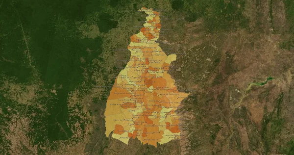
Tocantins, State Of Brazil. Elevation Map Colored In Wiki Style With Lakes And Rivers. Locations Of Major Cities Of The Region. Corner Auxiliary Location Maps

Image, 10.37MB, 4930 × 3770 jpg
stock image Galaxy pleco (Leporacanthicus galaxias)

Galaxy Pleco (Leporacanthicus Galaxias)

Image, 4.01MB, 5498 × 3665 jpg
stock vector Map of Tocantins 2018

Map Of Tocantins 2018

Vector, 0.69MB, 4000 × 5000 eps
stock image Red dunes at Jalapao, one of wildest areas in Brazil

Red Dunes At Jalapao, One Of Wildest Areas In Brazil

Image, 10.64MB, 5113 × 3402 jpg
stock image Porto Nacional, Tocantins, Brazil, June 21, 2011. Cathedral of Our Lady of Mercy, National Harbor. National Harbor is a municipality in the Brazilian state of Tocantins.

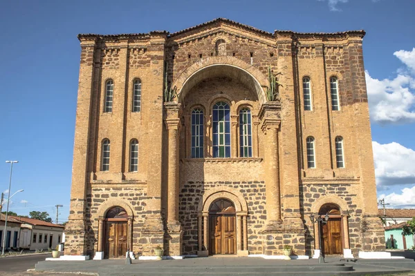
Porto Nacional, Tocantins, Brazil, June 21, 2011. Cathedral Of Our Lady Of Mercy, National Harbor. National Harbor Is A Municipality In The Brazilian State Of Tocantins.

Image, 7.55MB, 3888 × 2592 jpg
stock image A natural arch in Jalapao State Park in the state of Tocantins, Brazil

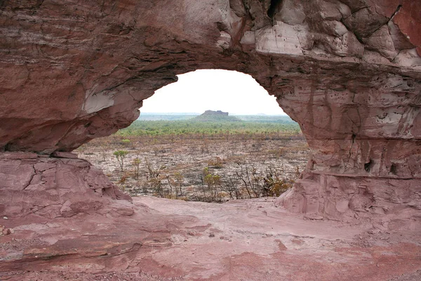
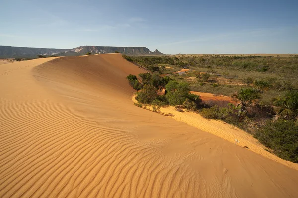
A Natural Arch In Jalapao State Park In The State Of Tocantins, Brazil

Image, 5.56MB, 3456 × 2304 jpg
stock image Jalapao State Park in Tocantins Brazil - Cachoeira da Formiga, near Mateiros City.

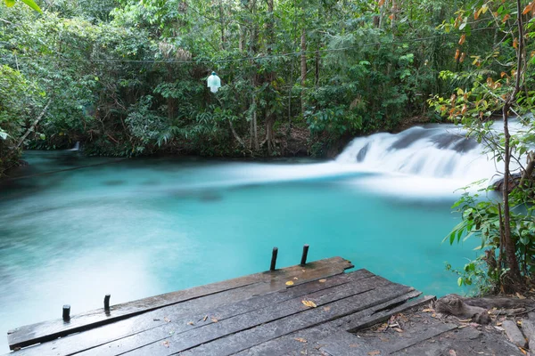
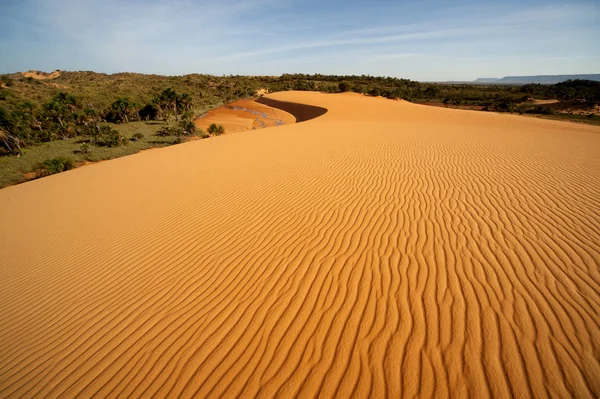
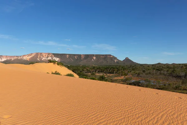
Jalapao State Park In Tocantins Brazil - Cachoeira Da Formiga, Near Mateiros City.

Image, 14.21MB, 5760 × 3840 jpg
stock image Dunes in Jalapo State Park near Mateiros City.

Dunes In Jalapo State Park Near Mateiros City.

Image, 16.15MB, 5760 × 3840 jpg
stock image Sand road in Jalapao State Park, near Mateiros city.

Sand Road In Jalapao State Park, Near Mateiros City.

Image, 10.38MB, 5601 × 3734 jpg
stock vector Brazil States Flag Collection Vector Illustration in Official Colors And Proportion

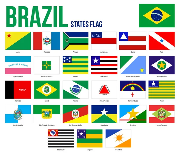
Brazil States Flag Collection Vector Illustration In Official Colors And Proportion

Vector, 2.86MB, 8301 × 7126 eps
stock vector Curved ribbon with fllag of Tocantins is a state of Brazil on white background with copyspace

Curved Ribbon With Fllag Of Tocantins Is A State Of Brazil On White Background With Copyspace

Vector, 3.21MB, 6000 × 3529 eps
stock vector Grunge Tocantins flag

Grunge Tocantins Flag

Vector, 3.64MB, 7031 × 4972 eps
stock image Tocantins State - Brazil

Tocantins State - Brazil

Image, 13.73MB, 8533 × 4500 jpg
stock vector Accurate map of Tocantins

Accurate Map Of Tocantins

Vector, 0.73MB, 4000 × 5000 eps
stock vector Detailed vector map of the mouth of the Amazon River in the Atlantic Ocean, Brazil

Detailed Vector Map Of The Mouth Of The Amazon River In The Atlantic Ocean, Brazil

Vector, 1.94MB, 3719 × 3100 eps
stock vector Coat of arms of the states of Brazil, All Brazilian regions emblem collection

Coat Of Arms Of The States Of Brazil, All Brazilian Regions Emblem Collection

Vector, 18.44MB, 5167 × 4000 eps
stock image Barra de Aroeira, Santa Tereza do Tocantins, Tocantins, Brazil - May 7, 2016: Quilombola woman carrying huge iron pan on her head, crossing asphalt road that goes through quilombo Barra de Aroeira

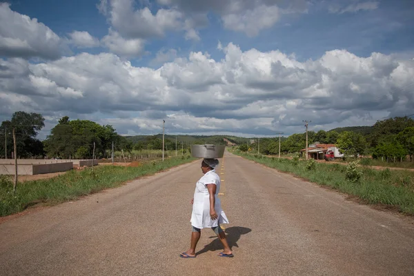
Barra De Aroeira, Santa Tereza Do Tocantins, Tocantins, Brazil - May 7, 2016: Quilombola Woman Carrying Huge Iron Pan On Her Head, Crossing Asphalt Road That Goes Through Quilombo Barra De Aroeira

Image, 20.15MB, 7360 × 4912 jpg
stock image Dunes in Jalapo State Park near Mateiros City.

Dunes In Jalapo State Park Near Mateiros City.

Image, 9.07MB, 5760 × 3840 jpg
stock vector Green Brazil map flag vector silhouette illustration isolated on white background. South America country. Brazil flag.

Green Brazil Map Flag Vector Silhouette Illustration Isolated On White Background. South America Country. Brazil Flag.

Vector, 0.35MB, 5001 × 5001 eps
stock image Long exposure shot of a long, straight, and red sand road leading to a stunning pyramid-shaped mountain covered in green foliage, under blurred storm clouds.

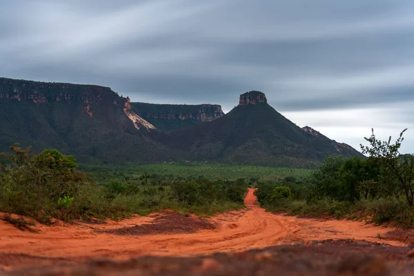
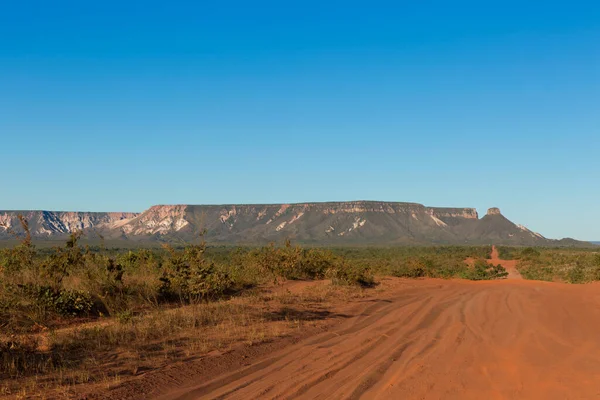
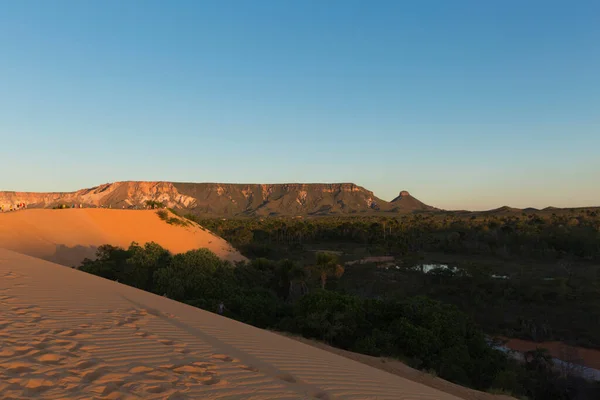
Long Exposure Shot Of A Long, Straight, And Red Sand Road Leading To A Stunning Pyramid-shaped Mountain Covered In Green Foliage, Under Blurred Storm Clouds.

Image, 16.38MB, 7952 × 5304 jpg
stock image  Fervedouro Bela Vista is one of the crystalline water springs that sprout from the sand where tourists can swim in the region of Jalapao, Tocantins

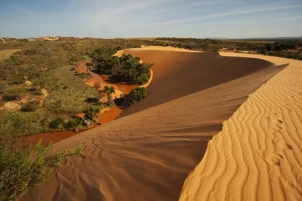
Fervedouro Bela Vista Is One Of The Crystalline Water Springs That Sprout From The Sand Where Tourists Can Swim In The Region Of Jalapao, Tocantins

Image, 14.73MB, 4000 × 6000 jpg
stock image Brazilian rural road at Jalapo desert at Tocantins State

Brazilian Rural Road At Jalapo Desert At Tocantins State

Image, 5.11MB, 3504 × 2336 jpg
stock vector Realistic waving flag of Tocantins, state of Brazil, isolated on white background

Realistic Waving Flag Of Tocantins, State Of Brazil, Isolated On White Background

Vector, 7.8MB, 6000 × 4000 eps
stock vector Symbol Map of the State Tocantins (Brazil) showing the contour of the state/province buffered inside in rainbow colors

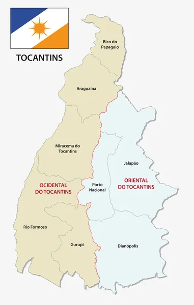
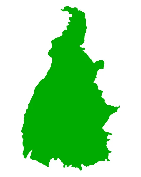
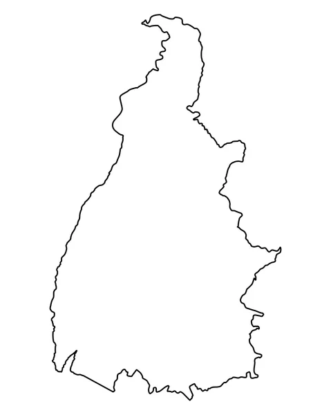
Symbol Map Of The State Tocantins (Brazil) Showing The Contour Of The State/province Buffered Inside In Rainbow Colors

Vector, 1.36MB, 3766 × 6000 eps
stock image Brazil Flag wooden sign

Brazil Flag Wooden Sign

Image, 5.09MB, 4100 × 2662 jpg
stock image Aerial View of Rural Area in Brazil

Aerial View Of Rural Area In Brazil

Image, 11.86MB, 5000 × 3331 jpg
stock image Golden grass Brazilian typical handicraft work from Jalapo

Golden Grass Brazilian Typical Handicraft Work From Jalapo

Image, 3.17MB, 3504 × 2336 jpg
stock image Soybeans

Soybeans

Image, 2.44MB, 5104 × 3371 jpg
stock image Flag of Palmas in Tocantins, Brazil

Flag Of Palmas In Tocantins, Brazil

Image, 2.38MB, 3072 × 1920 jpg
stock image Sand dunes with blue sky in the Tocantins, Brazil

Sand Dunes With Blue Sky In The Tocantins, Brazil

Image, 3.01MB, 4928 × 3264 jpg
stock image Brazil wooden sign

Brazil Wooden Sign

Image, 6.05MB, 4682 × 2843 jpg
stock image Brazilian Jalapo desert at Tocantins State

Brazilian Jalapo Desert At Tocantins State

Image, 5.77MB, 3504 × 2336 jpg
stock image Dunes in Jalapo State Park near Mateiros City.

Dunes In Jalapo State Park Near Mateiros City.

Image, 17.97MB, 5760 × 3840 jpg
stock image Hills in Sao Paulo, Brazil

Hills In Sao Paulo, Brazil

Image, 4.8MB, 3000 × 2153 jpg
stock image 3D illustration of a Sao Paulo flag extended on a flagpole and in the background a beautiful sky with a sunset

3D Illustration Of A Sao Paulo Flag Extended On A Flagpole And In The Background A Beautiful Sky With A Sunset

Image, 4.68MB, 3508 × 2480 jpg
stock image Dunes in Jalapo State Park near Mateiros City.

Dunes In Jalapo State Park Near Mateiros City.

Image, 11.75MB, 5690 × 3793 jpg
Previous << Page 2 >> Next