Home
Images
Vectors
Videos
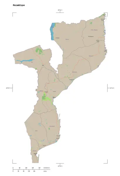
Stock image Shape of a topographic, OSM standard style map of the Mozambique, with distance scale and map border coordinates, isolated on white
Published:
Dec.28, 2023 13:27:57
Author:
zelwanka
Views:
0
Downloads:
0
File type:
image
/
jpg
File size:
0.78 MB
Orginal size:
1755
x
2564
px
Available sizes:
S
(342 x 500)
M
(684 x 1000)
L
(1369 x 2000)
XL
(1755 x 2564)
EL0
(1755 x 2564)
Level:
beginner
Download Image
Image topics:
White
Solid
Isolated
Shape
Nature
Standard
Border
Contour
Earth
Planet
World
Ocean
Science
Capital
Outline
Country
Map
Geography
Africa
Continent
Land
Zoom
Region
Territory
Atlas
Legend
Coordinates
Mozambique
Maputo
Stereographic
OSM
Distance Scale
Moz
Administrative Division
Openstreet
Similar stock images
Shape Of Nkhata Bay, District Of Malawi, With Its Capital Isolated On White Background. Colored Elevation Map. 3D Rendering
3473 × 3836
Shape Of Mashonaland West, Province Of Zimbabwe, With Its Capital Isolated On White Background. Topographic Relief Map. 3D Rendering
3356 × 3836
Folkestone And Hythe, Non Metropolitan District Of England - Great Britain. Grayscale Elevation Map With Lakes And Rivers. Locations And Names Of Major Cities Of The Region. Corner Auxiliary Location Maps
4930 × 3770
Shape Of Taraba, State Of Nigeria, With Its Capital Isolated On White Background. Topographic Relief Map. 3D Rendering
3597 × 3836
Shape Of West Pomeranian, Voivodeship Of Poland, With Its Capital Isolated On White Background. Topographic Relief Map. 3D Rendering
3628 × 3836
Shape Of Yasothon, Province Of Thailand, With Its Capital Isolated On White Background. Bilevel Elevation Map. 3D Rendering
2936 × 3836
Shape Of Panama Oeste, Province Of Panama, With Its Capital Isolated On White Background. Topographic Relief Map. 3D Rendering
3231 × 3836
Shape Of Paraguay With Its Capital Isolated On A Solid Color Background. Colored Elevation Map. 3D Rendering
2031 × 2175