Home
Images
Vectors
Videos
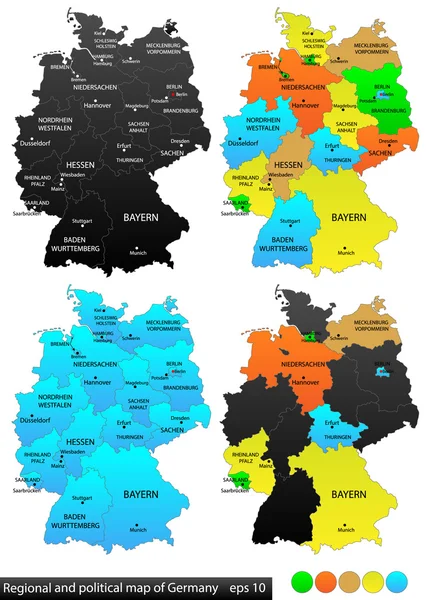
Stock vector Germany political map divide by state colorful outline simplicity style.
Published:
Oct.28, 2020 14:21:43
Author:
tanarch
Views:
0
Downloads:
0
File type:
vector
/
eps
File size:
5.76 MB
Orginal size:
3876
x
5791
px
Available sizes:
S
(335 x 500)
M
(669 x 1000)
L
(1339 x 2000)
XL
(3876 x 5791)
VECT
(3876 x 5791)
EL0
(3876 x 5791)
Level:
bronze
Download Vector
Vector topics:
White
Vector
Background
Graphic
Illustration
Isolated
Shape
Travel
European
Silhouette
Border
Symbol
Concept
Digital
Contour
Tourism
Capital
Europe
Outline
Country
German
Map
Cartography
Geography
National
Germany
Worldwide
State
Political
Administrative
Geographic
Republic
States
Berlin
Region
Federal
Bavaria
Nation
Munich
Bremen
Hamburg
Saxony
Infographic
Similar stock vectors
Germany Political Map Divide By State Colorful Outline Simplicity Style.
3876 × 5791
Maps Of Germany, Federal States And Berlin With Boroughs
3589 × 4041
Germany Political Map Divide By State Colorful Outline Simplicity Style.
8073 × 12065
Political And Location Map Of Germany. Versatile File, Every Piece Is Selectable And Editable In Layers Panel. Turn On And Off Visibility Of Every Province In One Click. Vector, Eps 10.
3840 × 5400
Simple Graphic Vector Illustration
2480 × 2480
Germany Map Divided On West And East Germany Map, Administrative Division Separates Regions And Names, Design Card Blackboard Chalkboard Vector
5174 × 4000
Maps Of Germany
4439 × 5000
Germany High Detailed Vector Map (colored By States And Administrative Districts) With Subdivisions. All Layers Detachable And Labeled.
5801 × 7292