Home
Images
Vectors
Videos
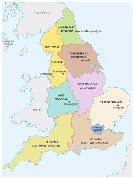
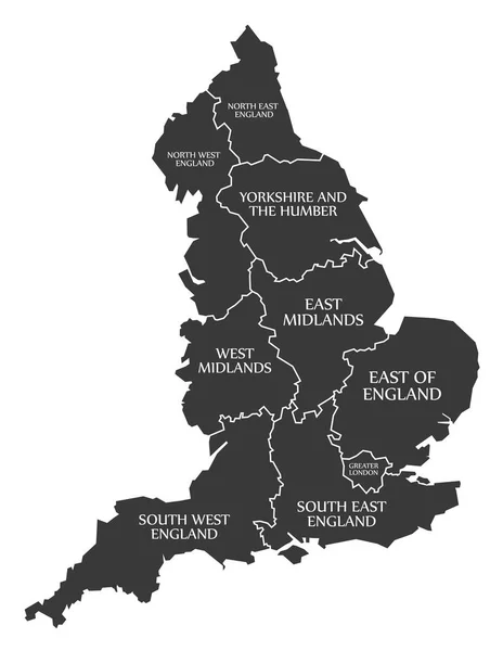
Stock vector Map England. Poster map of regions of England. Black and white print map of England for t-shirt, poster, print. Hand-drawn graphic map with regions. Vector Illustration
Published:
Apr.24, 2020 07:29:33
Author:
FoxysGraphic
Views:
5
Downloads:
0
File type:
vector
/
eps
File size:
2.53 MB
Orginal size:
5305
x
6000
px
Available sizes:
S
(442 x 500)
M
(884 x 1000)
L
(1768 x 2000)
XL
(5305 x 6000)
VECT
(5305 x 6000)
EL0
(5305 x 6000)
Level:
silver
Download Vector
Vector topics:
White
Vector
Background
Graphic
Illustration
Design
Business
Sign
Black
Silhouette
Border
Retro
Vintage
Icon
Text
Contour
Drawing
World
Europe
Print
Country
Map
Ireland
Land
Uk
Letters
State
Poster
Symbols
Great
Island
Political
Union
United
Kingdom
Britain
London
Region
English
British
Territory
England
Typography
Atlas
Wales
Scotland
United Kingdom
Northern Ireland
Map Vector
Similar stock vectors
Map England. Poster Map Of Regions Of England. Black And White Print Map Of England For T-shirt, Poster, Print. Hand-drawn Graphic Map With Regions. Vector Illustration
5263 × 6000
Outline Map Of The Nine Regions Of England
3100 × 4130
Colorful Map Of England With Outline On White Background
4167 × 4167
United Kingdom Physical Map
3812 × 5671
United Kingdom Map Vector - Major Cities Marked On Map Of The UK.
3902 × 5496
Modern Map - England With Counties UK
4700 × 5453
England Map Labelled Black
5000 × 6463