Home
Images
Vectors
Videos
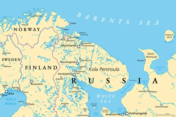
Stock vector Murmansk Oblast and Kola Peninsula, political map. Federal subject of Russia, part of Lapland region, bordering Norway and Finland. With Murmansk, most important port city of Russia on Arctic Ocean.
Published:
Jun.17, 2022 10:18:21
Author:
Furian
Views:
484
Downloads:
0
File type:
vector
/
eps
File size:
8.21 MB
Orginal size:
9000
x
6000
px
Available sizes:
S
(500 x 333)
M
(1000 x 667)
L
(2000 x 1333)
XL
(9000 x 6000)
VECT
(9000 x 6000)
EL0
(9000 x 6000)
Level:
silver
Download Vector
Vector topics:
Vector
Illustration
Travel
Border
City
Harbor
North
Europe
Russia
Country
Map
Cartography
Geography
Russian
Land
Overview
Port
Boundary
Arkhangelsk
Political
Arctic
Polar
Finland
Region
Murmansk
Federal
Subject
Atlas
Norway
Peninsula
Nation
Mapping
Finnmark
Lapland
Kola
Oblast
Troms
Infographic
Port City
White Sea
Kandalaksha
Arctic Ocean
Barents Sea
Kola Peninsula
Federal Subject
Sapmi
Political Map
Murmansk Oblast
Lapland Region
Kanin Peninsula
Similar stock vectors
Saint Petersburg Area, Political Map. Second-largest City In Russia, Formerly Known As Petrograd And Later Leningrad. Situated On The Neva River, At The Head Of The Gulf Of Finland On The Baltic Sea.
9000 × 5999
Russia - Highly Detailed Editable Political Map With Labeling.
5771 × 3561
High Detailed Russia Physical Map With Labeling.
5771 × 3561
Highly Detailed Editable Political Map With Separated Layers. Russia.
5771 × 3561
Sea Of Okhotsk, Gray Political Map. Marginal Sea Of The North Pacific Ocean Located Between The Kamchatka Peninsula, The Kuril Islands, Hokkaido, Sakhalin, And A Stretch Of The Eastern Siberian Coast.
6000 × 6000
Saint Petersburg Area, Gray Political Map. Second-largest City In Russia, Formerly Known As Petrograd And Later Leningrad. Situated On The Neva River, At The Head Of Gulf Of Finland In The Baltic Sea.
9000 × 6000
High Detailed Finland Road Map With Labeling.
3910 × 7091