Home
Images
Vectors
Videos
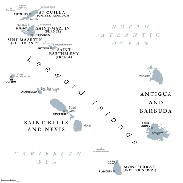
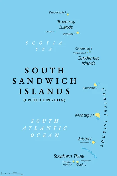
Stock vector South Sandwich Islands, gray political map. Part of the British Overseas Territory South Georgia and the South Sandwich Islands. Group of islands in the South Atlantic Ocean and Scotia Sea. Vector
Published:
Sep.20, 2024 05:22:17
Author:
Furian
Views:
0
Downloads:
0
File type:
vector
/
eps
File size:
2.29 MB
Orginal size:
6000
x
8460
px
Available sizes:
S
(355 x 500)
M
(709 x 1000)
L
(1418 x 2000)
XL
(6000 x 8460)
VECT
(6000 x 8460)
EL0
(6000 x 8460)
Level:
silver
Download Vector
Vector topics:
Group
Vector
Illustration
Isolated
Gray
South
Arc
Map
Cartography
Geography
Land
Uk
Overview
Silhouettes
Sandwich
Island
Antarctic
Atlantic
Overseas
Islands
Southern
British
Possession
Territory
Atlas
Volcanic
Mapping
Bristol
Vindication
United Kingdom
Atlantic Ocean
Thule
Cook Island
Crown Colony
Montagu
South Sandwich Islands
Political Map
Saunders
South Atlantic
Scotia Sea
Zavodovski
Central Islands
Visokoi
Thule Island
Southern Thule
Candlemas Islands
Traversay Islands
Morrell Island
Similar stock vectors
From Anguilla To Montserrat, Gray Political Map. Caribbean Islands, Part Of Leeward Islands And Lesser Antilles. Anguilla, Saint Martin, Saint Kitts And Nevis, Antigua And Barbuda, And Montserrat.
6000 × 6000
South Sandwich Islands, Political Map. Part Of The British Overseas Territory Of South Georgia And The South Sandwich Islands. Group Of Islands In The South Atlantic Ocean And Scotia Sea. Vector.
6000 × 9000
Guernsey And Jersey, Channel Islands, Gray Political Map
6489 × 9733
Map Of The Dutch Saba Bank National Park In The Caribbean Sea
3764 × 3100
Mascarene Islands, Gray Map, Mauritius, Reunion, Rodrigues
9999 × 5905
Cayman Islands Highly Detailed Physical Map
7500 × 4465
Saint Kitts, Nevis, Antigua, Barbuda, Montserrat Political Map
9566 × 6604
Iceland - Vintage Map And Flag - Detailed Vector Illustration
6389 × 5500