photo free
Home Images Vectors Videos

Stock image Lincoln Silhouette Map

stock vector Nebraska outline map set

Nebraska Outline Map Set

Vector, 0.27MB, 5079 × 3736 eps
stock vector Lincoln department (Buenos Aires) outline map set

Lincoln Department (Buenos Aires) Outline Map Set

Vector, 0.23MB, 6000 × 3000 eps
stock vector American-style character with a beard, glasses, mustache and glasses. logo on a white background

American-style Character With A Beard, Glasses, Mustache And Glasses. Logo On A White Background

Vector, 3.07MB, 5000 × 5000 eps
stock vector American-style character with a beard, glasses, mustache and glasses. logo on a white background

American-style Character With A Beard, Glasses, Mustache And Glasses. Logo On A White Background

Vector, 3.07MB, 5000 × 5000 eps
stock vector United States of America isolated map and Nebraska State territory. vector USA political map. geographic banner template

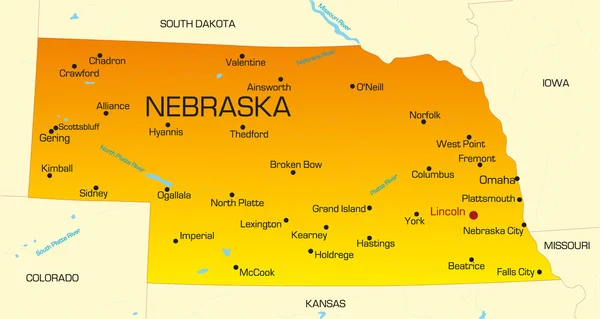
United States Of America Isolated Map And Nebraska State Territory. Vector USA Political Map. Geographic Banner Template

Vector, 0.76MB, 6000 × 4000 eps
stock vector Nebraska line art map

Nebraska Line Art Map

Vector, 2.48MB, 5000 × 5000 eps
stock vector Nebraska map

Nebraska Map

Vector, 7.44MB, 7002 × 7002 eps
stock vector The black and white Louisiana State County Maps

The Black And White Louisiana State County Maps

Vector, 8.32MB, 3504 × 6204 eps
stock vector The Louisiana State County Map with labels

The Louisiana State County Map With Labels

Vector, 9.49MB, 5000 × 4600 eps
stock vector The Missouri State county map with labels

The Missouri State County Map With Labels

Vector, 9.94MB, 5000 × 5000 eps
stock vector The black and white Maine State County Maps

The Black And White Maine State County Maps

Vector, 8.39MB, 5000 × 3500 eps
stock vector Nebraska

Nebraska

Vector, 0.82MB, 6692 × 3566 eps
stock vector The Nebraska State County Map with labels

The Nebraska State County Map With Labels

Vector, 9.48MB, 5000 × 3000 eps
stock vector Highly detailed vector silhouettes of US state maps, Division United States into counties, political and geographic subdivisions of a states, West North Central - North Dakota, South Dakota, Nebraska - set 7 of 17

Highly Detailed Vector Silhouettes Of US State Maps, Division United States Into Counties, Political And Geographic Subdivisions Of A States, West North Central - North Dakota, South Dakota, Nebraska - Set 7 Of 17

Vector, 6.36MB, 9608 × 4501 eps
stock vector 37 of 50 states of the United States with a name, nickname, and

37 Of 50 States Of The United States With A Name, Nickname, And

Vector, 0.74MB, 7311 × 4112 eps
stock vector Iowa

Iowa

Vector, 0.79MB, 4981 × 3672 eps
stock vector 2017 Solar Eclipse Geometry Across Nebraska Cities Map vector Illustration

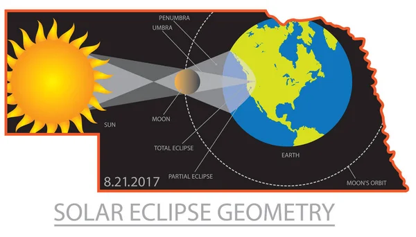
2017 Solar Eclipse Geometry Across Nebraska Cities Map Vector Illustration

Vector, 1.32MB, 6707 × 3825 eps
stock vector 2017 Solar Eclipse Geometry Across Oregon Cities Map vector Illustration

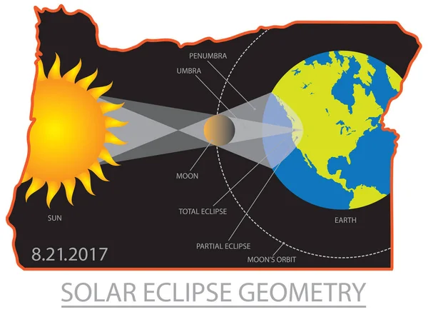
2017 Solar Eclipse Geometry Across Oregon Cities Map Vector Illustration

Vector, 1.51MB, 5759 × 4200 eps
stock vector Greatest American Symbols

Greatest American Symbols

Vector, 5.51MB, 4528 × 5000 eps
stock vector Nebraska, state of USA - white vector 3D map of country area.

Nebraska, State Of USA - White Vector 3D Map Of Country Area.

Vector, 1.82MB, 8000 × 8000 eps
stock vector Map US capital city Washington with district

Map US Capital City Washington With District

Vector, 5.56MB, 5400 × 3600 eps
stock vector Nebraska. Collection of four vector hearts with flag. Heart silhouette

Nebraska. Collection Of Four Vector Hearts With Flag. Heart Silhouette

Vector, 8.1MB, 5000 × 5000 eps
stock vector Grey map of Nebraska

Grey Map Of Nebraska

Vector, 1.32MB, 5000 × 3240 eps
stock image Map Of Nebraska 3d Shape

Map Of Nebraska 3d Shape

Image, 2.35MB, 5600 × 4200 jpg
stock vector 2017 Solar Eclipse Across Oregon Cities Map vector Illustration

2017 Solar Eclipse Across Oregon Cities Map Vector Illustration

Vector, 1.26MB, 6138 × 3930 eps
stock image Nebraska Map 3d Shape

Nebraska Map 3d Shape

Image, 4.62MB, 5600 × 4200 jpg
stock image State of Nebraska map

State Of Nebraska Map

Image, 0.84MB, 4300 × 2800 jpg
stock vector Set of Nebraska map, united states of america. Flat concept icon vector illustration .

Set Of Nebraska Map, United States Of America. Flat Concept Icon Vector Illustration .

Vector, 0.2MB, 4096 × 4096 eps
stock vector Stamp of Nebraska cities

Stamp Of Nebraska Cities

Vector, 2.57MB, 5039 × 5039 eps
stock vector blue abstract map of Nebraska

Blue Abstract Map Of Nebraska

Vector, 1.35MB, 4800 × 3360 eps
stock vector Nebraska, state of USA - solid black outline map of country area. Simple flat vector illustration

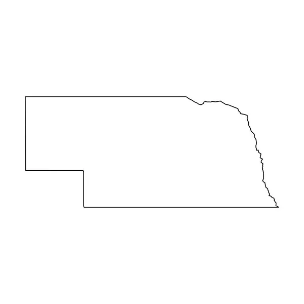
Nebraska, State Of USA - Solid Black Outline Map Of Country Area. Simple Flat Vector Illustration

Vector, 0.22MB, 5000 × 5000 eps
stock vector Nebraska USA state map vector tag cloud illustration

Nebraska USA State Map Vector Tag Cloud Illustration

Vector, 8.87MB, 13583 × 5914 eps
stock image Map of New Jersey

Map Of New Jersey

Image, 4.98MB, 4000 × 4000 jpg
stock image Map of Maryland

Map Of Maryland

Image, 3.44MB, 4000 × 2620 jpg
stock vector Nebraska, Lincoln stamp

Nebraska, Lincoln Stamp

Vector, 1.07MB, 5039 × 5030 eps
stock vector Illinois stamp

Illinois Stamp

Vector, 3.49MB, 5000 × 5000 eps
stock vector Nebraska. Vector silhouette state. Nebraska map with text script. Nebraska shape state map for poster, t-shirt, tee, souvenir. Vector outline Isolated illustratuon on a white background.

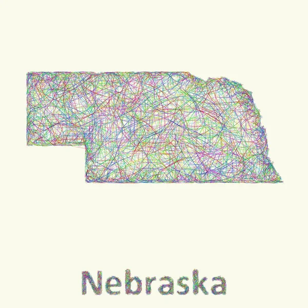
Nebraska. Vector Silhouette State. Nebraska Map With Text Script. Nebraska Shape State Map For Poster, T-shirt, Tee, Souvenir. Vector Outline Isolated Illustratuon On A White Background.

Vector, 0.37MB, 8000 × 3963 eps
stock vector Nebraska map shape, united states of america. Flat concept icon symbol vector illustration .

Nebraska Map Shape, United States Of America. Flat Concept Icon Symbol Vector Illustration .

Vector, 0.25MB, 4096 × 4096 eps
stock vector Illinois, U.S. state subdivided into 102 counties, gray political map with borders and county names. State in the Midwestern region of USA. Land of Lincoln, Prairie State, and The Inland Empire State.

Illinois, U.S. State Subdivided Into 102 Counties, Gray Political Map With Borders And County Names. State In The Midwestern Region Of USA. Land Of Lincoln, Prairie State, And The Inland Empire State.

Vector, 1.88MB, 5390 × 9000 eps
stock vector Nebraska, U.S. state, subdivided into 93 counties, gray political map with borders and county names. Triply landlocked state in the Midwestern region of United States, nicknamed The Cornhusker State.

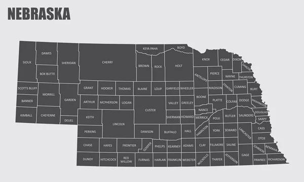
Nebraska, U.S. State, Subdivided Into 93 Counties, Gray Political Map With Borders And County Names. Triply Landlocked State In The Midwestern Region Of United States, Nicknamed The Cornhusker State.

Vector, 1.66MB, 9000 × 4645 eps
stock image Map of Lincoln County in New Mexico state on white background. single County map highlighted by black color on New Mexico map. UNITED STATES, US

Map Of Lincoln County In New Mexico State On White Background. Single County Map Highlighted By Black Color On New Mexico Map. UNITED STATES, US

Image, 3.3MB, 8000 × 5334 jpg
stock vector Official current vector great seal of the Federal State of Nebraska, USA

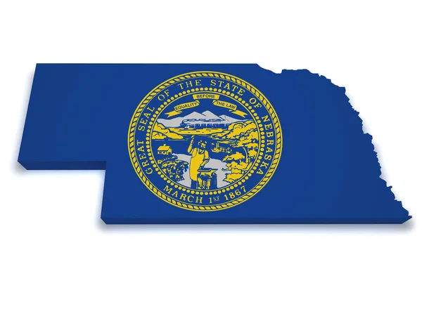
Official Current Vector Great Seal Of The Federal State Of Nebraska, USA

Vector, 1.38MB, 4900 × 4900 eps
stock image Map of Lincoln County in Georgia state on white background. single County map highlighted by black colour on Georgia map. UNITED STATES, US

Map Of Lincoln County In Georgia State On White Background. Single County Map Highlighted By Black Colour On Georgia Map. UNITED STATES, US

Image, 6.6MB, 8000 × 8000 jpg
stock image A Nebraska State Flag Map Illustration with clipping path

A Nebraska State Flag Map Illustration With Clipping Path

Image, 4.56MB, 7000 × 7000 jpg
stock vector Nebraska, Lincoln stamp

Nebraska, Lincoln Stamp

Vector, 0.65MB, 4583 × 4580 eps
stock image Map of Lincoln County in Colorado state on white background. single County map highlighted by black colour on Colorado map. UNITED STATES, US

Map Of Lincoln County In Colorado State On White Background. Single County Map Highlighted By Black Colour On Colorado Map. UNITED STATES, US

Image, 4.35MB, 8000 × 6266 jpg
stock vector Port Lincoln (South Australia) outline map set

Port Lincoln (South Australia) Outline Map Set

Vector, 0.34MB, 6000 × 3000 eps
stock vector Nebraska, U.S. state, subdivided into 93 counties,multi colored political map with capital Lincoln, borders and county names.State in the Midwestern region of the United States. The Cornhusker State.

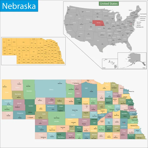
Nebraska, U.S. State, Subdivided Into 93 Counties,multi Colored Political Map With Capital Lincoln, Borders And County Names.State In The Midwestern Region Of The United States. The Cornhusker State.

Vector, 1.68MB, 9000 × 4645 eps
stock vector The black and white administrative maps of Idaho State, USA

The Black And White Administrative Maps Of Idaho State, USA

Vector, 8.21MB, 6004 × 4428 eps
stock vector nebraska state with beautiful view

Nebraska State With Beautiful View

Vector, 0.07MB, 4009 × 2011 eps
Page 1 >> Next