
Stock image Northwest Division

NEW YORK, USA, JUN 18, 2020: Oklahoma City Thunder Logo Of Professional Basketball Club In American League. Silhouette Of Basket Player In Foreground. Sport Concept Photo, Edit Space.
Image, 18.83MB, 5926 × 3943 jpg

NEW YORK, USA, JUN 18, 2020: Portland Trail Blazers Logo Of Professional Basketball Club In American League. Silhouette Of Basket Player In Foreground. Sport Concept Photo, Edit Space.
Image, 20.26MB, 5926 × 3943 jpg

NEW YORK, USA, JUN 18, 2020: Utah Jazz Logo Of Professional Basketball Club In American League. Silhouette Of Basket Player In Foreground. Sport Concept Photo, Edit Space.
Image, 18.92MB, 5926 × 3943 jpg

NEW YORK, USA, JUN 18, 2020: Denver Nuggets Basketball Club Logo, Silhouette Of Jumping Basket Player, Sport Photo NBA, Edit Space.
Image, 8.13MB, 5653 × 3761 jpg

NEW YORK, USA, JUN 18, 2020: Portland Trail Blazers Basketball Club On The White Screen. Silhouette Of NBA Trophy In Foreground.
Image, 14.91MB, 5934 × 3948 jpg

NEW YORK, USA, JUN 18, 2020: Denver Nuggets Logo Of Professional Basketball Club In American League. Silhouette Of Basket Player In Foreground. Sport Concept Photo, Edit Space.
Image, 18.4MB, 5926 × 3943 jpg

NEW YORK, USA, JUN 18, 2020: Utah Jazz Basketball Club On The White Screen. Silhouette Of NBA Trophy In Foreground.
Image, 14.11MB, 5934 × 3948 jpg

NEW YORK, USA, JUN 18, 2020: Oklahoma City Thunder Basketball Club On The White Screen. Silhouette Of NBA Trophy In Foreground.
Image, 14.37MB, 5934 × 3948 jpg

NEW YORK, USA, JUN 18, 2020: Denver Nuggets Basketball Club On The White Screen. Silhouette Of NBA Trophy In Foreground.
Image, 14.76MB, 5934 × 3948 jpg

MIAMI, USA, MAY 31, 2023: Glimpses Of Greatness: Denver Nuggets Vs Miami Heat Clash In The NBA Finals, With The Iconic Larry O'Brien Championship Trophy As A Silhouette
Image, 14.53MB, 5711 × 3800 jpg

DENVER, USA, MAY 31, 2023: NBA Finals Showdown: Denver Nuggets Vs Miami Heat, Embodied By The Majestic Silhouette Of The Larry O'Brien Championship Trophy
Image, 4.06MB, 5860 × 3899 jpg


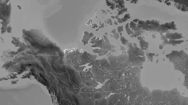
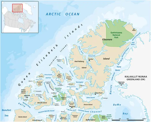
Northwest Territories, Territory Of Canada. Grayscaled Map With Lakes And Rivers. Shape Outlined Against Its Country Area. 3D Rendering
Image, 2.1MB, 2880 × 1620 jpg


NEW YORK, USA, JUN 18, 2020: Minnesota Timberwolves Basketball Club On The White Screen. Silhouette Of NBA Trophy In Foreground.
Image, 14.65MB, 5934 × 3948 jpg
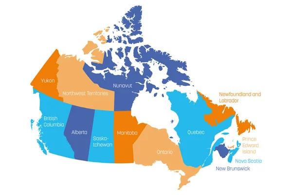
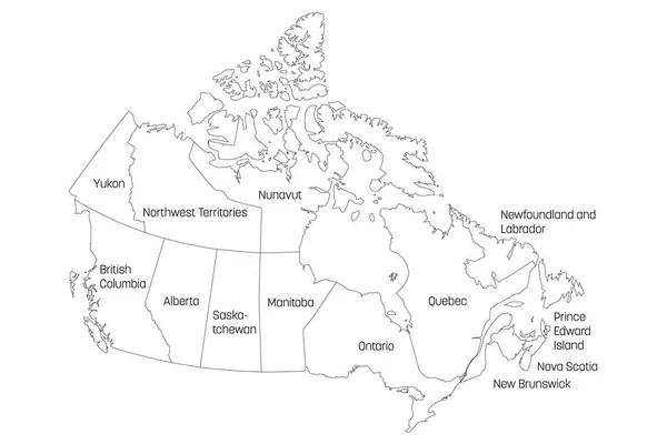
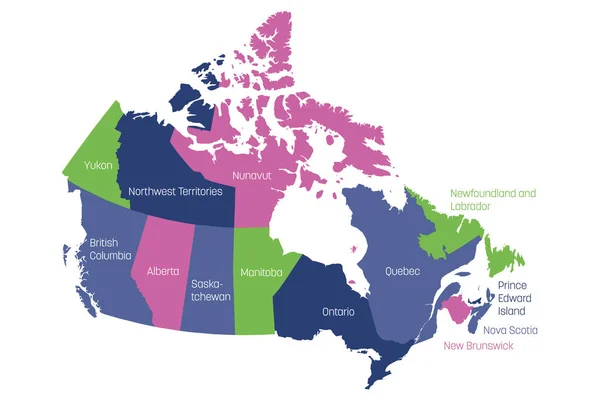
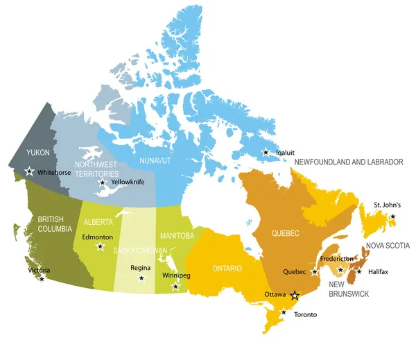
Map Of Canada Divided Into 10 Provinces And 3 Territories. Administrative Regions Of Canada. Multicolored Map With Labels. Vector Illustration
Vector, 1.2MB, 6000 × 4000 eps
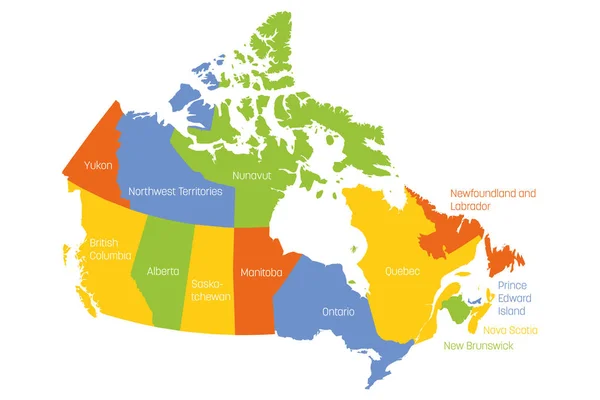
Map Of Canada Divided Into 10 Provinces And 3 Territories. Administrative Regions Of Canada. Multicolored Map With Labels. Vector Illustration
Vector, 1.2MB, 6000 × 4000 eps
Map Of Canada Divided Into 10 Provinces And 3 Territories. Administrative Regions Of Canada. White Map With Black Outline And Black Region Name Labels. Vector Illustration
Vector, 1.84MB, 6000 × 4000 eps
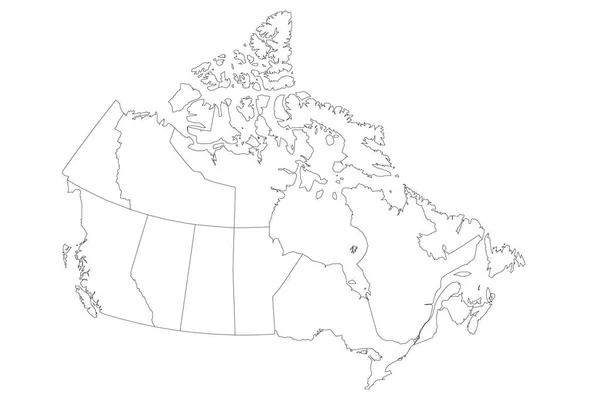
Map Of Canada Divided Into 10 Provinces And 3 Territories. Administrative Regions Of Canada. Blank White Map With Black Outline. Vector Illustration
Vector, 1.74MB, 6000 × 4000 eps
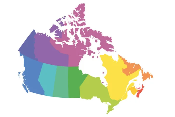
Map Of Canada Divided Into 10 Provinces And 3 Territories. Administrative Regions Of Canada. Blank Multicolored Map. Vector Illustration
Vector, 1.11MB, 6000 × 4000 eps


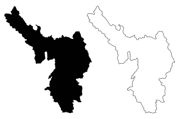
Lai Chau Province (Socialist Republic Of Vietnam, Subdivisions Of Vietnam) Map Vector Illustration, Scribble Sketch Tinh Lai Chau Map
Vector, 0.59MB, 7087 × 4726 eps

Washington, U.S. State, Subdivided Into 39 Counties, Political Map With Borders And County Names. Westernmost State In The Pacific Northwest Region Of The United States, Nicknamed The Evergreen State.
Vector, 3.11MB, 9000 × 5923 eps

Hoa Binh Province (Socialist Republic Of Vietnam, Subdivisions Of Vietnam) Map Vector Illustration, Scribble Sketch Tinh Hoa Binh Map
Vector, 0.63MB, 7087 × 4726 eps

Northwest Territories Region Location Within Canada 3d Isometric Map
Vector, 2.56MB, 4000 × 4000 eps


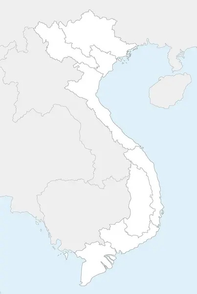
Vector Illustrated Blank Map Of Vietnam With Regions And Administrative Divisions, And Neighbouring Countries And Territories. Editable And Clearly Labeled Layers.
Vector, 2.92MB, 3500 × 5200 eps

Vector Blank Map Of Vietnam With Regions Or Territories And Administrative Divisions. Editable And Clearly Labeled Layers.
Vector, 1.76MB, 3500 × 5200 eps
Dien Bien Province (Socialist Republic Of Vietnam, Subdivisions Of Vietnam) Map Vector Illustration, Scribble Sketch Tinh Dien Bien Map
Vector, 0.61MB, 7087 × 4726 eps

Vector Illustrated Map Of Vietnam With Regions And Administrative Divisions, And Neighbouring Countries And Territories. Editable And Clearly Labeled Layers.
Vector, 3.41MB, 3500 × 5200 eps
Map Of Canada Divided Into 10 Provinces And 3 Territories. Administrative Regions Of Canada. Multicolored Map With Labels. Vector Illustration
Vector, 1.2MB, 6000 × 4000 eps

Detailed Washington State Map, Highly Detailed Territory And Road Plan, Vector Illustration
Vector, 5.31MB, 7043 × 5292 eps

Vector Map Of Vietnam With Regions Or Territories And Administrative Divisions. Editable And Clearly Labeled Layers.
Vector, 1.83MB, 3500 × 5200 eps
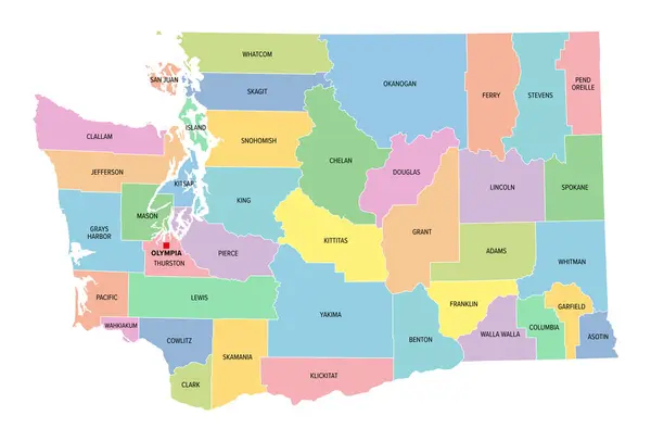
Washington, U.S. State, Multi Colored Political Map With Borders, County Names And Capital Olympia. Westernmost State In The Pacific Northwest Region Of The United States, Subdivided Into 39 Counties.
Vector, 2.14MB, 8857 × 6000 eps

The Detailed Map Of Iceland With Regions Or States. Administrative Division
Vector, 0.52MB, 7000 × 5000 eps

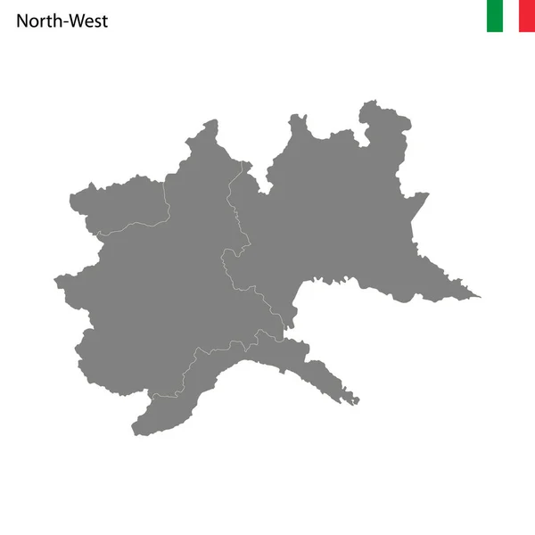
High Quality Map Northwest Region Of Italy, With Borders Of The Provinces
Vector, 0.99MB, 4000 × 4000 eps
Son La Province (Socialist Republic Of Vietnam, Subdivisions Of Vietnam) Map Vector Illustration, Scribble Sketch Tinh Son La Map
Vector, 0.63MB, 7087 × 4726 eps

Vector Map Of Vietnam With Regions And Administrative Divisions, And Neighbouring Countries And Territories. Editable And Clearly Labeled Layers.
Vector, 2.72MB, 3500 × 5200 eps

Washington, U.S. State Subdivided Into 39 Counties, Gray Political Map With Borders And County Names. Westernmost State In The Pacific Northwest Region Of The United States, Nicknamed Evergreen State.
Vector, 2.12MB, 8857 × 6000 eps

Vector Blank Map Of Vietnam With Regions Or Territories And Administrative Divisions. Editable And Clearly Labeled Layers.
Vector, 1.76MB, 3500 × 5200 eps
Vector Blank Map Of Vietnam With Regions And Administrative Divisions, And Neighbouring Countries And Territories. Editable And Clearly Labeled Layers.
Vector, 2.56MB, 3500 × 5200 eps

Vector Map Of Vietnam With Regions Or Territories And Administrative Divisions. Editable And Clearly Labeled Layers.
Vector, 1.83MB, 3500 × 5200 eps

Oregon Counties, Gray Political Map With Borders And County Names. State In The Pacific Northwest Region Of The United States, Subdivided Into 36 Counties. Nicknamed The Beaver State. Illustration.
Vector, 2.19MB, 7830 × 6000 eps

Oregon Counties, Political Map With Borders And County Names. State In The Pacific Northwest Region Of The United States, Subdivided Into 36 Counties. Nicknamed The Beaver State. Illustration. Vector
Vector, 2.81MB, 7870 × 6000 eps
Page 1 >> Next