photo free
Home Images Vectors Videos

Stock image Agrihan Island

stock image Agrihan Island in the Philippine Sea - belonging to United States. Described location diagram with yellow shape of the island and sample maps of its surroundings

Agrihan Island In The Philippine Sea - Belonging To United States. Described Location Diagram With Yellow Shape Of The Island And Sample Maps Of Its Surroundings

Image, 2.03MB, 3840 × 2160 jpg
stock image Shape of Agrihan Island in the Philippine Sea, belonging to United States

Shape Of Agrihan Island In The Philippine Sea, Belonging To United States

Image, 0.23MB, 2160 × 2160 jpg
stock image Agrihan Island in the Philippine Sea on a colored elevation map

Agrihan Island In The Philippine Sea On A Colored Elevation Map

Image, 0.79MB, 2880 × 1620 jpg
stock image Agrihan Island in the Philippine Sea, belonging to United States, isolated on a topographic, OSM Humanitarian style map, with distance scale

Agrihan Island In The Philippine Sea, Belonging To United States, Isolated On A Topographic, OSM Humanitarian Style Map, With Distance Scale

Image, 0.68MB, 2160 × 2160 jpg
stock image Agrihan Island in the Philippine Sea, belonging to United States, isolated on a satellite image taken in March 20, 2024, with distance scale

Agrihan Island In The Philippine Sea, Belonging To United States, Isolated On A Satellite Image Taken In March 20, 2024, With Distance Scale

Image, 1.88MB, 2160 × 2160 jpg
stock image Agrihan Island in the Philippine Sea, belonging to United States, isolated on a bilevel elevation map, with distance scale

Agrihan Island In The Philippine Sea, Belonging To United States, Isolated On A Bilevel Elevation Map, With Distance Scale

Image, 0.39MB, 2160 × 2160 jpg
stock image Agrihan Island in the Philippine Sea on a satellite image taken in March 20, 2024

Agrihan Island In The Philippine Sea On A Satellite Image Taken In March 20, 2024

Image, 5.23MB, 2880 × 1620 jpg
stock image Agrihan Island in the Philippine Sea on a topographic, OSM Humanitarian style map

Agrihan Island In The Philippine Sea On A Topographic, OSM Humanitarian Style Map

Image, 0.51MB, 2880 × 1620 jpg
stock image Agrihan Island in the Philippine Sea on a bilevel elevation map

Agrihan Island In The Philippine Sea On A Bilevel Elevation Map

Image, 0.31MB, 2880 × 1620 jpg
stock vector Northern Mariana Islands political map

Northern Mariana Islands Political Map

Vector, 2.47MB, 6974 × 8999 eps
stock vector Guam and Northern Mariana Islands, political map. Two separate unincorporated territories of the United States of America in the Micronesia subregion of the Western Pacific Ocean. Illustration. Vector

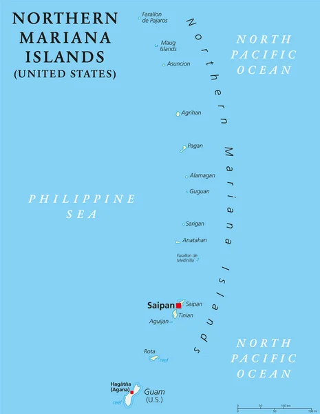
Guam And Northern Mariana Islands, Political Map. Two Separate Unincorporated Territories Of The United States Of America In The Micronesia Subregion Of The Western Pacific Ocean. Illustration. Vector

Vector, 3.12MB, 6000 × 6000 eps
stock vector Guam and Northern Mariana Islands, gray political map. Two separate unincorporated territories of the United States of America in the Micronesia subregion of the Western Pacific Ocean. Illustration.

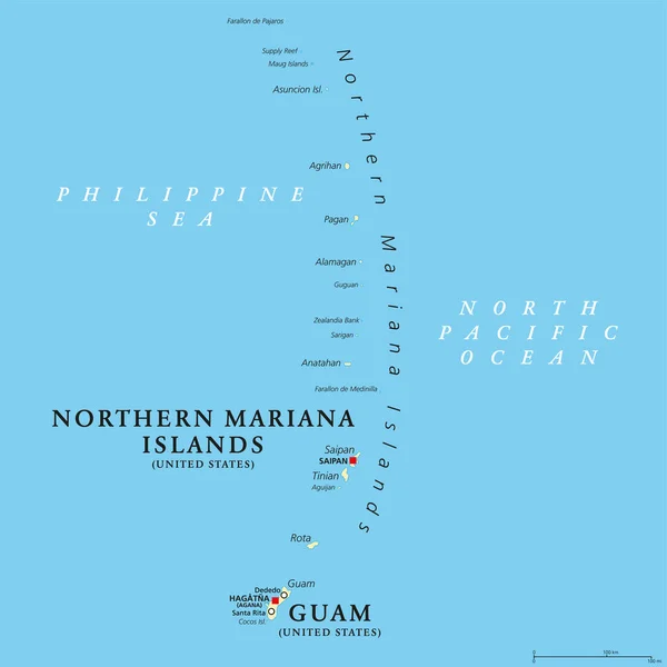
Guam And Northern Mariana Islands, Gray Political Map. Two Separate Unincorporated Territories Of The United States Of America In The Micronesia Subregion Of The Western Pacific Ocean. Illustration.

Vector, 2.02MB, 6000 × 8996 eps
Page 1 >> Next