photo free
Home Images Vectors Videos

Stock image Graticule

stock image Globe globe

Globe Globe

Image, 6.88MB, 7340 × 3670 jpg
stock image Peru area on the satellite C map in the stereographic projection - raw composition of raster layers with dark glowing outline

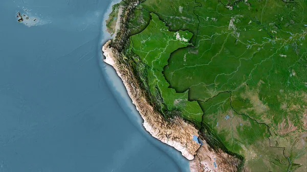
Peru Area On The Satellite C Map In The Stereographic Projection - Raw Composition Of Raster Layers With Dark Glowing Outline

Image, 5.94MB, 2880 × 1620 jpg
stock image Mean temperature of warmest quarter within the New Caledonia area in the stereographic projection with legend - main composition

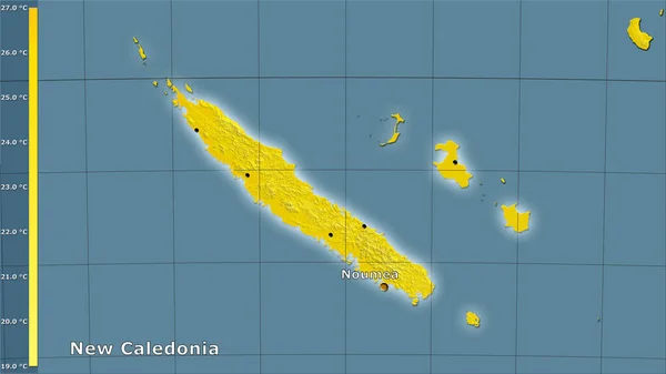
Mean Temperature Of Warmest Quarter Within The New Caledonia Area In The Stereographic Projection With Legend - Main Composition

Image, 1.15MB, 2880 × 1620 jpg
stock image New Zealand. Globe with the shape of the country against zoomed map with its outline isolated on the blue background. shapes only - land/ocean mask

New Zealand. Globe With The Shape Of The Country Against Zoomed Map With Its Outline Isolated On The Blue Background. Shapes Only - Land/ocean Mask

Image, 1.4MB, 2880 × 1620 jpg
stock image Zoomed-in view of Zimbabwe outline with perspective lines against a global map in the Kavrayskiy projection. Shape centered. satellite imagery

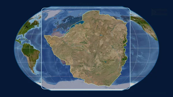
Zoomed-in View Of Zimbabwe Outline With Perspective Lines Against A Global Map In The Kavrayskiy Projection. Shape Centered. Satellite Imagery

Image, 3.11MB, 2880 × 1620 jpg
stock image World map in the Van Der Grinten projection centered on 11 East longitude. Bilevel topographic map - raw composite of raster with graticule. 3D illustration

World Map In The Van Der Grinten Projection Centered On 11 East Longitude. Bilevel Topographic Map - Raw Composite Of Raster With Graticule. 3D Illustration

Image, 2.1MB, 4000 × 2000 jpg
stock image World map in the Winkel Tripel projection centered on 11 East longitude. Satellite imagery B - raw composite of raster with graticule. 3D illustration

World Map In The Winkel Tripel Projection Centered On 11 East Longitude. Satellite Imagery B - Raw Composite Of Raster With Graticule. 3D Illustration

Image, 9.18MB, 4000 × 2000 jpg
stock image Brazil. Globe with the shape of the country against zoomed map with its outline isolated on the blue background. shapes only - land/ocean mask

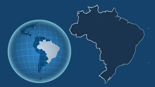
Brazil. Globe With The Shape Of The Country Against Zoomed Map With Its Outline Isolated On The Blue Background. Shapes Only - Land/ocean Mask

Image, 1.05MB, 2880 × 1620 jpg
stock image World map in the Braun Stereographic projection centered on 11 East longitude. Mean annual temperature map - raw composite of raster with graticule. 3D illustration

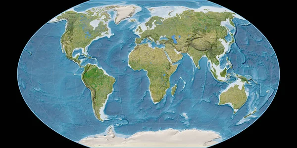
World Map In The Braun Stereographic Projection Centered On 11 East Longitude. Mean Annual Temperature Map - Raw Composite Of Raster With Graticule. 3D Illustration

Image, 3.4MB, 4000 × 2000 jpg
stock image Taiwan outlined on the satellite orthographic map. Capital, administrative borders and graticule

Taiwan Outlined On The Satellite Orthographic Map. Capital, Administrative Borders And Graticule

Image, 4.83MB, 3840 × 2160 jpg
stock vector USA and Canada large detailed political map and colorful map poi

USA And Canada Large Detailed Political Map And Colorful Map Poi

Vector, 13.46MB, 7006 × 8192 eps
stock vector Chile on the globe. Earth centered at the location of the Republic of Chile. Map of Chile. Includes layer with capital cities.

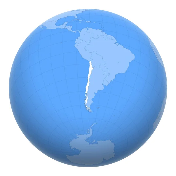
Chile On The Globe. Earth Centered At The Location Of The Republic Of Chile. Map Of Chile. Includes Layer With Capital Cities.

Vector, 3.1MB, 8000 × 8000 ai
stock image Afghanistan. Close-up perspective of the country - no outline. satellite imagery

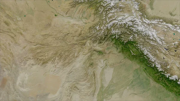
Afghanistan. Close-up Perspective Of The Country - No Outline. Satellite Imagery

Image, 5.39MB, 2880 × 1620 jpg
stock image Tajikistan area on the satellite B map in the stereographic projection - raw composition of raster layers with light glowing outline

Tajikistan Area On The Satellite B Map In The Stereographic Projection - Raw Composition Of Raster Layers With Light Glowing Outline

Image, 6.35MB, 2880 × 1620 jpg
stock image Mexico and its neighborhood. Distant oblique perspective - shape outlined. color physical map

Mexico And Its Neighborhood. Distant Oblique Perspective - Shape Outlined. Color Physical Map

Image, 3.59MB, 2880 × 1620 jpg
stock image Tajikistan area on the topographic relief map in the stereographic projection - raw composition of raster layers with light glowing outline

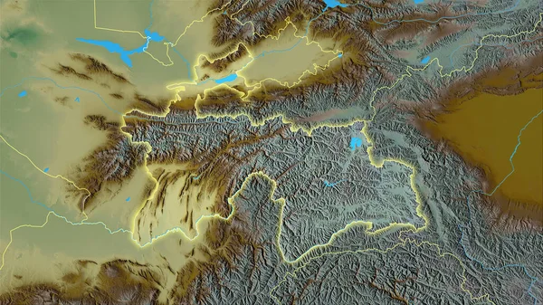
Tajikistan Area On The Topographic Relief Map In The Stereographic Projection - Raw Composition Of Raster Layers With Light Glowing Outline

Image, 7.08MB, 2880 × 1620 jpg
stock image Enlarged area of South Korea surrounded by a circle on the background of its neighborhood. Color physical map

Enlarged Area Of South Korea Surrounded By A Circle On The Background Of Its Neighborhood. Color Physical Map

Image, 2.85MB, 2880 × 1620 jpg
stock image Spain area on the annual precipitation map in the stereographic projection - raw composition of raster layers with dark glowing outline

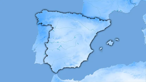
Spain Area On The Annual Precipitation Map In The Stereographic Projection - Raw Composition Of Raster Layers With Dark Glowing Outline

Image, 1.67MB, 2880 × 1620 jpg
stock image New Caledonia area on the satellite A map in the stereographic projection - raw composition of raster layers with light glowing outline

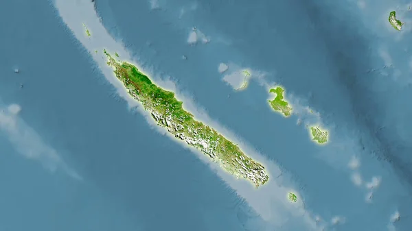
New Caledonia Area On The Satellite A Map In The Stereographic Projection - Raw Composition Of Raster Layers With Light Glowing Outline

Image, 2.19MB, 2880 × 1620 jpg
stock vector Functions of the synbiotic. Probiotic, prebiotic. Dysbacteriosis. Infographics. Vector illustration on isolated background.

Functions Of The Synbiotic. Probiotic, Prebiotic. Dysbacteriosis. Infographics. Vector Illustration On Isolated Background.

Vector, 0.76MB, 5000 × 4812 eps
stock image Ethiopia area on the satellite A map in the stereographic projection - raw composition of raster layers

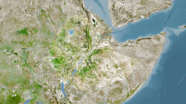
Ethiopia Area On The Satellite A Map In The Stereographic Projection - Raw Composition Of Raster Layers

Image, 6.57MB, 2880 × 1620 jpg
stock image World map in the Gall Stereographic projection centered on 11 East longitude. Colored shader, elevation map - raw composite of raster with graticule. 3D illustration

World Map In The Gall Stereographic Projection Centered On 11 East Longitude. Colored Shader, Elevation Map - Raw Composite Of Raster With Graticule. 3D Illustration

Image, 7.47MB, 4000 × 2000 jpg
stock image Guatemala and its neighborhood. Distant oblique perspective - shape outlined. satellite imagery

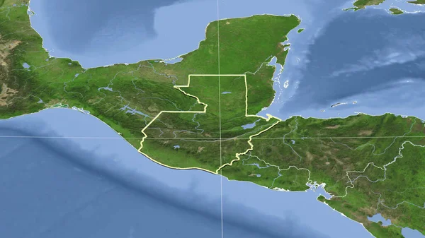
Guatemala And Its Neighborhood. Distant Oblique Perspective - Shape Outlined. Satellite Imagery

Image, 3.05MB, 2880 × 1620 jpg
stock image Spain area on the satellite C map in the stereographic projection - raw composition of raster layers

Spain Area On The Satellite C Map In The Stereographic Projection - Raw Composition Of Raster Layers

Image, 5.47MB, 2880 × 1620 jpg
stock image Malawi area on the satellite D map in the stereographic projection - main composition

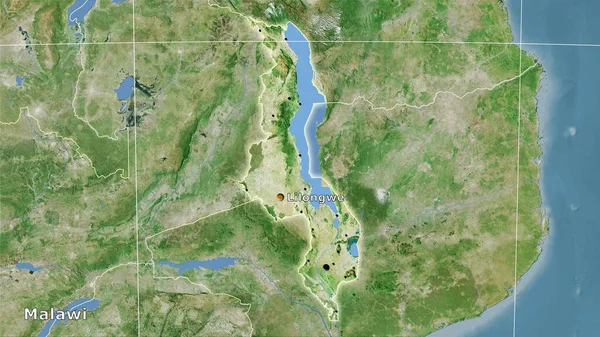
Malawi Area On The Satellite D Map In The Stereographic Projection - Main Composition

Image, 6.84MB, 2880 × 1620 jpg
stock image Romania area on the satellite A map in the stereographic projection - main composition

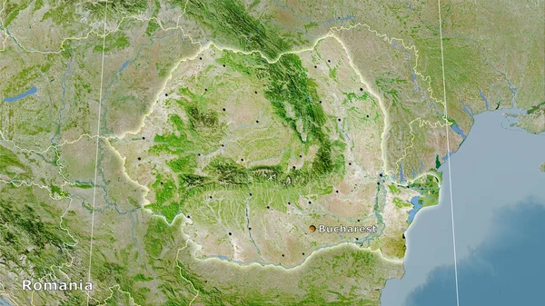
Romania Area On The Satellite A Map In The Stereographic Projection - Main Composition

Image, 7.64MB, 2880 × 1620 jpg
stock vector grid mesh, vector illustration

Grid Mesh, Vector Illustration

Vector, 0.32MB, 8334 × 8334 eps
stock vector Kazakhstan on the globe. Earth centered at the location of the Republic of Kazakhstan. Map of Kazakhstan. Includes layer with capital cities.

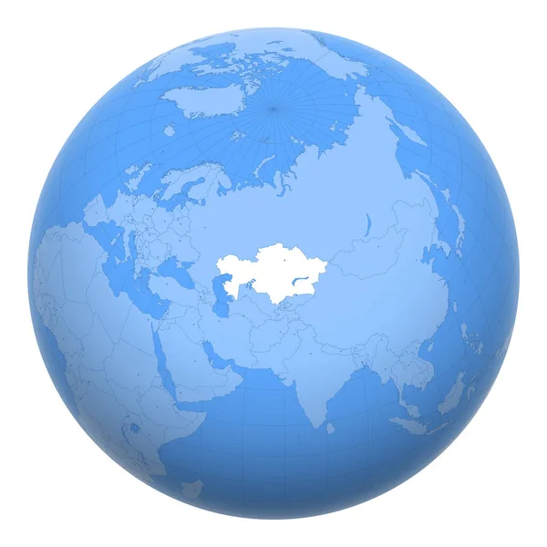
Kazakhstan On The Globe. Earth Centered At The Location Of The Republic Of Kazakhstan. Map Of Kazakhstan. Includes Layer With Capital Cities.

Vector, 7.8MB, 8000 × 8000 ai
stock image Costa Rica outlined on the relief orthographic map. Capital, administrative borders and graticule

Costa Rica Outlined On The Relief Orthographic Map. Capital, Administrative Borders And Graticule

Image, 4.62MB, 3840 × 2160 jpg
stock image World map in the Gall Stereographic projection centered on 11 East longitude. Main physiographic landscape features - raw composite of raster with graticule. 3D illustration

World Map In The Gall Stereographic Projection Centered On 11 East Longitude. Main Physiographic Landscape Features - Raw Composite Of Raster With Graticule. 3D Illustration

Image, 7.6MB, 4000 × 2000 jpg
stock image Taiwan area on the satellite B map in the stereographic projection - raw composition of raster layers

Taiwan Area On The Satellite B Map In The Stereographic Projection - Raw Composition Of Raster Layers

Image, 3.08MB, 2880 × 1620 jpg
stock vector Wireframe, grid, mesh sphere, globe, ball vector illustration

Wireframe, Grid, Mesh Sphere, Globe, Ball Vector Illustration

Vector, 0.39MB, 8334 × 8334 eps
stock image Zoomed-in view of Congo Kinshasa outline with perspective lines against a global map in the Mollweide projection. Shape on the left side. satellite imagery

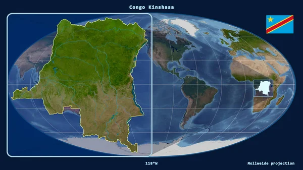
Zoomed-in View Of Congo Kinshasa Outline With Perspective Lines Against A Global Map In The Mollweide Projection. Shape On The Left Side. Satellite Imagery

Image, 3.24MB, 2880 × 1620 jpg
stock vector World map navy blue colors and glossy style globes

World Map Navy Blue Colors And Glossy Style Globes

Vector, 12.63MB, 8192 × 4261 eps
stock image Colombia area on the satellite D map in the stereographic projection - raw composition of raster layers with light glowing outline

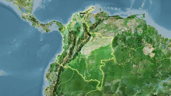
Colombia Area On The Satellite D Map In The Stereographic Projection - Raw Composition Of Raster Layers With Light Glowing Outline

Image, 6.11MB, 2880 × 1620 jpg
stock image Sweden area on the topographic relief map in the stereographic projection - raw composition of raster layers with light glowing outline

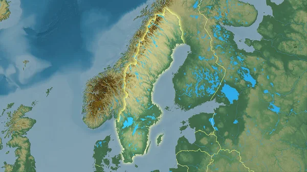
Sweden Area On The Topographic Relief Map In The Stereographic Projection - Raw Composition Of Raster Layers With Light Glowing Outline

Image, 5.03MB, 2880 × 1620 jpg
stock vector Antarctic map

Antarctic Map

Vector, 1.27MB, 3544 × 3544 eps
stock image Shadow above and behind a Riflescope with a magnification range of four to 12 with an objective lens that has a crimson tint

Shadow Above And Behind A Riflescope With A Magnification Range Of Four To 12 With An Objective Lens That Has A Crimson Tint

Image, 3.29MB, 4256 × 4296 jpg
stock image Sunshine, blue sky and glass ceiling

Sunshine, Blue Sky And Glass Ceiling

Image, 7.49MB, 6109 × 4073 jpg
stock vector White gradient backdrop on transparency grid. Abstract vector background. Graphic element suitable for design or digital art.

White Gradient Backdrop On Transparency Grid. Abstract Vector Background. Graphic Element Suitable For Design Or Digital Art.

Vector, 1.78MB, 12000 × 6000 eps
stock vector Kyrgyzstan (Kirghizia) on the globe. Earth centered at the location of the Kyrgyz Republic. Map of Kyrgyzstan. Includes layer with capital cities.

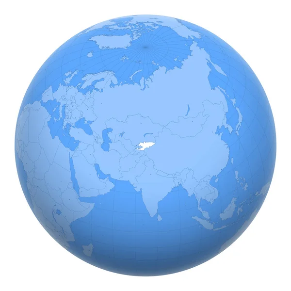
Kyrgyzstan (Kirghizia) On The Globe. Earth Centered At The Location Of The Kyrgyz Republic. Map Of Kyrgyzstan. Includes Layer With Capital Cities.

Vector, 7.7MB, 8000 × 8000 ai
stock image Colombia extruded on the relief orthographic map. Capital, administrative borders and graticule

Colombia Extruded On The Relief Orthographic Map. Capital, Administrative Borders And Graticule

Image, 6.69MB, 3840 × 2160 jpg
stock image Jordan outlined on the satellite orthographic map. Capital, administrative borders and graticule

Jordan Outlined On The Satellite Orthographic Map. Capital, Administrative Borders And Graticule

Image, 5.04MB, 3840 × 2160 jpg
stock image Precipitation of driest quarter within the India area in the stereographic projection with legend - raw composition of raster layers

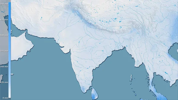
Precipitation Of Driest Quarter Within The India Area In The Stereographic Projection With Legend - Raw Composition Of Raster Layers

Image, 3.41MB, 2880 × 1620 jpg
stock image Norway. Globe with the shape of the country against zoomed map with its outline isolated on the blue background. color physical map

Norway. Globe With The Shape Of The Country Against Zoomed Map With Its Outline Isolated On The Blue Background. Color Physical Map

Image, 2.12MB, 2880 × 1620 jpg
stock image Austria and its neighborhood. Distant oblique perspective - no outline. color physical map

Austria And Its Neighborhood. Distant Oblique Perspective - No Outline. Color Physical Map

Image, 5.53MB, 2880 × 1620 jpg
stock image France. Close-up perspective of the country - no outline. topographic relief map

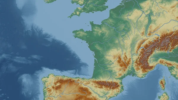
France. Close-up Perspective Of The Country - No Outline. Topographic Relief Map

Image, 3.83MB, 2880 × 1620 jpg
stock image Mauritius. Globe with the shape of the country against zoomed map with its outline isolated on the blue background. satellite imagery

Mauritius. Globe With The Shape Of The Country Against Zoomed Map With Its Outline Isolated On The Blue Background. Satellite Imagery

Image, 2.58MB, 2880 × 1620 jpg
stock image Maximum temperature of warmest month within the Netherlands area in the stereographic projection with legend - raw composition of raster layers with light glowing outline

Maximum Temperature Of Warmest Month Within The Netherlands Area In The Stereographic Projection With Legend - Raw Composition Of Raster Layers With Light Glowing Outline

Image, 3.57MB, 2880 × 1620 jpg
stock image World map in the Miller Cylindrical projection centered on 11 East longitude. Mean annual temperature map - raw composite of raster with graticule. 3D illustration

World Map In The Miller Cylindrical Projection Centered On 11 East Longitude. Mean Annual Temperature Map - Raw Composite Of Raster With Graticule. 3D Illustration

Image, 3.05MB, 4000 × 2000 jpg
Page 1 >> Next