
Stock image Ile De Mansel

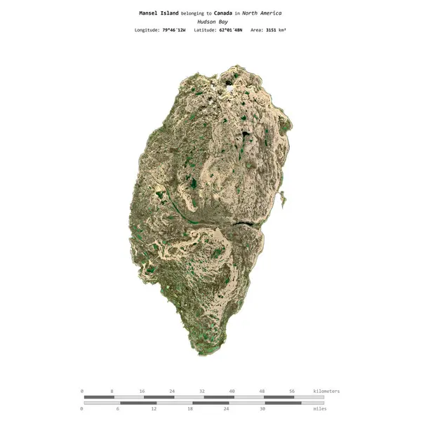
Mansel Island In The Hudson Bay, Belonging To Canada, Isolated On A Satellite Image Taken In July 29, 2020, With Distance Scale
Image, 1.7MB, 2160 × 2160 jpg

Mansel Island In The Hudson Bay On A Satellite Image Taken In September 10, 2021
Image, 3.13MB, 2880 × 1620 jpg

Mugello Circuit, 25 October 2019: F1 Ferrari F189 Year 1989 Ex Nigel Mansell On Display During Finali Mondiali Ferrari 2019 At Mugello Circuit In Italy.
Image, 14.67MB, 5568 × 3712 jpg

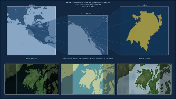
Marble Island In The The Coastal Waters Of Southeast Alaska And British Columbia, Belonging To United States, Isolated On A Bilevel Elevation Map, With Distance Scale
Image, 0.42MB, 2160 × 2160 jpg

Ilha Da Marambaia In The South Atlantic Ocean, Belonging To Brazil, Isolated On A Topographic, OSM Humanitarian Style Map, With Distance Scale
Image, 0.35MB, 2160 × 2160 jpg
Mansel Island In The Hudson Bay On A Topographic, OSM Humanitarian Style Map
Image, 1.11MB, 2880 × 1620 jpg

Bulls, A Small Town In The Lower North Island Of New Zealand. Historic Early 20th Century Buildings On State Highway 3, With The Rangitikei Tavern In The Background. August 9 2021
Image, 12.53MB, 5760 × 3840 jpg

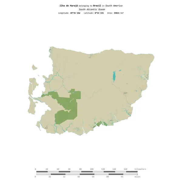
Ilha De Marajo In The South Atlantic Ocean, Belonging To Brazil, Isolated On A Bilevel Elevation Map, With Distance Scale
Image, 0.77MB, 2160 × 2160 jpg


Marble Island In The The Coastal Waters Of Southeast Alaska And British Columbia, Belonging To United States, Isolated On A Topographic, OSM Humanitarian Style Map, With Distance Scale
Image, 0.71MB, 2160 × 2160 jpg

Pulau Mapur In The South China Sea, Belonging To Indonesia, Isolated On A Bilevel Elevation Map, With Distance Scale
Image, 0.3MB, 2160 × 2160 jpg

Imola, 27 April 2019: Historic 1992 F1 Williams FW14B Ex Riccardo Patrese - Nigel Mansell Driven By Riccardo Patrese During Minardi Historic Day 2019 At Imola Circuit In Italy.
Image, 12.89MB, 5568 × 3712 jpg

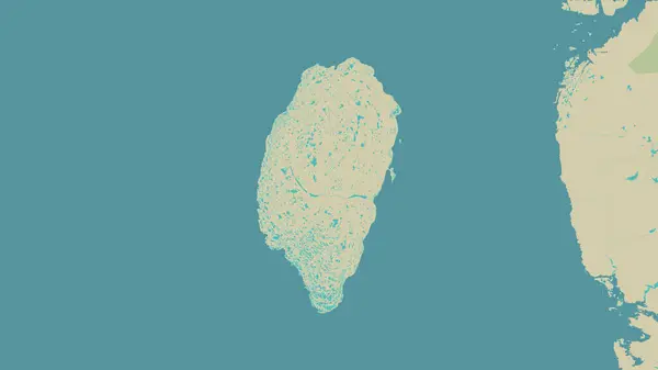
Mansel Island In The Hudson Bay, Belonging To Canada, Isolated On A Bilevel Elevation Map, With Distance Scale
Image, 0.69MB, 2160 × 2160 jpg


Manus Island In The Bismarck Sea, Belonging To Papua New Guinea, Isolated On A Topographic, OSM Humanitarian Style Map, With Distance Scale
Image, 0.43MB, 2160 × 2160 jpg

Pulau Mapur In The South China Sea, Belonging To Indonesia, Isolated On A Topographic, OSM Humanitarian Style Map, With Distance Scale
Image, 0.5MB, 2160 × 2160 jpg
Marble Island In The The Coastal Waters Of Southeast Alaska And British Columbia - Belonging To United States. Described Location Diagram With Yellow Shape Of The Island And Sample Maps Of Its Surroundings
Image, 2.89MB, 3840 × 2160 jpg


Ilha De Maraca In The North Atlantic Ocean, Belonging To Brazil, Isolated On A Topographic, OSM Humanitarian Style Map, With Distance Scale
Image, 0.32MB, 2160 × 2160 jpg
Ilha De Marajo In The South Atlantic Ocean, Belonging To Brazil, Isolated On A Topographic, OSM Humanitarian Style Map, With Distance Scale
Image, 0.69MB, 2160 × 2160 jpg

Ilha Da Marambaia In The South Atlantic Ocean, Belonging To Brazil, Isolated On A Bilevel Elevation Map, With Distance Scale
Image, 0.23MB, 2160 × 2160 jpg

Ilha De Maraca In The North Atlantic Ocean - Belonging To Brazil. Described Location Diagram With Yellow Shape Of The Island And Sample Maps Of Its Surroundings
Image, 2.01MB, 3840 × 2160 jpg

Mansel Island In The Hudson Bay, Belonging To Canada, Isolated On A Topographic, OSM Humanitarian Style Map, With Distance Scale
Image, 1.33MB, 2160 × 2160 jpg
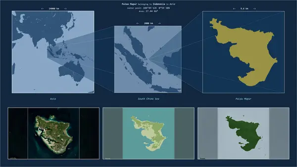
Pulau Mapur In The South China Sea - Belonging To Indonesia. Described Location Diagram With Yellow Shape Of The Island And Sample Maps Of Its Surroundings
Image, 1.97MB, 3840 × 2160 jpg

Ilha De Marajo In The South Atlantic Ocean - Belonging To Brazil. Described Location Diagram With Yellow Shape Of The Island And Sample Maps Of Its Surroundings
Image, 3.35MB, 3840 × 2160 jpg

Manus Island In The Bismarck Sea, Belonging To Papua New Guinea, Isolated On A Bilevel Elevation Map, With Distance Scale
Image, 0.49MB, 2160 × 2160 jpg

Marble Island In The The Coastal Waters Of Southeast Alaska And British Columbia, Belonging To United States, Isolated On A Bilevel Elevation Map, With Distance Scale
Image, 0.42MB, 2160 × 2160 jpg

Ilha Da Marambaia In The South Atlantic Ocean - Belonging To Brazil. Described Location Diagram With Yellow Shape Of The Island And Sample Maps Of Its Surroundings
Image, 2.32MB, 3840 × 2160 jpg
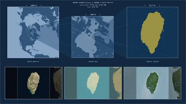
Mansel Island In The Hudson Bay - Belonging To Canada. Described Location Diagram With Yellow Shape Of The Island And Sample Maps Of Its Surroundings
Image, 2.1MB, 3840 × 2160 jpg
Page 1 >> Next