photo free
Home Images Vectors Videos

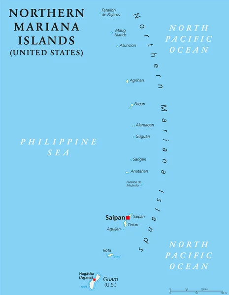
Stock image Mariana Archipelago

stock vector Northern Mariana Islands political map

Northern Mariana Islands Political Map

Vector, 2.05MB, 6444 × 9666 eps
stock vector Northern Mariana Islands political map

Northern Mariana Islands Political Map

Vector, 2.47MB, 6974 × 8999 eps
stock image Anak Krakatau erupting

Anak Krakatau Erupting

Image, 3.68MB, 2500 × 2500 jpg
stock image Anak Krakatau erupting

Anak Krakatau Erupting

Image, 3.41MB, 4000 × 2250 jpg
stock image Anak Krakatau erupting

Anak Krakatau Erupting

Image, 3.19MB, 6000 × 3375 jpg
stock image Anak Krakatau erupting

Anak Krakatau Erupting

Image, 3.68MB, 2250 × 2250 jpg
stock image Anak Krakatau erupting

Anak Krakatau Erupting

Image, 1.02MB, 4000 × 2608 jpg
stock vector USA - Free Associated States and Unincorporated Territories Flag

USA - Free Associated States And Unincorporated Territories Flag

Vector, 3.11MB, 5078 × 5233 eps
stock vector Map of Guam a non incorporated territory of the United States

Map Of Guam A Non Incorporated Territory Of The United States

Vector, 1.02MB, 3113 × 3288 eps
stock vector Vector map of the Mariana Islands and the Mariana Trench, U.S

Vector Map Of The Mariana Islands And The Mariana Trench, U.S

Vector, 1.95MB, 3100 × 4990 eps
stock vector Farallon de Medinilla Island (Commonwealth of the Northern Mariana Islands, Pacific Ocean, United States of America, USA) map vector illustration, scribble sketch map

Farallon De Medinilla Island (Commonwealth Of The Northern Mariana Islands, Pacific Ocean, United States Of America, USA) Map Vector Illustration, Scribble Sketch Map

Vector, 0.8MB, 7087 × 4726 eps
stock vector Saipan and Tinian, Northern Mariana Islands, gray political map. Islands of the Mariana Archipelago. Unincorporated territory and commonwealth of United States with administrative center Capitol Hill.

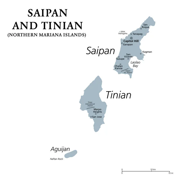
Saipan And Tinian, Northern Mariana Islands, Gray Political Map. Islands Of The Mariana Archipelago. Unincorporated Territory And Commonwealth Of United States With Administrative Center Capitol Hill.

Vector, 1.42MB, 6000 × 6000 eps
stock image Anak Krakatau erupting

Anak Krakatau Erupting

Image, 0.72MB, 2567 × 1888 jpg
stock vector Guam and Northern Mariana Islands, gray political map. Two separate unincorporated territories of the United States of America in the Micronesia subregion of the Western Pacific Ocean. Illustration.

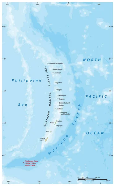
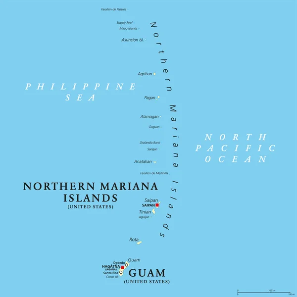
Guam And Northern Mariana Islands, Gray Political Map. Two Separate Unincorporated Territories Of The United States Of America In The Micronesia Subregion Of The Western Pacific Ocean. Illustration.

Vector, 2.02MB, 6000 × 8996 eps
stock vector Guam and Northern Mariana Islands, political map. Two separate unincorporated territories of the United States of America in the Micronesia subregion of the Western Pacific Ocean. Illustration. Vector

Guam And Northern Mariana Islands, Political Map. Two Separate Unincorporated Territories Of The United States Of America In The Micronesia Subregion Of The Western Pacific Ocean. Illustration. Vector

Vector, 3.12MB, 6000 × 6000 eps
Page 1 >> Next