photo free
Home Images Vectors Videos

Stock image Marion Border

stock vector The Missouri State county map with labels

The Missouri State County Map With Labels

Vector, 9.94MB, 5000 × 5000 eps
stock image iowa state cities list

Iowa State Cities List

Image, 12.9MB, 4055 × 2372 jpg
stock image Iowa state cities list

Iowa State Cities List

Image, 1.54MB, 3800 × 2100 jpg
stock vector 19 of 50 sets, US State Posters with name and Information in 3 Design Styles, Detailed vector art print Indiana map

19 Of 50 Sets, US State Posters With Name And Information In 3 Design Styles, Detailed Vector Art Print Indiana Map

Vector, 1.83MB, 8896 × 4168 eps
stock vector Florida County Map

Florida County Map

Vector, 0.8MB, 4545 × 5000 ai
stock vector Ohio County Map

Ohio County Map

Vector, 1.69MB, 5000 × 4167 ai
stock vector 19 of 50 states of the United States with a name, nickname, and

19 Of 50 States Of The United States With A Name, Nickname, And

Vector, 0.75MB, 7311 × 4112 eps
stock image iowa state cities list

Iowa State Cities List

Image, 1.43MB, 3840 × 2160 jpg
stock vector Florida County Map

Florida County Map

Vector, 0.88MB, 4545 × 5000 ai
stock image Map of Marion County in Texas state on white background. single County map highlighted by black colour on Texas map. UNITED STATES, US

Map Of Marion County In Texas State On White Background. Single County Map Highlighted By Black Colour On Texas Map. UNITED STATES, US

Image, 6.5MB, 8000 × 8000 jpg
stock image Map of Marion County in Florida state on white background. single County map highlighted by black colour on Florida map. UNITED STATES, US

Map Of Marion County In Florida State On White Background. Single County Map Highlighted By Black Colour On Florida Map. UNITED STATES, US

Image, 5.84MB, 8000 × 8000 jpg
stock vector Indiana counties, gray political map. State in the Midwestern region of the United States, subdivided into 92 counties. Nicknamed The Hoosier State. Map with borders and county names. Illustration

Indiana Counties, Gray Political Map. State In The Midwestern Region Of The United States, Subdivided Into 92 Counties. Nicknamed The Hoosier State. Map With Borders And County Names. Illustration

Vector, 2.01MB, 6000 × 8826 eps
stock vector Ohio County Map

Ohio County Map

Vector, 1.01MB, 5000 × 4167 ai
stock vector Indiana counties, political map. State in the Midwestern region of the United States, subdivided into 92 counties. Nicknamed The Hoosier State. Map with borders and county names. Illustration

Indiana Counties, Political Map. State In The Midwestern Region Of The United States, Subdivided Into 92 Counties. Nicknamed The Hoosier State. Map With Borders And County Names. Illustration

Vector, 2.42MB, 6000 × 9000 eps
stock vector Marion (South Australia) outline map set

Marion (South Australia) Outline Map Set

Vector, 0.33MB, 6000 × 3000 eps
stock image Map of Marion County in Ohio state on white background. single County map highlighted by black colour on Ohio map. UNITED STATES, US

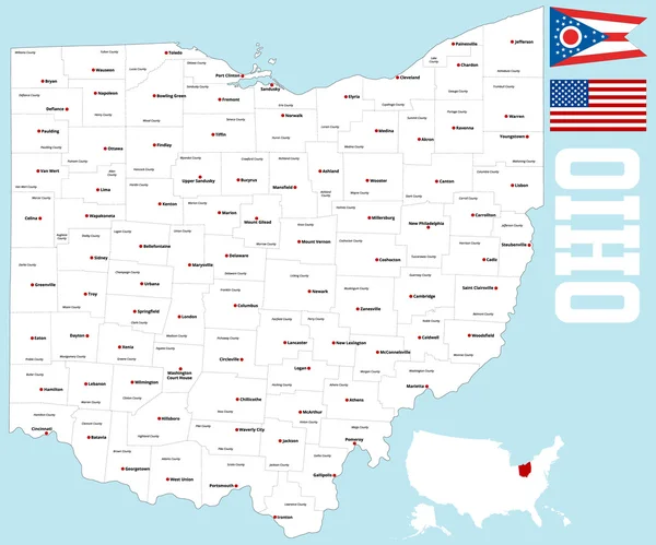
Map Of Marion County In Ohio State On White Background. Single County Map Highlighted By Black Colour On Ohio Map. UNITED STATES, US

Image, 5.59MB, 8000 × 8000 jpg
stock image Iowa cities list

Iowa Cities List

Image, 4.49MB, 5000 × 3000 jpg
stock image Map of Marion County in Illinois state on white background. single County map highlighted by black colour on Illinois map. UNITED STATES, US

Map Of Marion County In Illinois State On White Background. Single County Map Highlighted By Black Colour On Illinois Map. UNITED STATES, US

Image, 5.19MB, 8000 × 8000 jpg
stock image Map of Marion County in Georgia state on white background. single County map highlighted by black colour on Georgia map. UNITED STATES, US

Map Of Marion County In Georgia State On White Background. Single County Map Highlighted By Black Colour On Georgia Map. UNITED STATES, US

Image, 6.57MB, 8000 × 8000 jpg
stock vector Oregon counties, gray political map with borders and county names. State in the Pacific Northwest region of the United States, subdivided into 36 counties. Nicknamed The Beaver State. Illustration.

Oregon Counties, Gray Political Map With Borders And County Names. State In The Pacific Northwest Region Of The United States, Subdivided Into 36 Counties. Nicknamed The Beaver State. Illustration.

Vector, 2.19MB, 7830 × 6000 eps
stock vector Oregon counties, political map with borders and county names. State in the Pacific Northwest region of the United States, subdivided into 36 counties. Nicknamed The Beaver State. Illustration. Vector

Oregon Counties, Political Map With Borders And County Names. State In The Pacific Northwest Region Of The United States, Subdivided Into 36 Counties. Nicknamed The Beaver State. Illustration. Vector

Vector, 2.81MB, 7870 × 6000 eps
Page 1 >> Next