photo free
Home Images Vectors Videos

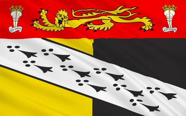
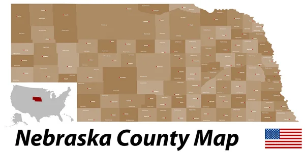
Stock image Norfolk County

stock image Flag of Norfolk county, England

Flag Of Norfolk County, England

Image, 2.37MB, 3072 × 1920 jpg
stock image Oxburgh Hall, Oxborough, Norfolk County, East Anglia, England

Oxburgh Hall, Oxborough, Norfolk County, East Anglia, England

Image, 18.14MB, 5572 × 3715 jpg
stock vector Massachusetts County Map

Massachusetts County Map

Vector, 0.6MB, 5000 × 3000 ai
stock vector Massachusetts map

Massachusetts Map

Vector, 4.33MB, 5502 × 4691 eps
stock vector Massachusetts County Map

Massachusetts County Map

Vector, 0.54MB, 5000 × 3000 ai
stock vector The detailed map of the United Kingdom with regions or states and cities, capitals. Actual current relevant UK, Great Britain administrative devision.

The Detailed Map Of The United Kingdom With Regions Or States And Cities, Capitals. Actual Current Relevant UK, Great Britain Administrative Devision.

Vector, 2.56MB, 5000 × 6500 eps
stock vector The detailed map of the United Kingdom with regions or states and cities, capitals. Actual current relevant UK, Great Britain administrative devision.

The Detailed Map Of The United Kingdom With Regions Or States And Cities, Capitals. Actual Current Relevant UK, Great Britain Administrative Devision.

Vector, 2.52MB, 5000 × 6500 eps
stock vector Virginia state detailed editable map

Virginia State Detailed Editable Map

Vector, 1.3MB, 7724 × 4000 eps
stock vector vector map of United Kingdom colored by countries, counties and regions

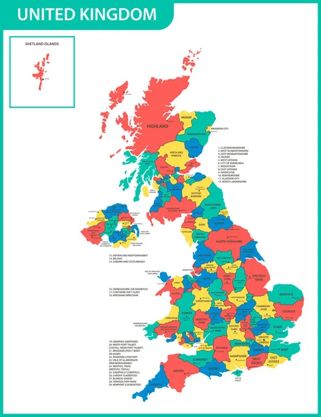
Vector Map Of United Kingdom Colored By Countries, Counties And Regions

Vector, 10.75MB, 5458 × 7292 eps
stock vector Nebraska County Map

Nebraska County Map

Vector, 0.76MB, 6000 × 3000 ai
stock vector vector map of England ceremonial counties. Flag of England. Navigation and location icons

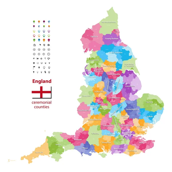
Vector Map Of England Ceremonial Counties. Flag Of England. Navigation And Location Icons

Vector, 9.37MB, 7292 × 7292 eps
stock vector United Kingdom administrative districts vector high detailed map colored by regions and counties

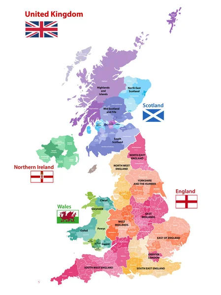
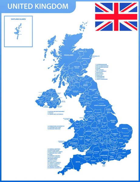
United Kingdom Administrative Districts Vector High Detailed Map Colored By Regions And Counties

Vector, 10MB, 5144 × 8333 eps
stock vector Virginia County Map

Virginia County Map

Vector, 1.44MB, 5507 × 3000 ai
stock vector High quality colorful labeled map of England with borders of the counties

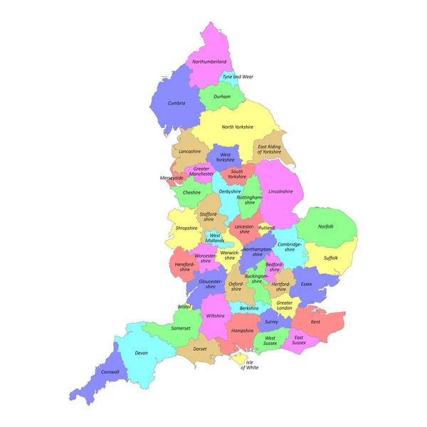
High Quality Colorful Labeled Map Of England With Borders Of The Counties

Vector, 3MB, 4000 × 4000 eps
stock vector Nebraska county map

Nebraska County Map

Vector, 0.8MB, 6000 × 3000 ai
stock image Norfolk, administrative county of England - Great Britain. High resolution satellite map. Locations of major cities of the region. Corner auxiliary location maps

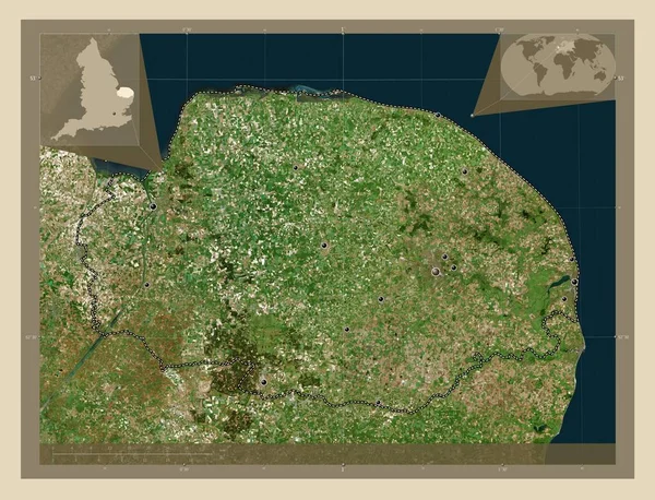
Norfolk, Administrative County Of England - Great Britain. High Resolution Satellite Map. Locations Of Major Cities Of The Region. Corner Auxiliary Location Maps

Image, 9.85MB, 4930 × 3770 jpg
stock vector The detailed map of the United Kingdom with regions or states and cities, capitals. Actual current relevant UK, Great Britain administrative devision.

The Detailed Map Of The United Kingdom With Regions Or States And Cities, Capitals. Actual Current Relevant UK, Great Britain Administrative Devision.

Vector, 2.61MB, 5000 × 6500 eps
stock image Clifton, VA, USA 11/14/2020: Historic Clifton, established in 1862, is a small  picturesque town in Fairfax county with many 19th century houses. Image features an autumn city scape.

Clifton, VA, USA 11/14/2020: Historic Clifton, Established In 1862, Is A Small Picturesque Town In Fairfax County With Many 19th Century Houses. Image Features An Autumn City Scape.

Image, 10.39MB, 5019 × 3346 jpg
stock image County Flags of the United Kingdom

County Flags Of The United Kingdom

Image, 4.97MB, 3812 × 3210 jpg
stock vector Norfolk in England, UK, vintage engraved illustration

Norfolk In England, UK, Vintage Engraved Illustration

Vector, 11.86MB, 7733 × 2774 eps
stock image Norfolk, Connecticut, USA A country road at sunset

Norfolk, Connecticut, USA A Country Road At Sunset

Image, 13.77MB, 5472 × 3648 jpg
stock image An Old style tobacco kiln at sunset

An Old Style Tobacco Kiln At Sunset

Image, 7.59MB, 4366 × 2906 jpg
stock image Norfolk County flag

Norfolk County Flag

Image, 1.04MB, 3000 × 1800 jpg
stock image List of cities in Virginia USA state, map silhouette word cloud map concept background

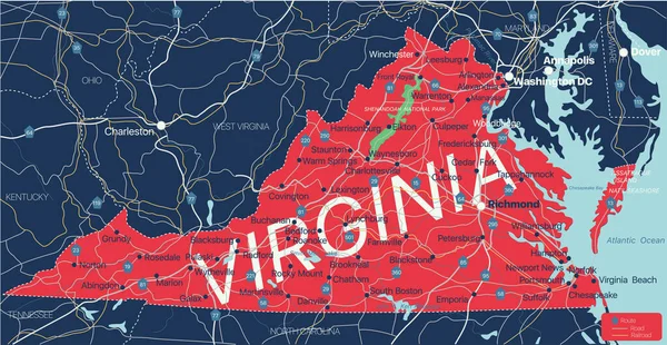
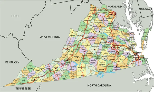
List Of Cities In Virginia USA State, Map Silhouette Word Cloud Map Concept Background

Image, 9.08MB, 12500 × 8333 jpg
stock vector Flag of Norfolk Island. Vector Format

Flag Of Norfolk Island. Vector Format

Vector, 5.88MB, 8252 × 5500 eps
stock image Colourful beach huts by the sea in Sheringham, Norfolk, UK, peop

Colourful Beach Huts By The Sea In Sheringham, Norfolk, UK, Peop

Image, 9.59MB, 6000 × 4000 jpg
stock image Norfolk, administrative county of England - Great Britain. Elevation map colored in wiki style with lakes and rivers

Norfolk, Administrative County Of England - Great Britain. Elevation Map Colored In Wiki Style With Lakes And Rivers

Image, 5.83MB, 3840 × 2880 jpg
stock vector Norfolk map, ceremonial county of England. Vector illustration.

Norfolk Map, Ceremonial County Of England. Vector Illustration.

Vector, 5.32MB, 8334 × 8334 eps
stock vector Symbol Map of the Administrative County Norfolk (United Kingdom) showing the state/province with a pattern of black squares like a chessboard

Symbol Map Of The Administrative County Norfolk (United Kingdom) Showing The State/province With A Pattern Of Black Squares Like A Chessboard

Vector, 0.61MB, 6000 × 4090 eps
stock image Map of Norfolk County in Massachusetts state on white background. single County map highlighted by black colour on Massachusetts map. UNITED STATES, US

Map Of Norfolk County In Massachusetts State On White Background. Single County Map Highlighted By Black Colour On Massachusetts Map. UNITED STATES, US

Image, 4.1MB, 8000 × 6667 jpg
stock vector Circle badge Norfolk flag button vector illustration isolated, East of England, United Kingdom. Roundel Norfolk emblem banner. National symbol.

Circle Badge Norfolk Flag Button Vector Illustration Isolated, East Of England, United Kingdom. Roundel Norfolk Emblem Banner. National Symbol.

Vector, 0.22MB, 5000 × 5000 eps
stock vector High detailed Virginia road map with labeling.

High Detailed Virginia Road Map With Labeling.

Vector, 9.73MB, 5550 × 3318 eps
stock vector Norfolk County (Canada, Ontario Province, North America) map vector illustration, scribble sketch Norfolk map

Norfolk County (Canada, Ontario Province, North America) Map Vector Illustration, Scribble Sketch Norfolk Map

Vector, 1.46MB, 7087 × 4726 eps
stock image Norfolk independent city location highlighted by black color on Virginia state map, United States, usa, us

Norfolk Independent City Location Highlighted By Black Color On Virginia State Map, United States, Usa, Us

Image, 4.46MB, 8000 × 5334 jpg
stock image Map of Norfolk County in Massachusetts state on white background. single County map highlighted by black colour on Massachusetts map. UNITED STATES, US

Map Of Norfolk County In Massachusetts State On White Background. Single County Map Highlighted By Black Colour On Massachusetts Map. UNITED STATES, US

Image, 4.4MB, 8000 × 6667 jpg
stock image Train tracks in Clifton Virginia near Clifton Station, where the VRE and Amtrak trains run through

Train Tracks In Clifton Virginia Near Clifton Station, Where The VRE And Amtrak Trains Run Through

Image, 23.85MB, 7008 × 4672 jpg
stock vector High detailed Virginia physical map with labeling.

High Detailed Virginia Physical Map With Labeling.

Vector, 10.27MB, 5550 × 3318 eps
stock vector Massachusetts, U.S. state, multi colored political map with borders, county names and capital Boston. State in the New England region of the Northeastern United States, subdivided into 14 counties.

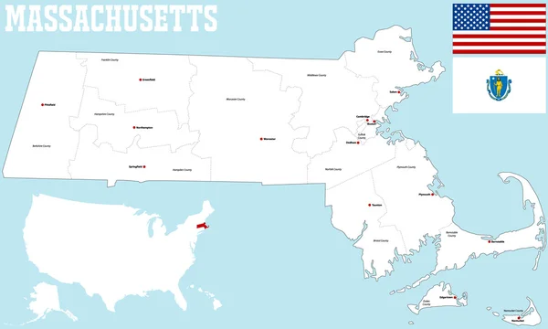
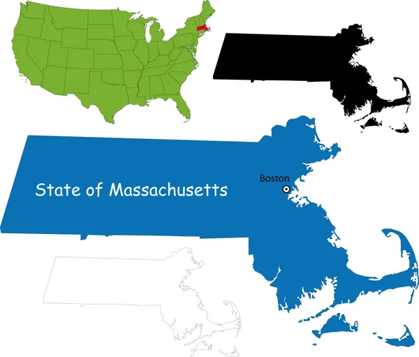
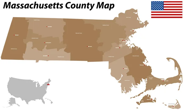
Massachusetts, U.S. State, Multi Colored Political Map With Borders, County Names And Capital Boston. State In The New England Region Of The Northeastern United States, Subdivided Into 14 Counties.

Vector, 2.14MB, 9000 × 5580 eps
stock vector Virginia - Highly detailed editable political map with labeling.

Virginia - Highly Detailed Editable Political Map With Labeling.

Vector, 9.86MB, 5550 × 3318 eps
Page 1 >> Next