photo free
Home Images Vectors Videos

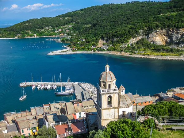
Stock image Saint Lawrence Gulf

stock image View of Perce Rock at summer

View Of Perce Rock At Summer

Image, 9.5MB, 4200 × 2800 jpg
stock image View of Gulf of Saint Lawrence from Perce village trail at summer sunset

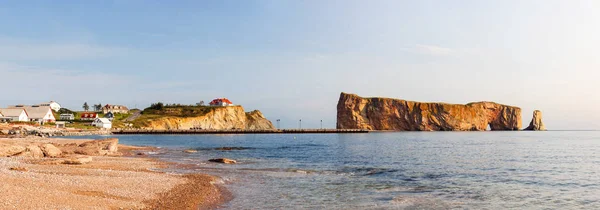
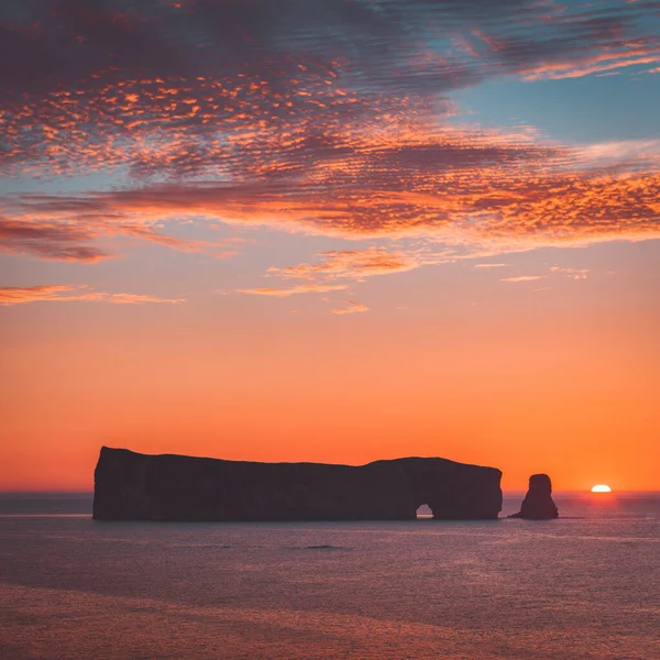
View Of Gulf Of Saint Lawrence From Perce Village Trail At Summer Sunset

Image, 6.07MB, 3200 × 2133 jpg
stock image View of Perce Rock at summer

View Of Perce Rock At Summer

Image, 5.74MB, 3673 × 2000 jpg
stock vector  Map of the four canada atlantic provinces

Map Of The Four Canada Atlantic Provinces

Vector, 1.73MB, 3100 × 4889 eps
stock vector New Brunswick, Maritime and Atlantic province of Canada, political map. Bordered to Quebec, Nova Scotia, Gulf of St. Lawrence, Bay of Fundy and US state Maine, with capital Fredericton. Illustration.

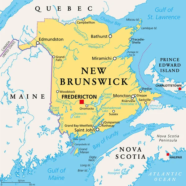
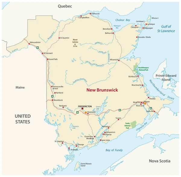
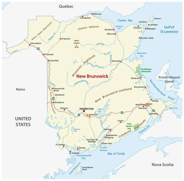
New Brunswick, Maritime And Atlantic Province Of Canada, Political Map. Bordered To Quebec, Nova Scotia, Gulf Of St. Lawrence, Bay Of Fundy And US State Maine, With Capital Fredericton. Illustration.

Vector, 4.74MB, 6000 × 6000 eps
stock image Forillon National Park Landscape, Quebec, Canada

Forillon National Park Landscape, Quebec, Canada

Image, 12.59MB, 5769 × 3846 jpg
stock vector Vector road map of the four canada atlantic provinces

Vector Road Map Of The Four Canada Atlantic Provinces

Vector, 2.13MB, 3100 × 4561 eps
stock image Forillon National Park Landscape, Quebec, Canada

Forillon National Park Landscape, Quebec, Canada

Image, 36.26MB, 12556 × 3326 jpg
stock image Forillon National Park Landscape, Quebec, Canada

Forillon National Park Landscape, Quebec, Canada

Image, 10.33MB, 5769 × 3846 jpg
stock image Jacques Cartier was the first European to describe and map the Gulf of Saint Lawrence and the shores of the Saint Lawrence River

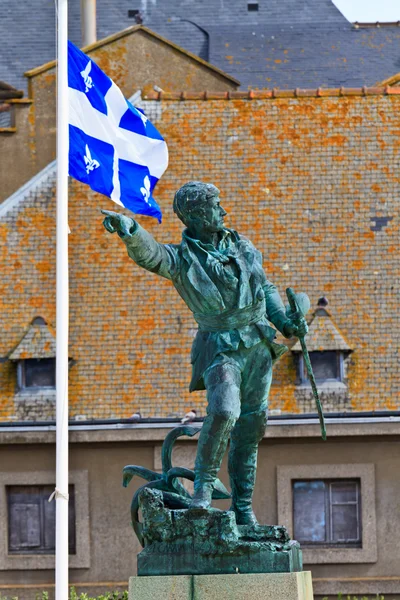
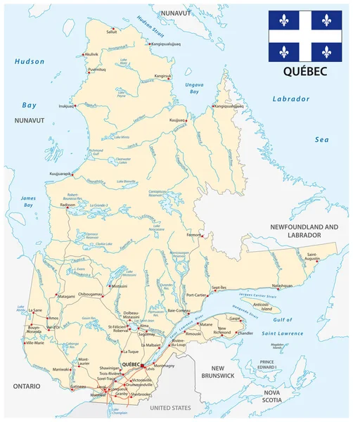
Jacques Cartier Was The First European To Describe And Map The Gulf Of Saint Lawrence And The Shores Of The Saint Lawrence River

Image, 18.44MB, 6372 × 8412 jpg
stock image Forillon National Park Landscape, Quebec, Canada

Forillon National Park Landscape, Quebec, Canada

Image, 16.29MB, 8508 × 3142 jpg
stock image Forillon National Park Landscape, Quebec, Canada

Forillon National Park Landscape, Quebec, Canada

Image, 13.68MB, 5901 × 3324 jpg
stock image Forillon National Park Landscape, Quebec, Canada

Forillon National Park Landscape, Quebec, Canada

Image, 17.14MB, 3936 × 5904 jpg
stock image Forillon National Park Landscape, Quebec, Canada

Forillon National Park Landscape, Quebec, Canada

Image, 26.54MB, 11023 × 3170 jpg
stock image Forillon National Park Landscape, Quebec, Canada

Forillon National Park Landscape, Quebec, Canada

Image, 10.99MB, 5910 × 2534 jpg
stock image Forillon National Park Landscape, Quebec, Canada

Forillon National Park Landscape, Quebec, Canada

Image, 12.66MB, 3911 × 5866 jpg
stock image Forillon National Park Landscape, Quebec, Canada

Forillon National Park Landscape, Quebec, Canada

Image, 21.31MB, 5836 × 3809 jpg
stock image Forillon National Park Landscape, Quebec, Canada

Forillon National Park Landscape, Quebec, Canada

Image, 18.85MB, 5913 × 3155 jpg
stock image Forillon National Park Landscape, Quebec, Canada

Forillon National Park Landscape, Quebec, Canada

Image, 13.14MB, 7088 × 2351 jpg
stock image Aerial panoramic view of residential homes near a Beach on the Atlantic Ocean Coast during a sunny morning. Taken near Gascons, Quebec, Canada.

Aerial Panoramic View Of Residential Homes Near A Beach On The Atlantic Ocean Coast During A Sunny Morning. Taken Near Gascons, Quebec, Canada.

Image, 9MB, 6190 × 3116 jpg
stock image Perce Rock panorama at sunset

Perce Rock Panorama At Sunset

Image, 7.27MB, 6026 × 1866 jpg
stock image Perce Rock at Gaspe Peninsula

Perce Rock At Gaspe Peninsula

Image, 29.7MB, 12928 × 4136 jpg
stock image Jacques Cartier Statue

Jacques Cartier Statue

Image, 9.56MB, 3315 × 4972 jpg
stock image Jacques Cartier Statue

Jacques Cartier Statue

Image, 9.56MB, 3315 × 4972 jpg
stock image Sunset view of shore and ocean in the south sector of Forillon National Park, Gaspe Peninsula, Quebec, Canada

Sunset View Of Shore And Ocean In The South Sector Of Forillon National Park, Gaspe Peninsula, Quebec, Canada

Image, 14.85MB, 5824 × 3883 jpg
stock image The colorful houses of  Havre Aubert, iles de la Madeleine, or the Magdalen Islands, Canada. Panorama of the coastine with houses, small boat and the Gulf of St Lawrence

The Colorful Houses Of Havre Aubert, Iles De La Madeleine, Or The Magdalen Islands, Canada. Panorama Of The Coastine With Houses, Small Boat And The Gulf Of St Lawrence

Image, 12.3MB, 9519 × 2500 jpg
stock image Perce Rock at sunset

Perce Rock At Sunset

Image, 27.56MB, 11427 × 4002 jpg
stock image Perce Rock at sunset

Perce Rock At Sunset

Image, 27.56MB, 11427 × 4002 jpg
stock image Perce village in Quebec Canada at sunset

Perce Village In Quebec Canada At Sunset

Image, 8.15MB, 3800 × 2533 jpg
stock image View of the Perce village, at the tip of Gaspe Peninsula, Quebec, Canada

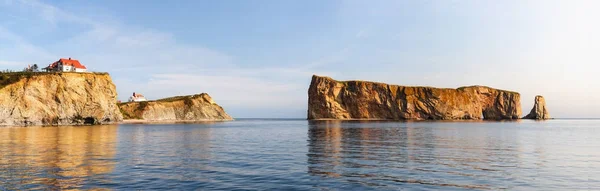
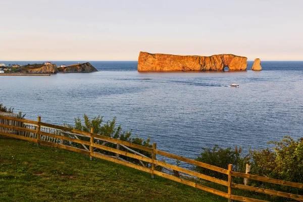
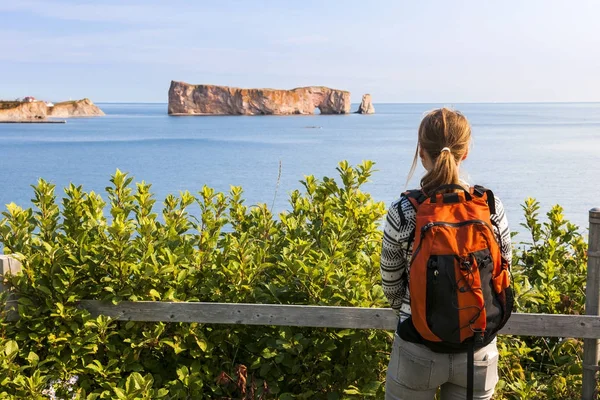
View Of The Perce Village, At The Tip Of Gaspe Peninsula, Quebec, Canada

Image, 15.28MB, 6000 × 4000 jpg
stock image Sunset in Forillon National Park

Sunset In Forillon National Park

Image, 15.22MB, 5964 × 3976 jpg
stock image Elevated footpath in the Penouille sector of Forillon National Park, Gaspe Peninsula, Quebec, Canada

Elevated Footpath In The Penouille Sector Of Forillon National Park, Gaspe Peninsula, Quebec, Canada

Image, 15.89MB, 6000 × 4000 jpg
stock image Sunset in Forillon National Park

Sunset In Forillon National Park

Image, 9.36MB, 5978 × 3987 jpg
stock image Landscape of forest and pools in the Penouille sector of Forillon National Park, Gaspe Peninsula, Quebec, Canada

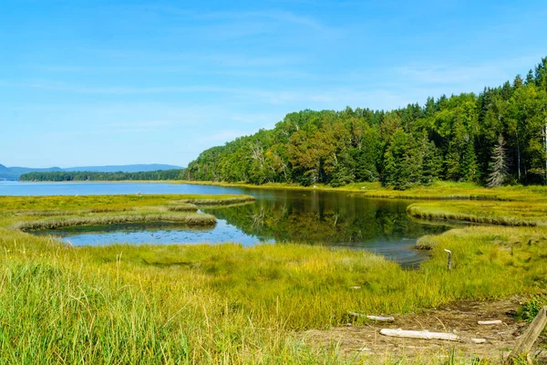
Landscape Of Forest And Pools In The Penouille Sector Of Forillon National Park, Gaspe Peninsula, Quebec, Canada

Image, 14.36MB, 6000 × 4000 jpg
stock image View of the Cap-des-Rosiers Lighthouse, Gaspe Peninsula, Quebec, Canada

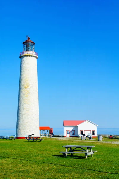
View Of The Cap-des-Rosiers Lighthouse, Gaspe Peninsula, Quebec, Canada

Image, 22.13MB, 4000 × 6000 jpg
stock image Perce rock, and Perce village

Perce Rock, And Perce Village

Image, 19.38MB, 5935 × 3957 jpg
stock image Perce Rock at sunset

Perce Rock At Sunset

Image, 18.6MB, 6048 × 4032 jpg
stock image A vertical shot of the van on the road. Perce Rock, Quebec, Canada.

A Vertical Shot Of The Van On The Road. Perce Rock, Quebec, Canada.

Image, 6MB, 2716 × 3775 jpg
stock image Penouille sector of Forillon National Park

Penouille Sector Of Forillon National Park

Image, 22.73MB, 6000 × 4000 jpg
stock image Female hiker viewing Perce Rock

Female Hiker Viewing Perce Rock

Image, 14.96MB, 6048 × 4032 jpg
stock image Golfo dei Poeti panorama

Golfo Dei Poeti Panorama

Image, 9.26MB, 3648 × 2736 jpg
stock image Rocher Perce in Gaspesie, Canada

Rocher Perce In Gaspesie, Canada

Image, 8.97MB, 4500 × 4500 jpg
stock image Portovenere Chiesa di San Lorenzo

Portovenere Chiesa Di San Lorenzo

Image, 8.43MB, 3648 × 2736 jpg
stock vector Newfoundland

Newfoundland

Vector, 1.58MB, 5055 × 8328 eps
stock vector Road map of the canada atlantic province new brunswick

Road Map Of The Canada Atlantic Province New Brunswick

Vector, 1.65MB, 3163 × 3100 eps
stock image Saint Pierre Island in the Gulf of St. Lawrence, belonging to France, isolated on a satellite image taken in July 8, 2023, with distance scale

Saint Pierre Island In The Gulf Of St. Lawrence, Belonging To France, Isolated On A Satellite Image Taken In July 8, 2023, With Distance Scale

Image, 1.99MB, 2160 × 2160 jpg
stock vector Road map of the canada atlantic province new brunswick

Road Map Of The Canada Atlantic Province New Brunswick

Vector, 1.65MB, 3157 × 3100 eps
stock vector Province quebec road vector map with flag

Province Quebec Road Vector Map With Flag

Vector, 2.25MB, 3100 × 3701 eps
stock image Saint Pierre Island in the Gulf of St. Lawrence, belonging to France, isolated on a topographic, OSM Humanitarian style map, with distance scale

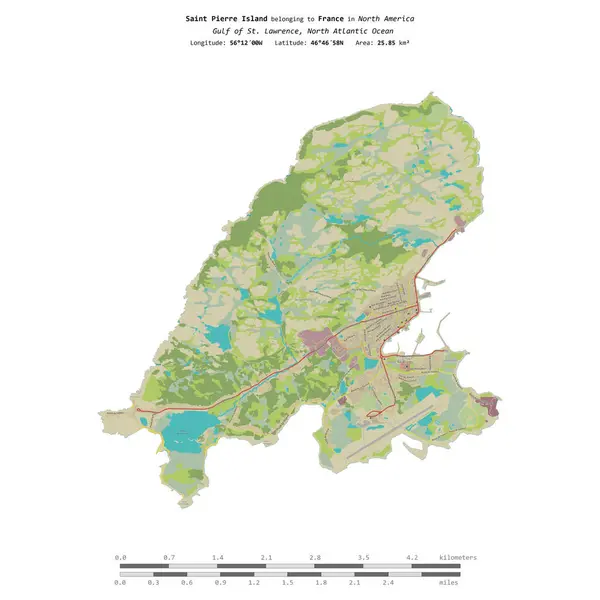
Saint Pierre Island In The Gulf Of St. Lawrence, Belonging To France, Isolated On A Topographic, OSM Humanitarian Style Map, With Distance Scale

Image, 1.57MB, 2160 × 2160 jpg
stock vector Newfoundland road map

Newfoundland Road Map

Vector, 1.73MB, 3118 × 3101 eps
Page 1 >> Next