Home
Images
Vectors
Videos
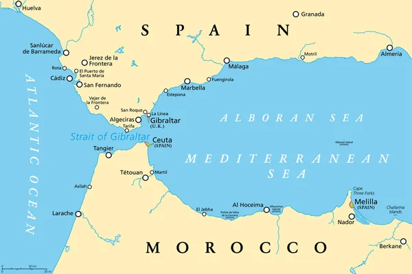
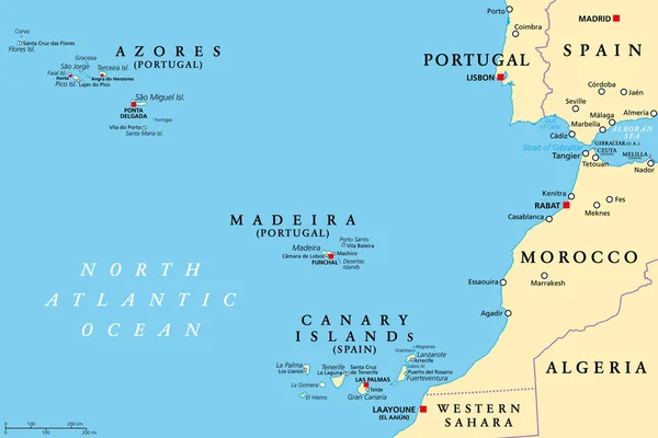
Stock vector Azores, Madeira, and Canary Islands, political map. Autonomous regions of Portugal and Spain, archipelagos of volcanic islands, in the Macaronesia region of North Atlantic ocean, next to North Africa.
Published:
Sep.24, 2022 15:14:32
Author:
Furian
Views:
336
Downloads:
4
File type:
vector
/
eps
File size:
3.06 MB
Orginal size:
9000
x
6000
px
Available sizes:
S
(500 x 333)
M
(1000 x 667)
L
(2000 x 1333)
XL
(9000 x 6000)
VECT
(9000 x 6000)
EL0
(9000 x 6000)
Level:
silver
Download Vector
Vector topics:
Group
Vector
Illustration
Travel
Ocean
Capital
North
Europe
Cruise
Country
Map
Cartography
Geography
Area
Africa
Continent
Portugal
Spain
Island
Atlantic
Islands
Region
Strait
Atlas
Volcanic
Fuerteventura
Lisbon
Morocco
Mapping
Canary
Canaries
Tenerife
Lanzarote
Madrid
Gomera
Madeira
Azores
Autonomous
Archipelago
Gibraltar
Terceira
Funchal
Canary Islands
North Africa
Sao Miguel
Gran Canaria
La Palma
Las Palmas
Ponta Delgada
Macaronesia
Similar stock vectors
Strait Of Gibraltar, Political Map. Also Known As Straits Of Gibraltar. Narrow Strait, Connecting The Atlantic Ocean To The Mediterranean Sea, Separating The Iberian Peninsula From Morocco And Africa.
9000 × 6000
Spain Administrative Map
4469 × 3428
Strait Of Gibraltar, Gray Political Map. Also Known As Straits Of Gibraltar. A Narrow Strait, Connecting Atlantic Ocean To Mediterranean Sea, Separating The Iberian Peninsula From Morocco And Africa.
9000 × 6000
Political Map Of Spain With Borders With Borders Of Regions And Countries
4000 × 4000
Spain And Its Neighborhood. Distant Oblique Perspective - Shape Outlined. Satellite Imagery
2880 × 1620
Morocco Map - Vintage Vector Illustration
7063 × 5500
Political Map Of Spain With National Borders, Cities And Rivers
4627 × 4000
The Mediterranean Sea, Political Map With Subdivisions, Straits, Islands And Countries. Connected To The Atlantic Ocean, Surrounded By The Mediterranean Basin, Almost Completely Enclosed By Land.
9000 × 4442