Home
Images
Vectors
Videos
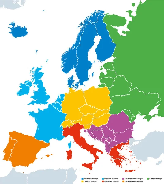
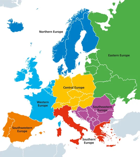
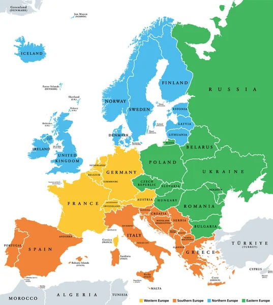
Stock vector Europe subregions, political map. Geoscheme, that subdivides the European continent into Eastern, Northern, Southern, and Western Europe, for statistical purposes, and represented in different colors.
Published:
Jun.21, 2022 17:27:29
Author:
Furian
Views:
94
Downloads:
0
File type:
vector
/
eps
File size:
4.43 MB
Orginal size:
6000
x
6699
px
Available sizes:
S
(448 x 500)
M
(896 x 1000)
L
(1791 x 2000)
XL
(6000 x 6699)
VECT
(6000 x 6699)
EL0
(6000 x 6699)
Level:
silver
Download Vector
Vector topics:
Color
Colors
Group
Vector
Illustration
Travel
European
Border
Italy
France
Scandinavia
Northern
Europe
Russia
Eastern
Country
Western
Map
Cartography
Geography
Continent
Germany
Land
Mediterranean
Spain
Overview
Boundary
Island
Political
Baltic
Atlantic
Statistics
Destination
Region
Southern
Stats
Statistical
Atlas
Specific
Nation
Subdivision
Mapping
Groupings
Infographic
White Background
Political Map
British Isles
Europe Map
Subregion
Geoscheme
Similar stock vectors
Regions Of Europe Political Map, Single Countries, English Labeling
7535 × 8433
Regions Of Europe, Political Map, With Single Countries
7535 × 8433
Colorful Map Of Europe Continent
4316 × 3863
Europe - Political Map Of Europe
4169 × 4170
European Union Countries, English Labeling, Political Map
7899 × 8133
Europe Regions, Political Map, With Single Countries
7535 × 8433
Map Of Europe With Blue Highlighted EU Member States And United Kingdom In Different Color. Vector Illustration. Simplified Map Of European Union
6000 × 6000
Vector Map Of European Continent With Countries, Capitals, Main Cities And Seas And Islands Names In Classic Soft Colors.
5615 × 5611