Home
Images
Vectors
Videos
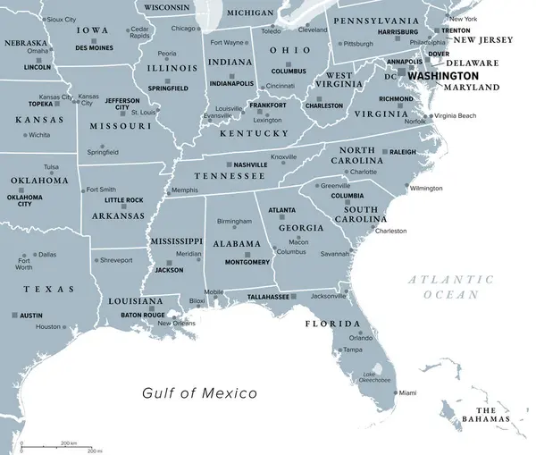
Stock vector South, census region of the United States of America, gray political map of census region 3, consisting of 13 single states and the District of Columbia. Map with geographical borders and capitals.
Published:
Aug.21, 2024 18:50:01
Author:
Furian
Views:
0
Downloads:
0
File type:
vector
/
eps
File size:
2.45 MB
Orginal size:
8955
x
6000
px
Available sizes:
S
(500 x 335)
M
(1000 x 670)
L
(2000 x 1340)
XL
(8955 x 6000)
VECT
(8955 x 6000)
EL0
(8955 x 6000)
Level:
silver
Download Vector
Vector topics:
Group
Vector
Illustration
Isolated
Silhouette
Border
Gray
Data
American
Usa
Capital
South
System
Country
Map
Cartography
Geography
Overview
State
Texas
America
Boundary
Administrative
Statistics
Georgia
Washington
Region
Division
Southern
Tennessee
Administration
Classification
Atlas
Maryland
Virginia
Florida
Subdivision
Delaware
Mapping
Geographical
Dixie
Carolina
Kentucky
Census
Infographic
United States
Political Map
South Atlantic
Census Region
Similar stock vectors
Southeast Region, South Of The United States, Gray Political Map. Geographic And Cultural Region, Also Referred To As The Southern United States, American South, Southland, Dixieland, Or Simply Dixie.
7059 × 6000
High Quality Map Of South Region Of United States Of America With Borders Of The States
4000 × 4000
Black Location Map Of US Federal State Of Louisiana Inside Gray Map Of The United States Of America
6002 × 4005
Black CMYK Federal Map Of LOUISIANA Inside Detailed Gray Blank Political Map Of The United States Of America On Transparent Background
6002 × 4005
Map Of States Of The United States Where Louisiana Is Pulled Out
5666 × 3848
Black CMYK Federal Map Of NORTH CAROLINA Inside Detailed Gray Blank Political Map Of The United States Of America On Transparent Background
6002 × 4005
Louisiana State In The United States Map
5000 × 5000