photo free
Home Images Vectors Videos

Stock image Grand Est Map

stock vector 3d map of world with borders

3d Map Of World With Borders

Vector, 37.6MB, 4000 × 4000 eps
stock vector 3d map of world with borders

3d Map Of World With Borders

Vector, 36.54MB, 6667 × 4000 eps
stock vector 3d map of Europe with borders

3d Map Of Europe With Borders

Vector, 5.03MB, 4000 × 4000 eps
stock vector 3d map of Europe with borders

3d Map Of Europe With Borders

Vector, 6MB, 4000 × 4000 eps
stock vector 3d map of Africa with borders

3d Map Of Africa With Borders

Vector, 3.85MB, 4000 × 4000 eps
stock vector Vector color detailed map of metropolis and overseas territories of France  with administrative divisions of the country, each region is presented separately in-highly detailed and divided into departments

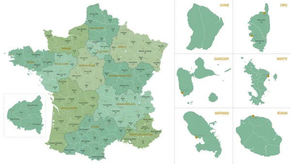
Vector Color Detailed Map Of Metropolis And Overseas Territories Of France With Administrative Divisions Of The Country, Each Region Is Presented Separately In-highly Detailed And Divided Into Departments

Vector, 5.32MB, 7677 × 4274 eps
stock vector 3d isometric Map of Grand Est is a region of France with national flag

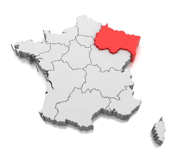
3d Isometric Map Of Grand Est Is A Region Of France With National Flag

Vector, 11.6MB, 4000 × 4000 eps
stock vector map of the city of Reims, Marne, Grand Est, France

Map Of The City Of Reims, Marne, Grand Est, France

Vector, 6.86MB, 6122 × 3544 eps
stock vector Detailed map of metropolis and overseas territories of France with administrative divisions into regions and departments, large cities of the country, vector illustration on a white background

Detailed Map Of Metropolis And Overseas Territories Of France With Administrative Divisions Into Regions And Departments, Large Cities Of The Country, Vector Illustration On A White Background

Vector, 4.5MB, 7677 × 4326 eps
stock vector Grand Est french region map

Grand Est French Region Map

Vector, 1.85MB, 4094 × 4876 eps
stock vector France map, new political detailed map, separate individual regions, with state names, isolated on white background 3D vector

France Map, New Political Detailed Map, Separate Individual Regions, With State Names, Isolated On White Background 3D Vector

Vector, 3.97MB, 4000 × 4000 eps
stock vector France map separate region names individual card blackboard chalkboard vector

France Map Separate Region Names Individual Card Blackboard Chalkboard Vector

Vector, 9.15MB, 4000 × 4000 eps
stock vector administrative map of the new french region grand est with logo

Administrative Map Of The New French Region Grand Est With Logo

Vector, 1.53MB, 3924 × 3100 eps
stock vector administrative map of the new french region grand est

Administrative Map Of The New French Region Grand Est

Vector, 1.62MB, 3930 × 3100 eps
stock image Map of Grand Est region, France

Map Of Grand Est Region, France

Image, 2.67MB, 4200 × 3675 jpg
stock vector Grand Est region outline map set

Grand Est Region Outline Map Set

Vector, 0.92MB, 6000 × 3000 eps
stock vector Detailed map of the French region Grand Est (France) with borders of municipalities, subdistricts (cantons), districts (arrondissements), departments (departements), and region

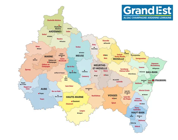
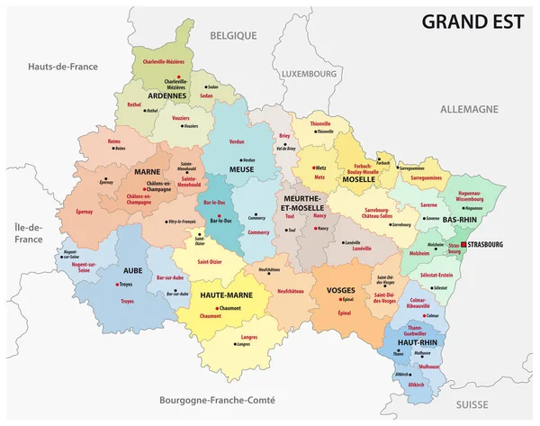
Detailed Map Of The French Region Grand Est (France) With Borders Of Municipalities, Subdistricts (cantons), Districts (arrondissements), Departments (departements), And Region

Vector, 8.61MB, 5000 × 5000 eps
stock vector Paraguay Political Map

Paraguay Political Map

Vector, 3.48MB, 6166 × 6000 eps
stock vector Greater East of France map symbol shape, travel web flat concept icon symbol vector .

Greater East Of France Map Symbol Shape, Travel Web Flat Concept Icon Symbol Vector .

Vector, 0.72MB, 4096 × 4096 eps
Page 1 >> Next