photo free
Home Images Vectors Videos

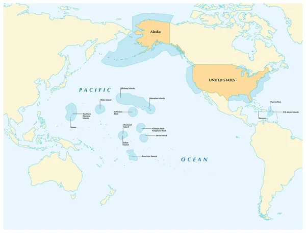
Stock image Insular State

stock vector button st kitts and nevis

Button St Kitts And Nevis

Vector, 0MB, 6872 × 6944 zip
stock vector flag of sri lanka, vector illustration

Flag Of Sri Lanka, Vector Illustration

Vector, 0MB, 4000 × 4000 zip
stock vector map of the world, copy space

Map Of The World, Copy Space

Vector, 0MB, 4616 × 5832 zip
stock vector button st. vincent and the grenadines

Button St. Vincent And The Grenadines

Vector, 0MB, 6872 × 6840 zip
stock image scenic view of island, selective focus

Scenic View Of Island, Selective Focus

Image, 0MB, 3264 × 1836 jpg
stock image different architecture, selective focus

Different Architecture, Selective Focus

Image, 0MB, 5184 × 2916 jpg
stock image skyline of abu dhabi on the beach

Skyline Of Abu Dhabi On The Beach

Image, 0MB, 3787 × 2500 jpg
stock image climate change, arctic iceberg

Climate Change, Arctic Iceberg

Image, 0MB, 5184 × 3456 jpg
stock vector Flag of Martinique, France

Flag Of Martinique, France

Vector, 6.28MB, 8333 × 5538 eps
stock vector insular area vector map of the United States.

Insular Area Vector Map Of The United States.

Vector, 3.06MB, 4078 × 3100 eps
stock vector Northern Mariana Islands political map

Northern Mariana Islands Political Map

Vector, 2.47MB, 6974 × 8999 eps
stock image Flag of Guadeloupe

Flag Of Guadeloupe

Image, 6.19MB, 4288 × 2848 jpg
stock vector Northern Mariana Islands political map

Northern Mariana Islands Political Map

Vector, 2.05MB, 6444 × 9666 eps
stock image Profile of female silhouette on window background. Woman looking out the window.

Profile Of Female Silhouette On Window Background. Woman Looking Out The Window.

Image, 9.81MB, 6000 × 4000 jpg
stock vector Guam and Northern Mariana Islands, political map. Two separate unincorporated territories of the United States of America in the Micronesia subregion of the Western Pacific Ocean. Illustration. Vector

Guam And Northern Mariana Islands, Political Map. Two Separate Unincorporated Territories Of The United States Of America In The Micronesia Subregion Of The Western Pacific Ocean. Illustration. Vector

Vector, 3.12MB, 6000 × 6000 eps
stock vector Borneo, divided among Malaysia, Brunei and Indonesia, political map. Third-largest island in the world and one of the Greater Sunda Islands, in the geographic centre of Maritime Southeast Asia. Vector

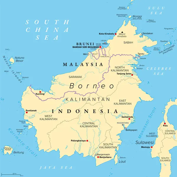
Borneo, Divided Among Malaysia, Brunei And Indonesia, Political Map. Third-largest Island In The World And One Of The Greater Sunda Islands, In The Geographic Centre Of Maritime Southeast Asia. Vector

Vector, 6.35MB, 6000 × 6000 eps
stock vector Saipan and Tinian, Northern Mariana Islands, gray political map. Islands of the Mariana Archipelago. Unincorporated territory and commonwealth of United States with administrative center Capitol Hill.

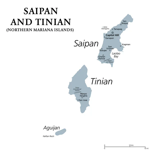
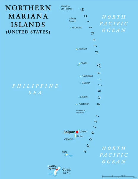
Saipan And Tinian, Northern Mariana Islands, Gray Political Map. Islands Of The Mariana Archipelago. Unincorporated Territory And Commonwealth Of United States With Administrative Center Capitol Hill.

Vector, 1.42MB, 6000 × 6000 eps
stock vector Guam and Northern Mariana Islands, gray political map. Two separate unincorporated territories of the United States of America in the Micronesia subregion of the Western Pacific Ocean. Illustration.

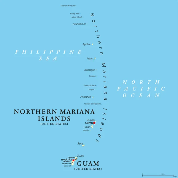
Guam And Northern Mariana Islands, Gray Political Map. Two Separate Unincorporated Territories Of The United States Of America In The Micronesia Subregion Of The Western Pacific Ocean. Illustration.

Vector, 2.02MB, 6000 × 8996 eps
stock vector Wake Island, gray political map. Also called Wake Atoll, a coral atoll in the Pacific in the northeastern area of Micronesia. Unorganized, unincorporated territory of the United States. Illustration.

Wake Island, Gray Political Map. Also Called Wake Atoll, A Coral Atoll In The Pacific In The Northeastern Area Of Micronesia. Unorganized, Unincorporated Territory Of The United States. Illustration.

Vector, 2.25MB, 6000 × 6000 eps
stock vector Borneo, divided among Malaysia, Brunei and Indonesia, gray political map. Third-largest island in the world, and one of the Greater Sunda Islands, in the geographic centre of Maritime Southeast Asia.

Borneo, Divided Among Malaysia, Brunei And Indonesia, Gray Political Map. Third-largest Island In The World, And One Of The Greater Sunda Islands, In The Geographic Centre Of Maritime Southeast Asia.

Vector, 4.03MB, 6000 × 6000 eps
Page 1 >> Next