photo free
Home Images Vectors Videos

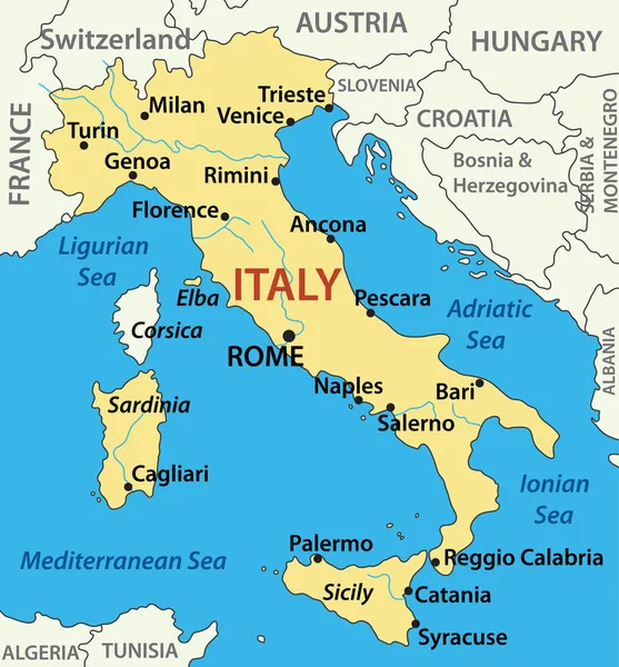
Stock image Ligurian Map

stock vector Liguria outline map set

Liguria Outline Map Set

Vector, 1.38MB, 6283 × 3442 eps
stock vector Mediterranean Basin Political Map

Mediterranean Basin Political Map

Vector, 4.36MB, 9000 × 3226 eps
stock image Satellite View of  Lake Maggiore, Como and Lecco, reliefs, Italy

Satellite View Of Lake Maggiore, Como And Lecco, Reliefs, Italy

Image, 8.64MB, 4724 × 3333 jpg
stock image Satellite View of  Lake Maggiore, Como and Lecco, reliefs, Italy.

Satellite View Of Lake Maggiore, Como And Lecco, Reliefs, Italy.

Image, 8.43MB, 4724 × 3333 jpg
stock vector Mediterranean sea

Mediterranean Sea

Vector, 2.79MB, 6000 × 4646 eps
stock vector France Political Map

France Political Map

Vector, 3.03MB, 6000 × 6270 eps
stock image Satellite View of  Lake Maggiore, Como and Lecco, reliefs, Italy

Satellite View Of Lake Maggiore, Como And Lecco, Reliefs, Italy

Image, 9.41MB, 4724 × 2964 jpg
stock vector Mediterranean Sea Region Political Map

Mediterranean Sea Region Political Map

Vector, 3.05MB, 8987 × 4436 eps
stock vector The Mediterranean Sea, political map with subdivisions, straits, islands and countries. Connected to the Atlantic Ocean, surrounded by the Mediterranean Basin, almost completely enclosed by land.

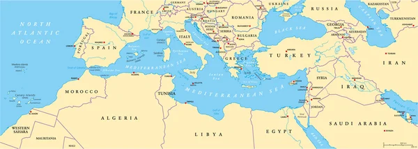
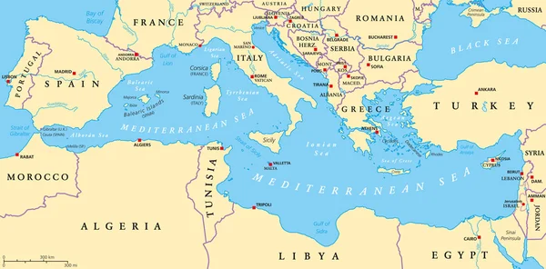
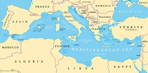
The Mediterranean Sea, Political Map With Subdivisions, Straits, Islands And Countries. Connected To The Atlantic Ocean, Surrounded By The Mediterranean Basin, Almost Completely Enclosed By Land.

Vector, 3.7MB, 9000 × 4442 eps
stock vector vector map of the two mediterranean sea islands of corsica and sardinia

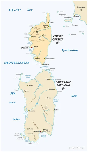
Vector Map Of The Two Mediterranean Sea Islands Of Corsica And Sardinia

Vector, 1.13MB, 3100 × 5317 eps
stock vector map of adriatic sea

Map Of Adriatic Sea

Vector, 0.76MB, 2080 × 2400 eps
stock vector administrative map of the ligurian capital genoa with flag italy

Administrative Map Of The Ligurian Capital Genoa With Flag Italy

Vector, 0.66MB, 6152 × 3100 eps
stock vector Map of Italy - vector illustration

Map Of Italy - Vector Illustration

Vector, 0.55MB, 2284 × 2456 eps
stock vector administrative and political map of the metropolitan city of Genoa in the region of Liguria Italy

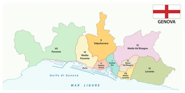
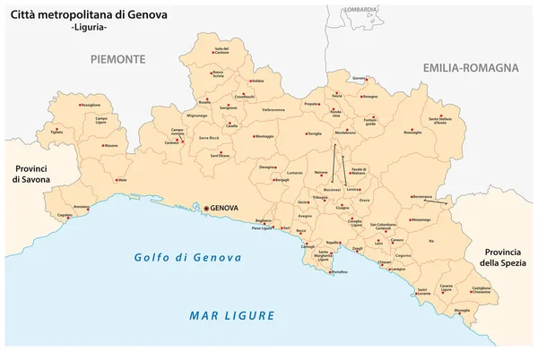
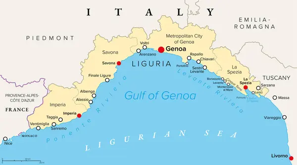
Administrative And Political Map Of The Metropolitan City Of Genoa In The Region Of Liguria Italy

Vector, 1.22MB, 4735 × 3100 eps
stock image Cote d'azur nice from a bird's eye drone

Cote D'azur Nice From A Bird's Eye Drone

Image, 3.56MB, 3230 × 1894 jpg
stock vector Vector Italy Pictogram

Vector Italy Pictogram

Vector, 1.86MB, 5000 × 5000 eps
stock vector Tuscan Archipelago, Italy, political map. Chain of islands between Ligurian Sea and Tyrrhenian Sea, west of Tuscany, between Corsica and Italian Peninsula. Most known islands are Elba and Montecristo.

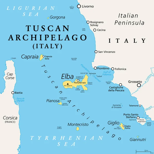
Tuscan Archipelago, Italy, Political Map. Chain Of Islands Between Ligurian Sea And Tyrrhenian Sea, West Of Tuscany, Between Corsica And Italian Peninsula. Most Known Islands Are Elba And Montecristo.

Vector, 2.66MB, 6000 × 6000 eps
stock vector Political map of France with national borders, cities and rivers

Political Map Of France With National Borders, Cities And Rivers

Vector, 2.14MB, 4000 × 4000 eps
stock vector Southern France coasts, political map. Southernmost part of France, bordering the Mediterranean Sea. Map with Provence and French Riviera, Corsica and part of Liguria and Italian Riviera, and Corsica.

Southern France Coasts, Political Map. Southernmost Part Of France, Bordering The Mediterranean Sea. Map With Provence And French Riviera, Corsica And Part Of Liguria And Italian Riviera, And Corsica.

Vector, 2.49MB, 9000 × 6000 eps
stock image Corsica Island in the Ligurian Sea, belonging to France, isolated on a satellite image taken in December 15, 2023, with distance scale

Corsica Island In The Ligurian Sea, Belonging To France, Isolated On A Satellite Image Taken In December 15, 2023, With Distance Scale

Image, 1.41MB, 2160 × 2160 jpg
stock vector Liguria and the Italian Riviera, or Ligurian Riviera, gray political map. Region of north-western Italy, with capital Genoa. Narrow coastal strip between Ventimiglia and La Spezia on the Ligurian Sea.

Liguria And The Italian Riviera, Or Ligurian Riviera, Gray Political Map. Region Of North-western Italy, With Capital Genoa. Narrow Coastal Strip Between Ventimiglia And La Spezia On The Ligurian Sea.

Vector, 2.28MB, 9000 × 5033 eps
stock vector Liguria Italian region map silhouette tagcloud with local dishes

Liguria Italian Region Map Silhouette Tagcloud With Local Dishes

Vector, 2.5MB, 6600 × 3900 eps
stock image Liguria on the map of Italy in soft grunge and vintage style, like old paper with watercolor painting.

Liguria On The Map Of Italy In Soft Grunge And Vintage Style, Like Old Paper With Watercolor Painting.

Image, 14.4MB, 6000 × 6000 jpg
stock image Corsica Island in the Ligurian Sea on a colored elevation map

Corsica Island In The Ligurian Sea On A Colored Elevation Map

Image, 2.66MB, 2880 × 1620 jpg
stock vector Southern France coastline, political map. Southernmost part of France, that border the Mediterranean Sea. Map with part of Occitania, Provence, French Riviera, Corsica, and with most important cities.

Southern France Coastline, Political Map. Southernmost Part Of France, That Border The Mediterranean Sea. Map With Part Of Occitania, Provence, French Riviera, Corsica, And With Most Important Cities.

Vector, 3.28MB, 9000 × 5999 eps
stock image Corsica Island in the Ligurian Sea - belonging to France. Described location diagram with yellow shape of the island and sample maps of its surroundings

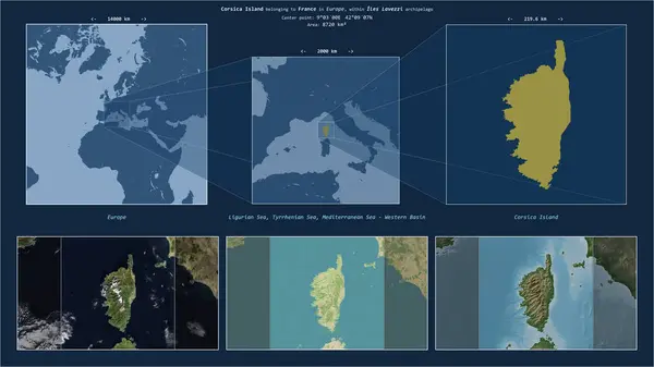
Corsica Island In The Ligurian Sea - Belonging To France. Described Location Diagram With Yellow Shape Of The Island And Sample Maps Of Its Surroundings

Image, 2.84MB, 3840 × 2160 jpg
stock image Corsica Island in the Ligurian Sea, belonging to France, isolated on a bilevel elevation map, with distance scale

Corsica Island In The Ligurian Sea, Belonging To France, Isolated On A Bilevel Elevation Map, With Distance Scale

Image, 0.66MB, 2160 × 2160 jpg
stock image Corsica Island in the Ligurian Sea on a satellite image taken in June 23, 2023

Corsica Island In The Ligurian Sea On A Satellite Image Taken In June 23, 2023

Image, 3.85MB, 2880 × 1620 jpg
stock image Corsica Island in the Ligurian Sea, belonging to France, isolated on a topographic, OSM Humanitarian style map, with distance scale

Corsica Island In The Ligurian Sea, Belonging To France, Isolated On A Topographic, OSM Humanitarian Style Map, With Distance Scale

Image, 1.21MB, 2160 × 2160 jpg
stock vector Liguria and the Italian Riviera, the Ligurian Riviera, political map. Region of north-western Italy, with capital Genoa. A narrow coastal strip between Ventimiglia and La Spezia, on the Ligurian Sea.

Liguria And The Italian Riviera, The Ligurian Riviera, Political Map. Region Of North-western Italy, With Capital Genoa. A Narrow Coastal Strip Between Ventimiglia And La Spezia, On The Ligurian Sea.

Vector, 2.46MB, 9000 × 5033 eps
stock vector French Riviera coasts, political map. Mediterranean coastline of the southeast corner of France, also Cote dAzur or Azure Coast, considered to extend from Toulon in the west to Menton in the east.

French Riviera Coasts, Political Map. Mediterranean Coastline Of The Southeast Corner Of France, Also Cote DAzur Or Azure Coast, Considered To Extend From Toulon In The West To Menton In The East.

Vector, 2.16MB, 7817 × 6000 eps
stock image Corsica Island in the Ligurian Sea on a topographic, OSM Humanitarian style map

Corsica Island In The Ligurian Sea On A Topographic, OSM Humanitarian Style Map

Image, 2.35MB, 2880 × 1620 jpg
Page 1 >> Next