photo free
Home Images Vectors Videos

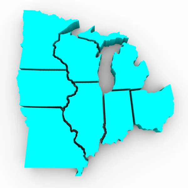
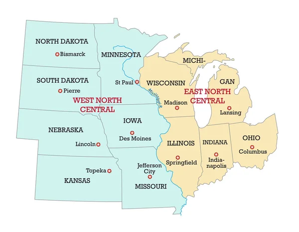
Stock image Midwest Region

stock vector Map of the Midwest United States of America

Map Of The Midwest United States Of America

Vector, 3MB, 4387 × 3100 eps
stock vector Map of United States split into Census regions and divisions. Region definition, widely used for data collection and analysis. Most commonly used classification system. English. Illustration. Vector

Map Of United States Split Into Census Regions And Divisions. Region Definition, Widely Used For Data Collection And Analysis. Most Commonly Used Classification System. English. Illustration. Vector

Vector, 3.06MB, 9000 × 6000 eps
stock image Huge green leaves wheat crop plantation in Mato Grosso do Sul State in mid-west region of Brazil. Brazil is one of the biggest wheat producers in the world

Huge Green Leaves Wheat Crop Plantation In Mato Grosso Do Sul State In Mid-west Region Of Brazil. Brazil Is One Of The Biggest Wheat Producers In The World

Image, 5.88MB, 4000 × 2667 jpg
stock image Ennis at night

Ennis At Night

Image, 6.03MB, 3700 × 2457 jpg
stock image Missouri

Missouri

Image, 1.69MB, 4300 × 2800 jpg
stock image Great Lakes Region of States - 3d Map

Great Lakes Region Of States - 3d Map

Image, 2.62MB, 4096 × 4096 jpg
stock image State of Missouri map

State Of Missouri Map

Image, 1.55MB, 4300 × 2800 jpg
stock image State of Missouri map

State Of Missouri Map

Image, 0.86MB, 4300 × 2800 jpg
stock vector Flag of County Clare is a county in Ireland, in the Mid-West Region and the province of Munster. Vector illustration

Flag Of County Clare Is A County In Ireland, In The Mid-West Region And The Province Of Munster. Vector Illustration

Vector, 5.66MB, 6271 × 4167 eps
stock image Map of Brazil with midwest region

Map Of Brazil With Midwest Region

Image, 3.44MB, 5000 × 4500 jpg
stock image Lush cornfield under a clear blue sky in Fort Wayne, Indiana. Tall, green stalks thrive in late summer, embodying the essence of Midwest agriculture. Ideal for themes of farming, rural life, and crop

Lush Cornfield Under A Clear Blue Sky In Fort Wayne, Indiana. Tall, Green Stalks Thrive In Late Summer, Embodying The Essence Of Midwest Agriculture. Ideal For Themes Of Farming, Rural Life, And Crop

Image, 33.99MB, 6240 × 4160 jpg
stock vector United States, Madison, Wisconsin, Wisconsin State Capitol travel landmark line vector illustration

United States, Madison, Wisconsin, Wisconsin State Capitol Travel Landmark Line Vector Illustration

Vector, 1.33MB, 8000 × 8000 eps
stock vector United States, geographic regions, colored political map. Five regions, according to their geographic position on the continent. Common but unofficial way of referring to regions of the United States.

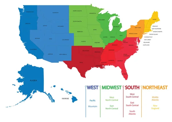
United States, Geographic Regions, Colored Political Map. Five Regions, According To Their Geographic Position On The Continent. Common But Unofficial Way Of Referring To Regions Of The United States.

Vector, 3.6MB, 8832 × 6000 eps
stock vector Map of US regions. Maps USA

Map Of US Regions. Maps USA

Vector, 3.51MB, 7087 × 5011 eps
stock image Entrance to the second floor of the barn

Entrance To The Second Floor Of The Barn

Image, 4.76MB, 4912 × 3264 jpg
stock image Morning Reflections on a Calm Pond

Morning Reflections On A Calm Pond

Image, 9.23MB, 4928 × 3264 jpg
stock vector Illustration of Farm

Illustration Of Farm

Vector, 0.54MB, 4792 × 3972 eps
stock image Red barn on farm in winter

Red Barn On Farm In Winter

Image, 5.57MB, 4912 × 3264 jpg
stock vector Illustration of Farm

Illustration Of Farm

Vector, 0.24MB, 4792 × 3972 eps
stock image Sand Point Lighthouse Nautical Beacon Escanaba Lake Michigan

Sand Point Lighthouse Nautical Beacon Escanaba Lake Michigan

Image, 14.04MB, 6048 × 4032 jpg
stock vector Combine on Farm

Combine On Farm

Vector, 0.33MB, 4792 × 2283 eps
stock vector Combine on Farm

Combine On Farm

Vector, 0.13MB, 4792 × 2283 eps
stock vector Harvest of Wheat

Harvest Of Wheat

Vector, 0.14MB, 4792 × 9515 eps
stock vector Chicago Hot Dog

Chicago Hot Dog

Vector, 0.15MB, 4792 × 2178 eps
stock vector Chicago Loop

Chicago Loop

Vector, 0.46MB, 4792 × 7774 eps
stock vector Ohio, Pennsylvania, Hawaii, Alaska, Indiana USA state outline ar

Ohio, Pennsylvania, Hawaii, Alaska, Indiana USA State Outline Ar

Vector, 14.62MB, 5000 × 5000 eps
stock vector Wisconsin Cheese Head

Wisconsin Cheese Head

Vector, 0.34MB, 4792 × 7020 eps
stock image Dual Lighthouses Grand Haven Nautical Markers Lake Michigan

Dual Lighthouses Grand Haven Nautical Markers Lake Michigan

Image, 7.14MB, 5999 × 3476 jpg
stock vector Montana, North Dakota, South Dakota, Kansas, Nebraska USA state

Montana, North Dakota, South Dakota, Kansas, Nebraska USA State

Vector, 14.34MB, 5000 × 5000 eps
stock vector Chicago Loop

Chicago Loop

Vector, 0.19MB, 4792 × 7498 eps
stock vector Vector illustration of the Indiana Welcome You road sign

Vector Illustration Of The Indiana Welcome You Road Sign

Vector, 1.49MB, 8500 × 6202 ai
stock image American Real Estate

American Real Estate

Image, 7.78MB, 8333 × 6250 jpg
stock image crosswords of northwest arranged by cubic letters on a mirror floor, concept meaning and presentation. pacific and landscape

Crosswords Of Northwest Arranged By Cubic Letters On A Mirror Floor, Concept Meaning And Presentation. Pacific And Landscape

Image, 4.34MB, 3840 × 2160 jpg
stock vector Woodcut Illustration of Paddlewheel Boat

Woodcut Illustration Of Paddlewheel Boat

Vector, 0.38MB, 4792 × 5054 eps
stock vector Wisconsin Cheese Head

Wisconsin Cheese Head

Vector, 0.63MB, 4792 × 7020 eps
stock vector Minnesota, Wisconsin, Michigan,Iowa, Illinois USA state outline

Minnesota, Wisconsin, Michigan,Iowa, Illinois USA State Outline

Vector, 14.72MB, 5000 × 5000 eps
stock vector Custom lettering of the names of the American states, USA typogr

Custom Lettering Of The Names Of The American States, USA Typogr

Vector, 0.69MB, 5000 × 3654 eps
stock vector Nebraska, NE, political map with the capital Lincoln and the largest city Omaha. Triply landlocked State in the Midwestern subregion of the United States of America, nicknamed Cornhusker State. Vector

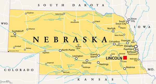
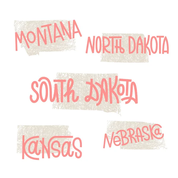
Nebraska, NE, Political Map With The Capital Lincoln And The Largest City Omaha. Triply Landlocked State In The Midwestern Subregion Of The United States Of America, Nicknamed Cornhusker State. Vector

Vector, 2.78MB, 9000 × 4854 eps
stock vector Regions of the United States of America, political map. The nine regions New England, Great Plains, Rocky Mountain, Mid Atlantic, South, West Coast, Midwest, Southwest, Alaska and Hawaii. Illustration

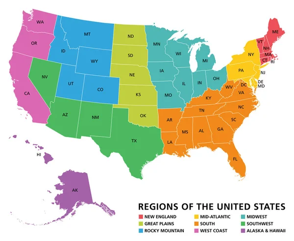
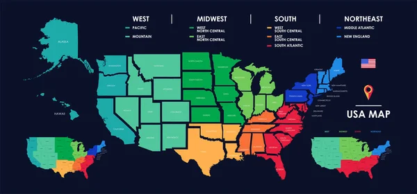
Regions Of The United States Of America, Political Map. The Nine Regions New England, Great Plains, Rocky Mountain, Mid Atlantic, South, West Coast, Midwest, Southwest, Alaska And Hawaii. Illustration

Vector, 3.42MB, 7322 × 6000 eps
stock vector Telecommunications network of the USA, Abstract mesh polygonal ggeographic map, detailed map of the states of America blank for design

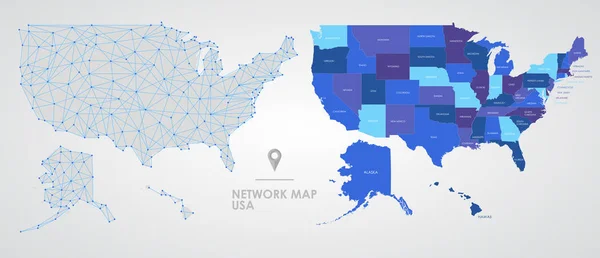
Telecommunications Network Of The USA, Abstract Mesh Polygonal Ggeographic Map, Detailed Map Of The States Of America Blank For Design

Vector, 5.38MB, 10431 × 4488 eps
stock vector Ohio, Oklahoma and New Mexico USA state rusty metal banners. Vector American travel and tourism old signboards with stars, eagle feathers, ceremonial pipe and red sun symbol

Ohio, Oklahoma And New Mexico USA State Rusty Metal Banners. Vector American Travel And Tourism Old Signboards With Stars, Eagle Feathers, Ceremonial Pipe And Red Sun Symbol

Vector, 5.26MB, 4840 × 5785 eps
stock vector USA states travel and tourism grunge banners with vector American Michigan, Montana and Maine. Vintage signs and postcards of US state nicknames with Great Lake, treasure and pine tree letterings

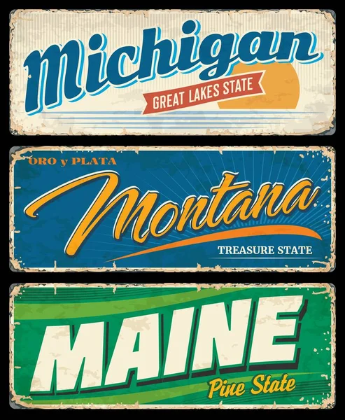
USA States Travel And Tourism Grunge Banners With Vector American Michigan, Montana And Maine. Vintage Signs And Postcards Of US State Nicknames With Great Lake, Treasure And Pine Tree Letterings

Vector, 5.34MB, 4798 × 5836 eps
stock vector South Dakota, SD, political map, with capital Pierre, and largest city Sioux Falls. State in the upper Midwestern subregion of the United States of America, nicknamed The Mount Rushmore State. Vector.

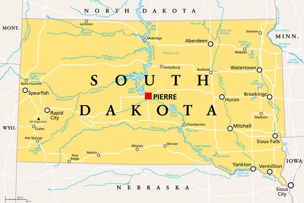
South Dakota, SD, Political Map, With Capital Pierre, And Largest City Sioux Falls. State In The Upper Midwestern Subregion Of The United States Of America, Nicknamed The Mount Rushmore State. Vector.

Vector, 3.62MB, 9000 × 5999 eps
stock vector Detailed map of US regions, isolated states with names, Colorful infographics of the United States of America, vector illustration

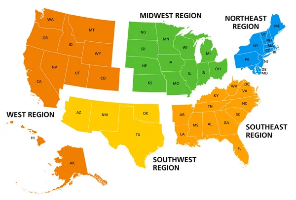
Detailed Map Of US Regions, Isolated States With Names, Colorful Infographics Of The United States Of America, Vector Illustration

Vector, 8.08MB, 11205 × 5237 eps
stock vector United States, Census regions and divisions, political map. Region definition widely used for data collection and analysis. The most commonly used classification system. English. Illustration. Vector.

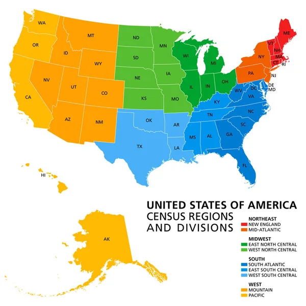
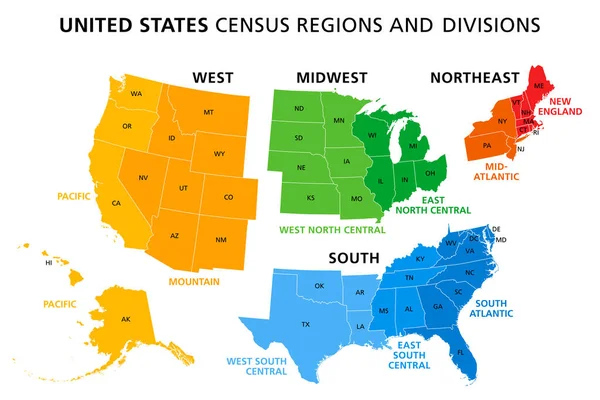
United States, Census Regions And Divisions, Political Map. Region Definition Widely Used For Data Collection And Analysis. The Most Commonly Used Classification System. English. Illustration. Vector.

Vector, 3.89MB, 6000 × 6000 eps
stock vector Kansas, KS, political map with capital Topeka, important rivers and lakes. State in the Midwestern United States of America nicknamed The Sunflower State, also The Wheat or The Jayhawker State. Vector

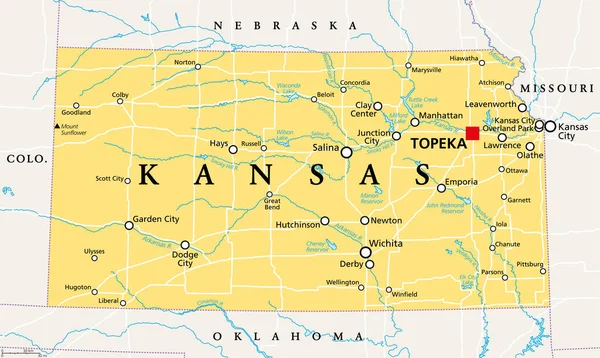
Kansas, KS, Political Map With Capital Topeka, Important Rivers And Lakes. State In The Midwestern United States Of America Nicknamed The Sunflower State, Also The Wheat Or The Jayhawker State. Vector

Vector, 3.32MB, 9000 × 5379 eps
stock vector Detailed vintage map of the United States of America split into

Detailed Vintage Map Of The United States Of America Split Into

Vector, 24.72MB, 7296 × 4104 eps
stock image Happy child in the snow

Happy Child In The Snow

Image, 6.42MB, 3264 × 4928 jpg
stock vector Map of the Midwest United States of America

Map Of The Midwest United States Of America

Vector, 0.7MB, 3988 × 3100 eps
Page 1 >> Next